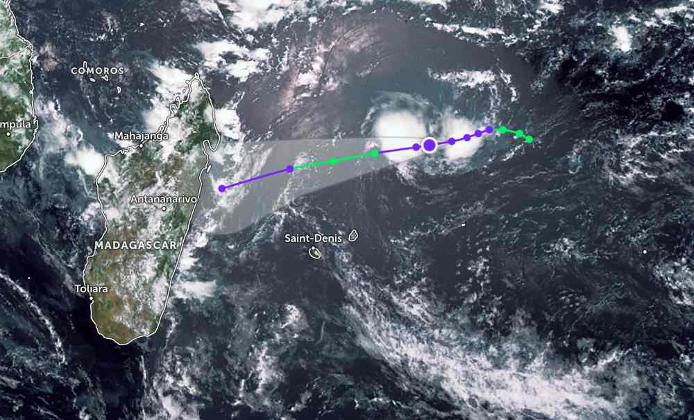
According to the latest storm news from the Joint Typhoon Warning Center (JTWC), in the afternoon of January 4 (local time), the weakened tropical depression from Typhoon Grant continued to strengthen in the Indian Ocean.
The center of the tropical depression is located 774 km northeast of Port Louis (Mauritius). In the past 6 hours, the tropical depression has moved in a West-Southwest direction at a speed of 15 km/h. The maximum wave height reached 3.7 m.
In the next 6 hours, the tropical depression will continue to move in a West-Southwest direction, towards Madagascar. The tropical depression is expected to strengthen into a storm tomorrow morning, January 5, with maximum winds reaching 65 km/h.
This system is forecast to gradually weaken and potentially disintegrate before approaching the east coast of Madagascar. However, the storm is expected to cause thunderstorms at sea and in many areas of the mainland east of Madagascar.
In the East Sea, according to the National Center for Hydro-Meteorological Forecasting, this afternoon and tonight, January 4, the Northern East Sea area (including Hoang Sa special zone) and the sea area from Gia Lai to Dak Lak, the Central East Sea area: Northeast wind level 6, gusts level 7-8; rough seas; night wind gradually decreases; waves 3.0-5.0m high.
The sea area from Khanh Hoa to Ca Mau and the western sea area of the South East Sea (including the western sea area of the Truong Sa special zone) have Northeast wind level 6, sometimes level 7, gusts level 8-9; rough seas; waves are 4.0-6.0m high.
In addition, the Central and South East Sea areas (including the Truong Sa special zone) will have scattered showers and thunderstorms. In thunderstorms, there is a possibility of tornadoes and strong gusts of wind.
From the night of January 5, the Gulf of Tonkin area will have strong Northeast wind at level 6, gusting at level 7-8; rough seas; waves 2.0-3.0m high. Northern East Sea area (including Hoang Sa special zone): strong Northeast wind at level 6, sometimes level 7, gusting at level 8-9; rough seas; waves 3.0-5.0m high.
From January 6, the sea area from South Quang Tri to Khanh Hoa and the Central East Sea area will have strong Northeast winds at level 6, gusts at level 7-8; rough seas; waves 3.0-5.0m high.
Sea area from Lam Dong to Ca Mau and the western sea area of the South East Sea (including the western sea area of Truong Sa special zone): strong Northeast wind level 6, sometimes level 7, gusts level 8-9; rough seas; waves 4.0-6.0m high.
People and tourists who plan to visit these sea areas should pay attention to weather forecasts. Avoid going out to sea when the sea is rough and follow local safety instructions.


