
According to storm news, the latest low pressure from the Joint Typhoon Warning Center (JTWC), Typhoon Saudel has strengthened into a typhoon over the northwest Pacific Ocean.
As of the afternoon of August 25, the center of Typhoon Saudel (Philippines name is Obet, Japanese name is Typhoon No. 18) is currently about 333 km east of Kadena Air Base. The strongest wind near the center of the typhoon reached 165 km/h.
In the past 6 hours, the storm has moved in a West-Northwest direction at a speed of 22 km/h. The highest wave height reached 13.7 m.
Typhoon Saudel is forecast to continue moving northwest in the near future. It is expected that after about 12 hours, Typhoon Saudel will pass through the Ryukyu Islands with winds of about 155 km/h.
In the next 12-24 hours, the storm will encounter a weakening zone, causing the storm's moving speed to decrease when entering the East Sea in the next 1-2 days.
The storm is forecast to make landfall in eastern China in about 3 days and weaken and disintegrate in about 5 days.
Meanwhile, storm No. 4 is gradually weakening in the East Sea. According to the National Center for Hydro-Meteorological Forecasting, at 13:00 on August 25, the storm's center was located at about 19.4 degrees North latitude - 108.1 degrees East longitude, over the Southern Gulf of Tonkin.
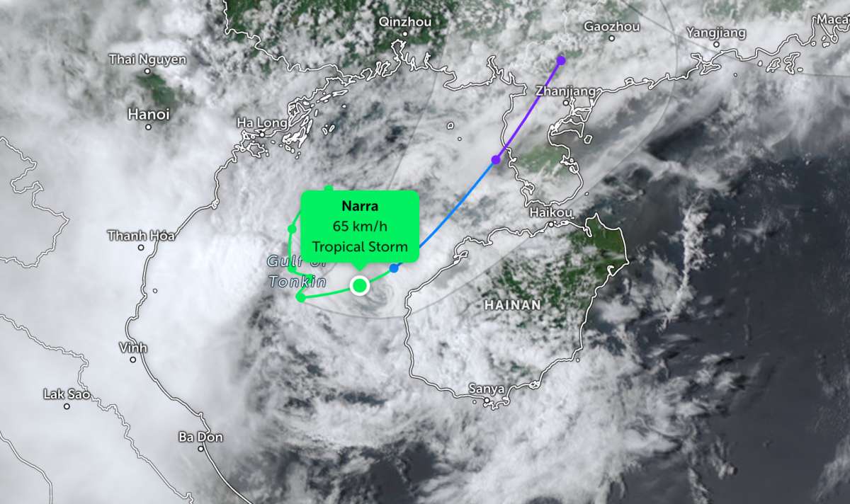
The strongest wind near the storm center is strong at level 8, from 62-74 km/h, gusting at level 10. The storm moves in the East direction at a speed of 5-10 km/h.
It is forecasted that by 1:00 PM on August 26th, the storm will move in a Northeast direction at a speed of about 10 km/h. The storm's center is located at about 21.3 degrees North latitude - 110.1 degrees East longitude, on land north of Leizhou Peninsula (China).
The storm gradually weakens into a tropical depression, wind force level 7, gusts level 9. Disaster risk level: level 3 is warned in the Gulf of Tonkin area, including Bach Long Vi special zone.
Due to the impact of the storm, the Gulf of Tonkin area (including Bach Long Vi special zone) has strong winds of level 6-7, the area near the storm center passing through is strong at level 8, gusting at level 10, sea waves are 2.0-4.0m high; strong sea waves.
Ships operating in the above-mentioned dangerous areas are likely to be affected by thunderstorms, tornadoes, strong winds, and large waves.
On land, on August 25, the Nghe An, Ha Tinh and northern Quang Tri areas will have scattered showers and thunderstorms with rainfall of 10-25mm, locally heavy rain over 50mm.
In the evening and night of August 25, the North and Thanh Hoa will have showers and scattered thunderstorms with rainfall of 15-35mm, locally heavy rain over 80mm. In thunderstorms, there is a possibility of tornadoes, lightning, hail and strong gusts of wind.
People and tourists in the coastal area of the Northern region should pay close attention to weather forecasts. Follow local instructions and avoid going to sea when the sea is rough to ensure safety throughout the journey.


