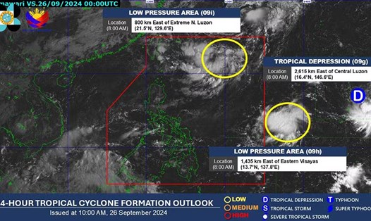
A low pressure area strengthened into a tropical depression early on September 27. PAGASA named the tropical depression “Julian.”
The center of the tropical depression was recorded about 525 km east of Itbayat, Batanes, and has not moved much. Currently, the maximum sustained winds are 55 km/h and gusts up to 70 km/h.
“The tropical depression is forecast to continue to intensify throughout the forecast period and may reach tropical storm status by the evening of September 27 or the morning of September 28 (local time). Furthermore, it may become a typhoon by September 29,” PAGASA said in its weather forecast.
Tropical Depression Julian is forecast to bring partly cloudy skies with scattered showers and thunderstorms to Ilocos Norte, Apayao, Batanes, Cagayan (including Babuyan Islands) areas.
However, PAGASA has not yet issued any tornado warning.
Over the next five days, Tropical Depression Julian is forecast to move in a circular path over the seas east of Batanes and Cagayan, Philippines.
PAGASA warned that rough seas will occur in Batanes, Babuyan Islands and the east coast of mainland Cagayan.
“Small seagoing vessels, including all types of motor boats, are advised not to venture out to sea in these conditions, especially if they are inexperienced or are operating an ill-equipped vessel,” PAGASA said.
Crews in other areas of Cagayan and Isabela are also advised to exercise caution, as seas in these areas will be moderate.
If this tropical depression becomes a storm, it will be the sixth storm in the Philippines in September alone. It could strengthen into a strong typhoon by October 1.
Although the tropical depression is not forecast to develop into a serious problem, tourists planning to visit the Philippines and neighboring areas in the next few days are advised to monitor weather forecasts. At the same time, update announcements from airlines and related service providers to adjust their schedules promptly when necessary.


