Today (September 19), the mountainous and midland areas of the North and South will have scattered showers and thunderstorms, with some places having heavy rain. Rainfall from 7am to 3pm on July 19th was over 50mm at monitoring stations such as: Thi Hoa station (Cao Bang) 53.9mm; Tan Phuong station (Yen Bai) 51.2mm; Thanh Dong station (An Giang) 60.2mm.
In the Northern region in the evening and night of July 19, there is a forecast of showers and scattered thunderstorms, locally heavy rain in mountainous and midland areas with rainfall from 15 - 30mm, locally over 70mm.
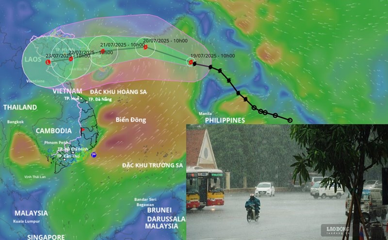
From the afternoon of July 21 to July 23, due to the impact of storm No. 3 Wipha, the Northern and North Central regions are likely to experience a widespread heavy rain with common rainfall of 100 - 200mm, locally over 300mm.
In particular, the Northeast region, the Northern Delta, Thanh Hoa and Nghe An will have heavy to very heavy rain with common rainfall of 200 - 350mm, locally over 600mm.
According to the meteorological agency, the provinces of Quang Ninh, Hai Phong, coastal provinces of Hung Yen, Ninh Binh, Thanh Hoa are forecast to be affected by the strongest storm. Warning of the risk of heavy rain over 150mm in 3 hours.
According to the meteorological agency, the western edge of the storm's circulation may cause thunderstorms before the storm on our mainland from tomorrow evening and night, July 20.
In the Central and Southern Plateau in the evening and night of July 19, there is a forecast of showers and scattered thunderstorms, locally heavy rain with rainfall from 10 - 30mm, locally over 60mm.
During thunderstorms, there is a possibility of tornadoes, lightning, hail and strong gusts of wind. Localized heavy rains are likely to cause flash floods on small rivers and streams, landslides on steep slopes and flooding in low-lying areas.