Early this morning, July 20, the National Center for Hydro-Meteorological Forecasting issued an emergency storm notice - storm No. 3 Wipha.
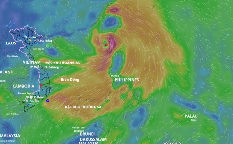
Updated from the meteorological agency, at 4:00 a.m. on July 20, the center of storm No. 3 Wipha was at about 21.6 degrees north latitude; 115.4 degrees east longitude, in the northern sea area of the North East Sea, about 830km east of Quang Ninh - Hai Phong.
The strongest wind near the storm center is level 11 (103-117km/h), gusting to level 14. The storm is moving west-northwest at a speed of about 20-25km/h.
Storm heading towards the sea area of Quang Ninh - Ninh Binh in the next 48 hours
It is forecasted that in the next 24 hours, the storm will move mainly westward, traveling 20 - 25km per hour and is likely to strengthen. At 4:00 a.m. on July 21, the center of the storm was at about 21.3 degrees north latitude; 110.3 degrees east longitude, on the mainland northeast of the Lusian Peninsula (China). The strongest wind near the storm center is level 11-12, gusting to level 15.
The dangerous area is determined to be north of 20 degrees north latitude; within the range of 108.5 to 117.5 degrees east longitude. Level 3 natural disaster risk, the affected area is the northern sea area of the northern East Sea.
It is forecasted that in the next 48 hours, the storm will move west-southwest at a speed of about 15km/h. At 4:00 a.m. on July 22, the center of the storm was at about 20.6 degrees north latitude; 107.4 degrees east longitude, in the waters of Quang Ninh - Ninh Binh. The strongest wind near the storm center is level 10-11, gusting to level 14. Natural disaster risk level 3.
It is forecasted that in the next 72 hours, the storm will continue to move west-southwest at a speed of about 10km/h, entering the mainland of the Northern Delta and Thanh Hoa, gradually weakening into a tropical depression.
At 4:00 a.m. on July 23, the center of the tropical depression was at about 20.2 degrees north latitude; 105.0 degrees east longitude. The strongest wind is level 6, gusting to level 8. Natural disaster risk level 3.
From July 21, the storm will have a strong impact on the mainland
Regarding the impact of the storm at sea, the sea area north of the northern East Sea will have strong winds of level 8-10, near the center of the storm level 11-12, gusts of level 15; waves 5-7m high, the sea will be very rough.
From the night of July 20, the sea area north of the Gulf of Tonkin (including Bach Long Vi, Co To, Cat Hai) will gradually increase to level 6-7, then increase to level 8-9, near the storm center level 10-11, gusts of level 14. The waves are 2.0-4.0m high, near the center 3.0-5.0m.
From July 21, the southern Gulf of Tonkin will have winds gradually increasing to level 6-7, near the storm center level 8-9, gusting to level 11; waves 2.0-4.0m high. The sea is very rough. Ship in the danger zone is at high risk of being affected by thunderstorms, whirlwinds, strong winds, and large waves.
Regarding the situation of storm surge, the coastal areas of Quang Ninh - Hai Phong have storm surge water from 0.5 - 0.8m high, combined with tides creating a total water level of 4.1m high at Hon Dau (Hai Phong) to 5m at Bai Chay (Quang Ninh), causing flooding in low-lying coastal areas, river mouths at noon and afternoon of July 22.
On land, from the evening and night of July 21, coastal areas from Quang Ninh to Thanh Hoa will have winds gradually increasing to level 7-9, gusting to level 10-11; deep inland, strong winds of level 6-7, gusting to level 8-9; near the storm center, level 10-11, gusting to level 14.
From July 21 to 23, the North and North Central regions will have widespread heavy rain with common rainfall of 100-200mm, some places over 300mm; in the Northeast region, the Northern Delta, Thanh Hoa and Nghe An, there will be heavy to very heavy rain, common rainfall of 200-350mm, some places over 600mm. Warning of a high risk of heavy rain over 150mm/3 hours.