According to Mr. Mai Van Khiem - Director of the National Center for Hydro-Meteorological Forecasting, at 7:00 a.m. on July 19, the center of storm No. 3 Wipha was at about 20 degrees north latitude; 119.8 degrees east longitude, in the northeastern sea area of the northern East Sea. The strongest wind near the storm center is level 9 (75-88km/h), gusting to level 12. The storm is moving northwest at a speed of about 20km/h.

"It is forecasted that in the next 24 hours, the storm will move west-northwest at a speed of about 20km/h, moving deep into the East Sea and continuing to strengthen" - Mr. Khiem said.
At 7:00 a.m. on July 20, the center of the storm was at about 21.8 degrees north latitude; 115.7 degrees east longitude, in the northern sea area of the northern East Sea, about 600km east of the Lusian Peninsula (China). The strongest wind near the storm center is level 10-11, gusting to level 13.
The danger zone is determined from latitude 18 to 23 degrees north; east of longitude 114.5 degrees east. Level 3 natural disaster risk, the affected area is the eastern sea area of the northern East Sea.
It is forecasted that in the next 48 hours, the storm will move mainly west at a speed of about 20km/h.
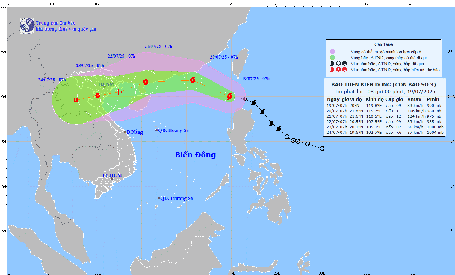
At 7:00 a.m. on July 21, the center of the storm was at about 21.6 degrees north latitude; 110.5 degrees east longitude, on the east coast of Zhou Peninsula (China).
"When in the east of the Lusian Peninsula (China), the storm will have the strongest intensity with strong winds near the storm center at level 11 - 12, gusting to level 14" - Mr. Khiem said.
The dangerous area in the next 48 hours will be determined to be north of latitude 19.5 degrees north; east of longitude 108.5 degrees east. Level 3 natural disaster risk, the affected area is the sea area north of the northern East Sea and the sea area east of the Gulf of Tonkin.
According to Mr. Khiem, it is forecasted that in the next 72 hours, the storm will move west-southwest at a speed of about 20km/h and gradually weaken.
At 7:00 a.m. on July 22, the center of the storm was at about 20.5 degrees north latitude; 107.5 degrees east longitude, in the Gulf of Tonkin. The strongest wind near the storm center is level 9, gusting to level 12. The dangerous area in the East Sea is identified as being north of latitude 19.5 degrees north; west of longitude 112.5 degrees east. Level 3 natural disaster risk, the affected area is the northwest sea area of the northern East Sea and Gulf of Tonkin.
From the next 72 to 120 hours, the storm will move mainly in the west-southwest direction, traveling 10 - 15km per hour and continuing to weaken.
Regarding the impact of storms at sea, according to the Director of the Meteorological Agency, it is necessary to pay attention to the sea area east of the northern East Sea with winds gradually increasing to level 6 - 7, the area near the storm's eye has strong winds of level 8 - 9, then increasing to level 10-11, gusts of level; waves 4 - 6m high, and rough seas.
Ship operating in the danger zone are likely to be affected by thunderstorms, whirlwinds, strong winds and large waves.
On land, regarding the forecast of rain, from the afternoon of July 20, the storm may have thunderstorms in the western circulation of the storm. From July 21 to 24, the storm may cause widespread rain in the North and North North Central regions.
"The affected area is forecast to be from Quang Ninh to Nghe An. However, this is a preliminary assessment and needs to be updated further," said Mr. Khiem.
Rainfall and rainfall distribution depend on the movement direction of storm No. 3, specifically updated in the emergency storm bulletin on July 20.