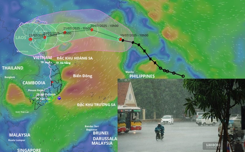
According to the National Center for Hydro-Meteorological Forecasting, at 1:00 p.m. on July 19, the center of storm No. 3 Wipha was at about 20.5 degrees north latitude; 119 degrees east longitude, in the northeastern sea area of the northern East Sea. The strongest wind near the storm center is level 9 - 10 (75 - 102km/h), gusting to level 12. The storm is moving northwest at a speed of about 20km/h.
It is forecasted that in the next 24 hours, the storm will move west-northwest at a speed of 20 - 25km/h and is likely to strengthen. At 1:00 p.m. on July 20, the center of the storm was at about 21.8 degrees north latitude; 113.7 degrees east longitude, in the northern sea area of the northern East Sea, about 370km east of the Lusian Peninsula (China).
The strongest wind near the storm center is level 11 - 12, gusting to level 15. The danger zone is determined to be from 18.5 to 23 degrees north latitude, east of 112 degrees east longitude. Level 3 natural disaster risk, the affected area is the northern sea area of the northern East Sea.
It is forecasted that in the next 48 hours, the storm will move west-southwest at a speed of 15 - 20km/h. At 1:00 p.m. on July 21, the center of the storm was at about 21.2 degrees north latitude; 109.6 degrees east longitude, on the west coast of Zhou Peninsula (China).
The strongest wind near the storm center is level 10 - 11, gusting to level 13. The danger zone is identified as being 19.5 degrees north latitude north of the equator, within the range of 108 to 116 degrees east longitude. Level 3 natural disaster risk, the affected area is the sea area north of the northern East Sea and the sea area east of the northern Gulf of Tonkin.
It is forecasted that in the next 72 hours, the storm will move west-southwest at a speed of 10 - 15km/h and continue to weaken. At 1:00 p.m. on July 22, the center of the storm was at about 20.5 degrees north latitude; 106.3 degrees east longitude, on the mainland of the Northern Delta and Thanh Hoa.
The strongest wind near the storm center is level 8, gusting to level 10. The dangerous area in the East Sea is determined to be north of latitude 19 degrees north, west of longitude 111.5 degrees east. Level 3 natural disaster risk, the affected area is the northwest sea area of the northern East Sea and the Gulf of Tonkin.
From the next 72 to 96 hours, the storm will move mainly in the west-southwest direction, traveling 5 - 10km per hour and continuing to weaken.
Forecast of the impact of the storm, in the northern sea area of the northern East Sea, there will be strong winds of level 8 - 10, near the storm's eye level 11 - 12, gusting to level 15. Waves are 4 - 6m high. The sea is rough. Ship operating in dangerous areas are likely to be affected by thunderstorms, whirlwinds, strong winds and large waves.