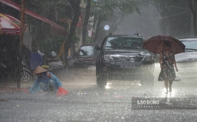
At around 1:45 p.m. on July 19, the QN - 7105 tourist ship unfortunately capsized due to a thunderstorm in the area near Dau Go cave, Ha Long Bay.
As of this morning, July 20, according to police data, the total number of people on the boat was 49, including 46 passengers and 3 crew members. Thus, with 35 bodies found, along with 10 people saved, there are currently 4 people missing.
This serious incident raises many questions related to natural disaster forecasting and warning, especially the thunderstorm phenomenon on July 19 in Quang Ninh province.
The latest discussion at 10:00 a.m. on July 20 by Lao Dong Newspaper reporter with Mr. Pham The The - Director of Quang Ninh Province Hydrometeorological Station clarified the issuance of forecasts warning about dangerous phenomena on July 19.
"Regarding the 24/24 weather monitoring process, when detecting thunderstorms and unusually dangerous weather, the Quang Ninh Provincial Hydrometeorological Station immediately issued warnings and sent them to competent authorities according to regulations, to implement direction and response plans" - Mr. The said.
These reports all warn that during thunderstorms, it is necessary to be on guard against dangerous weather phenomena such as lightning, tornadoes, strong gusts of wind and landslides, which can break trees, damage houses, traffic works, infrastructure and endanger people's lives. The warning level of natural disaster risk due to tornadoes, lightning, and hail is level 1.
Requesting agencies, units and people in affected areas to pay attention to monitoring and proactively preventing to ensure safety.
Agencies and units receiving warning bulletins on September 19:
- Quang Ninh Provincial Party Committee Office
- People's Committee of Quang Ninh province
- Quang Ninh Maritime Port Authority
- Quang Ninh Inland Waterway Port
- Quang Ninh Newspaper
- Command Committee for Natural Disaster Prevention - Search and Rescue and Civil Defense
Warning bulletins and weather forecasts are issued as follows:
- 15:30 afternoon of 18.7:
The Quang Ninh Provincial Hydrometeorological Station issued a forecast bulletin and a hydrological warning for up to 10 days. Accordingly, the Gulf of Tonkin sea area. In particular, there is a forecast for Bai Chay sea area, including the sea area of Ha Long Bay, to have rain in some places during the day, showers and thunderstorms at night, and a rough sea forecast.
- 4:30 a.m. on September 19:
The National Center for Hydro-Meteorological Forecasting issued a sea weather forecast for the day and night of July 19. The bulletin forecasts that the Gulf of Tonkin will have scattered showers and thunderstorms during the day; and scattered showers and thunderstorms at night. During thunderstorms, there is a possibility of tornadoes and strong gusts of wind.
- 11:45 on September 19:
The Quang Ninh Provincial Hydrometeorological Station issued a warning bulletin of thunderstorms, tornadoes, lightning, hail and local heavy rain in Quang Ninh.
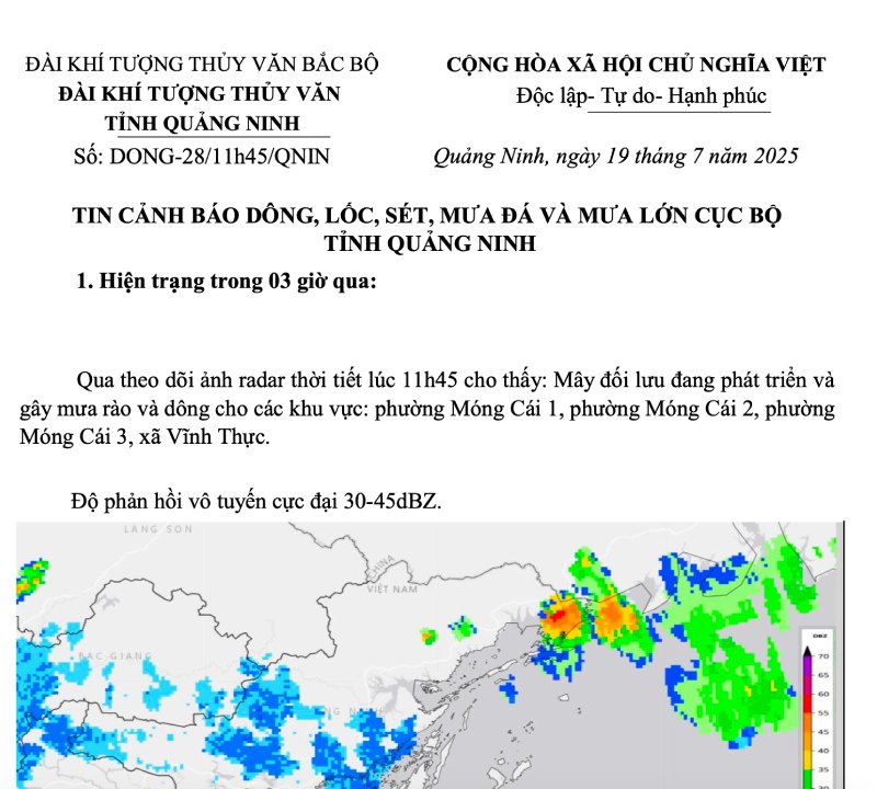
The news report stated that in the past 3 hours, monitoring weather radar images at 11:45 showed that convective clouds were developing and causing showers and thunderstorms in Mong Cai 1 ward, Mong Cai 2 ward, Mong Cai 3 ward, Vinh Thuc commune. Maximum radio responsiveness reaches 30 to 45dBZ.
In the current period and in the next few hours, convective clouds will continue to cause showers and thunderstorms in the above areas. After that, the thunderstorm area is likely to expand, spreading to the areas of Quang Ha commune, Duong Hoa commune, Quang Duc commune, Hai Son commune, Hai Ninh commune, Dam Ha commune, Cai Chien commune, Hoanh Mo commune ward, Luc Hon commune, Binh Lieu commune, Dien Xa commune, Tien Yen commune, Dong Ngu commune, Hai Lang commune, Quang Tan commune, Hai Hoa commune and neighboring commune wards.
- 1:30 p.m. on September 19:
The Quang Ninh Provincial Hydrometeorological Station continues to issue warning bulletins of thunderstorms, tornadoes, lightning, hail and local heavy rain.

In the past 3 hours, in An Sinh, Dong Trieu, Binh Khe, and Mao Khe wards (Quang Ninh), through weather radar monitoring at 1:30 p.m., convective clouds are developing and causing showers and thunderstorms, with heavy rain in some areas: Mong Cai 1, Mong Cai 2, Mong Cai 3, Vinh Thuc, Hoanh Mo commune, Luc Hon commune, Binh Lieu commune, Dien Xa commune, Tien Yen commune, Dong Ngu commune, Hai Lang commune, Quang Tan commune, Hai Hoa commune, Hoanh Bo ward, Quang La commune, Thong Nhat commune, Mong Duong ward, Quang Hanh ward, Cam Pha ward, Cua Ong ward, Tuan Chau ward, Hung Viet, Tu Hai pha ward, Ha Pham ward, Ha Pham ward, Ha Xanh ward, Ha Dong, Ha Trang commune, Ha Trang ward, Ha Trang ward, Ha Trang ward, Ha Trang ward, Ha Trang ward, Ha Trang ward, Ha Trang ward. The maximum radio responsiveness was recorded at 30-45dBZ.
In the next few hours, convective clouds will continue to cause showers and thunderstorms in the above areas. After that, thunderstorms are likely to spread to the areas of Dong Mai, Hiep Hoa, Quang Yen, Ha An, Phong Coc, Lien Hoa, Yen Tu, Vang Danh, Uong Bi, Hoang Que, An Sinh, Dong Trieu, Binh Khe, Mao Khe wards and neighboring wards and communes.
Previously, on the night of July 19, the Department of Hydrometeorology responded regarding forecasting and warning work. Accordingly, this unit has directed its affiliated units to ensure a monitoring and communication system to serve the forecasting and warning of tropical depressions/storm, strong winds, big waves and accompanying natural disasters.
Specifically, the Department of Hydrometeorology has directed the National Center for Hydro-Meteorological Forecasting and the Northern Hydrometeorological Station to focus on closely monitoring the developments of tropical depressions/stormations and accompanying natural disasters; updating, providing full and timely disaster forecasts and impact forecasts to the Civil Defense Steering Committees at all levels, relevant agencies and people to proactively prevent, transmit diverse information on digital technology platforms and provide timely information to media agencies in accordance with regulations.
The Center for Hydrometeorological Information and Data ensures a stable operating equipment system, fully and promptly meeting information and data requirements for meteorological forecasting and warning.