This afternoon, July 19, Mr. Hoang Phuc Lam - Deputy Director of the National Center for Hydro-Meteorological Forecasting, Department of Hydro-Meteorology provided the latest comments on storm No. 3 Wipha.

Sir, what is the forecast for the current intensity of storm No. 3 Wipha after entering the East Sea?
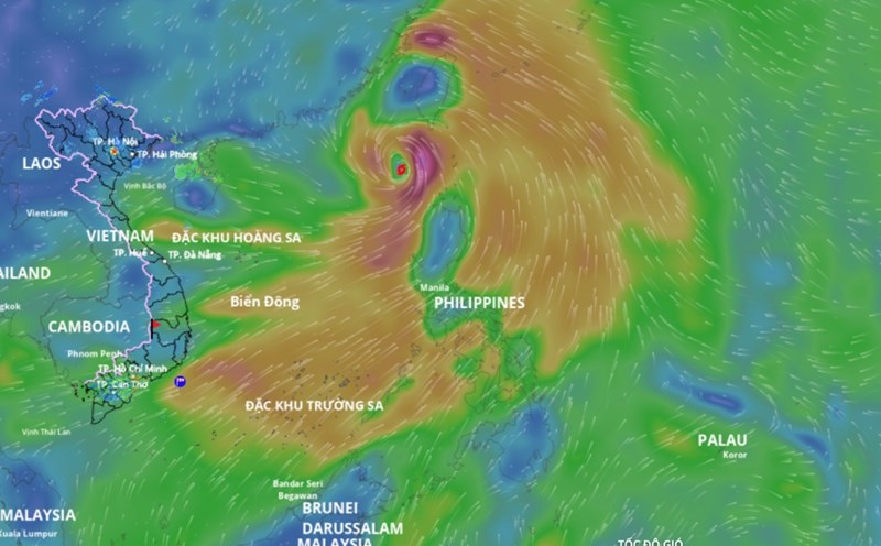
- Typhoon Wipha is the 6th storm in the Northwest Pacific and the 3rd storm in the East Sea. Currently, the storm is strong at level 9, increasing to level 1 in the past 24 hours. Currently, the center of the storm is located about 1,000km east of Zhejiang Peninsula (China).
Storm No. 3 with the strongest intensity can reach level 12 - 13, gusting to level 14 - 15 when in the eastern area of Lusi Peninsula (China), moving on mainland China, weakening rapidly; entering the Gulf of Tonkin, the intensity is about level 8 - 10.
What characteristics of this storm fund need to be noted, sir?
- We consider this a strong storm, moving rapidly at a speed of about 20km/h. The circulation causes rain to shift to the South and the West. Therefore, thunderstorms before the storm may occur as early as July 20 - 21 - when the storm is still outside the Gulf of Tonkin and east of the Lusian Peninsula (China).
With such assessments of trajectory and intensity, what is the forecast of the impact that needs attention of this storm and which area is most affected, sir?
- The biggest and most dangerous risk in the next 24 hours is strong winds and big waves in the northern and central areas of the East Sea (the sea area of Hoang Sa special zone); the northern sea area of the North East Sea is where the storm passes, with wind intensity of level 10 - 12, gusts of level 15, waves 3 - 5m high, near the storm's center 4 - 6m.
From around July 20 to 21, the special areas of Bach Long Vi, Co To, Cat Hai... are likely to be greatly affected by strong winds and heavy rain due to storm No. 3.
Around early morning and on July 22, the storm affected our mainland. The coastal waters from Quang Ninh to Thanh Hoa will begin to be directly affected by strong winds, heavy rain and rising water with strong winds of level 7 - 9, waves 3 - 5m high.
High waves combined with high tides can cause flooding in low-lying areas in the coastal areas of Quang Ninh - Hai Phong (from noon and afternoon of July 21 to 23.
On land, the scope of influence of storm No. 3 is wide, mostly throughout the Northeast region, some places in the Northwest, North Central provinces. The storm directly affected the provinces of Quang Ninh, Hai Phong, and the coastal provinces of Hung Yen, Ninh Binh, and Thanh Hoa. These provinces are forecast to be most affected by strongest storms.
Storm No. 3 is forecast to cause widespread heavy rain in the North and the provinces of Thanh Hoa - Ha Tinh; in which the midlands and the Northern Delta, Thanh Hoa, Nghe An, will have rain from July 21 to 24. Some places will have local heavy rain with rainfall over 150mm/3 hours;
From July 21 to 24, on rivers in the North, Thanh Hoa, Nghe An, there is a possibility of a flood, with a flood amplitude of 3 - 6m.
There is a high risk of flooding in low-lying areas along rivers, urban areas, and densely populated areas. Flash floods and landslides on steep slopes in the mountainous areas of the North and Thanh Hoa and Nghe An.
Sincerely thank you!