Latest update from the National Center for Hydro-Meteorological Forecasting, at 4:00 p.m. on July 20, the center of storm No. 3 Wipha was at about 21.8 degrees north latitude; 112.8 degrees east longitude, in the northern sea area of the North East Sea, about 560 km east of Quang Ninh - Hai Phong.
The strongest wind near the storm center is level 12 (118-133 km/h), gusting to level 15. The storm is moving westward at a speed of about 20-25 km/h.
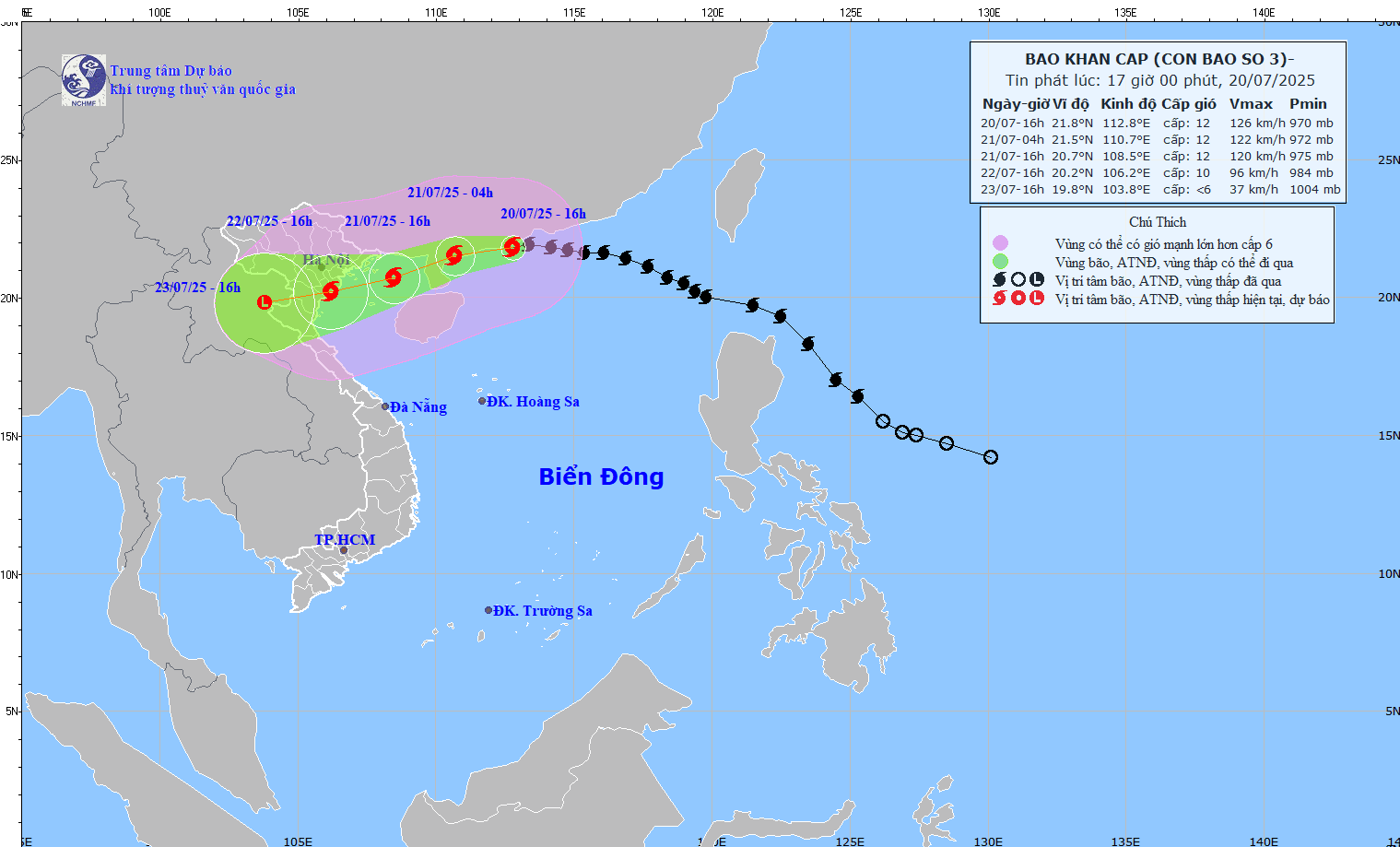
The storm may be as strong as level 9-10, gusting to level 12 when making landfall
It is forecasted that in the next 24 hours, the storm will move west-southwest at a speed of 20-25 km/h. At 4:00 p.m. on July 21, the center of the storm was at about 20.7 degrees north latitude; 108.5 degrees east longitude, in the northern area of the Gulf of Tonkin. The strongest wind near the storm center is level 11-12, gusting to level 15.
The danger zone is identified as being north of 19 degrees north latitude; from 107.5 degrees east longitude to 115.5 degrees east longitude. Level 3 natural disaster risk for the northwestern sea area of the northern East Sea, the northern area of the Gulf of Tonkin.
It is forecasted that in the next 48 hours, the storm will continue to move west-southwest at a speed of 10-15 km/h. At 4:00 p.m. on July 22, the center of the storm was at about 20.2 degrees north latitude; 106.2 degrees east longitude, on the mainland along the coast of Hai Phong - Thanh Hoa provinces. The strongest wind near the storm center is level 9-10, gusting to level 12.
The danger zone is identified as 18 degrees north latitude north of the north; 110.5 degrees east longitude west of the east. Level 3 natural disaster risk for the northwestern sea area of the northern East Sea, the Gulf of Tonkin, and coastal waters of provinces from Quang Ninh to Nghe An.
It is forecasted that in the next 72 hours, the storm will move west-southwest at a speed of 10-15 km/h and gradually weaken into a low pressure area. At 4:00 p.m. on July 23, the center of the low pressure area was at about 19.8 degrees north latitude; 103.8 degrees east longitude, on the mainland of upper Laos. Wind power below level 6.
The dangerous area at sea is north of the 18-degree north latitude; west of the 108-degree east longitude. Level 3 natural disaster risk for the Gulf of Tonkin, coastal waters and mainland provinces from Quang Ninh to Nghe An.
Extremely dangerous weather and hydrological conditions
Forecast of the impact of the storm at sea, the northwestern sea area of the northern East Sea will have strong winds of level 8-10, the area near the storm's eye will have winds of level 11-12, gusting to level 15. Waves are 5-7 m high, the sea is rough.
From the night of July 20, the northern sea area of the Gulf of Tonkin (including the special areas of Bach Long Vi, Co To, Cat Hai, Hon Dau island) will have winds gradually increasing to level 6-7, then increasing to level 8-9, the area near the storm center will have level 10-12, gusting to level 15. Waves 2-4 m high, near the center of the storm 3-5 m, the sea is rough.
The southern sea area of the Gulf of Tonkin (including Hon Ngu island) will have winds gradually increasing to level 6-7, near the storm center level 8-9, gusting to level 11. Waves are 2-4 m high, the sea is very rough.
Weather and hydrological conditions are extremely dangerous and unsafe for any means of transport operating at sea, including tourist boats, passenger ships and transport ships. It is possible to capsize boats, damage cages, and threaten the lives of fishermen if they are still operating at sea.
The coastal area of Hai Phong - Quang Ninh has storm surge water from 0.8-1.2 m. The water level at Hon Dau (Hai Phong) is 3.8-4.2 m high, at Cua Ong (Quang Ninh) is 4.8-5.2 m high and at Tra Co (Quang Ninh) is 3.8-4.4 m high. There is a high risk of flooding in coastal areas and river mouths at noon and afternoon of July 22.
On land, from the evening and night of July 21, coastal areas from Quang Ninh to Nghe An will have winds gradually increasing to level 7-9, near the storm center level 10-11, gusting to level 14. The deep inland area has strong winds of level 6-7, gusting to level 8-9. Winds of level 10-11 can cause trees, electric poles to fall, and roofs to fall off, causing very heavy damage.
Regarding heavy rain, from July 21 to July 23, in the northeastern region, the northern plains of the Ministry, Thanh Hoa and Nghe An, there will be heavy to very heavy rain and thunderstorms with common rainfall of 200-350 mm, locally over 600 mm.
Other places in the northern region and Ha Tinh will have heavy rain, locally very heavy rain and thunderstorms with common rainfall of 100-200 mm, locally over 300 mm. Warning of the risk of heavy rain over 150 mm in 3 hours. Heavy rainfall in a short period of time can cause flash floods, landslides in mountainous areas, and flooding in low-lying areas.