Tonight (September 19), the National Center for Hydro-Meteorological Forecasting provided information to the press about the development of heavy rain in many localities in the North on the afternoon of July 19, especially in Quang Ninh.
Storm No. 3 has not directly affected the Gulf of Tonkin
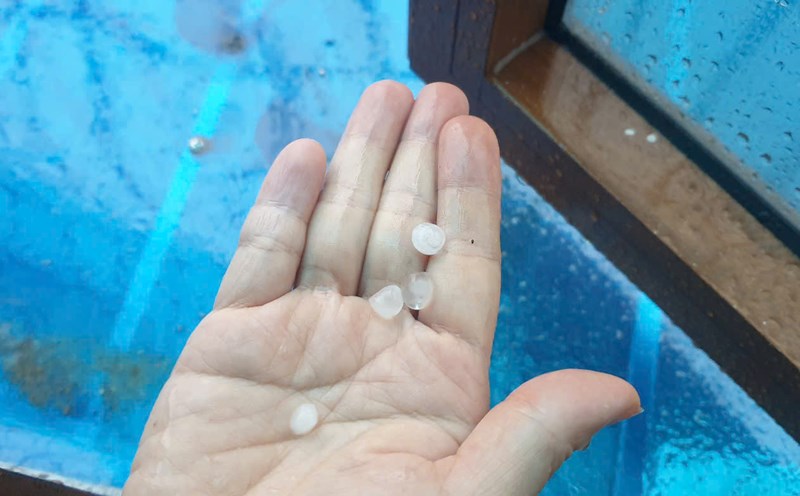
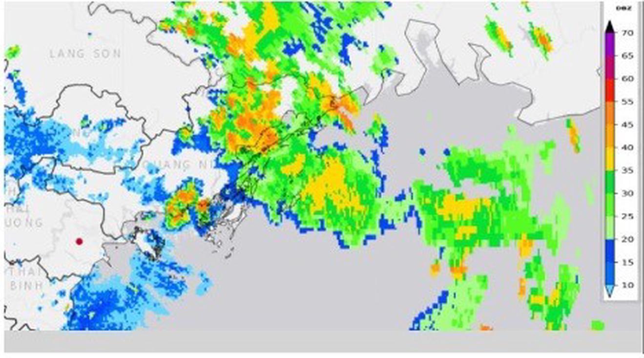
Accordingly, on the afternoon of July 19, the Northern region experienced widespread thunderstorms, many places had strong thunderstorms, tornadoes and strong gusts of wind, locally heavy to very heavy rain. Some places have strong gusts such as: Cua Ong station (Quang Ninh) 16m/s (level 7), Bai Chay station (Quang Ninh) 26m/s (level 10), Bach Long Vi station (Hai Phong) gusts 18m/s (level 8)...
The meteorological agency emphasized that on the afternoon of July 19, the center of storm No. 3 Wipha was at about 20.7 degrees North latitude; 118.4 degrees East longitude, (over 1,000km east of Ha Long Bay); the storm's circulation was about 200 - 300km (calculated from the center of the storm). The strongest wind near the center of the storm is level 10 (89-102km/h), gusting to level 12 and has not directly affected the Gulf of Tonkin.
The cause of this afternoon's strong thunderstorms in the North and Gulf of Tonkin is the influence of the tropical convergence zone with an axis passing through the Northern region, combined with the temperature conditions in the Northern region increasing in the past 3 days, causing a strong increase in the unstable conditions of the atmosphere, causing strong thunderstorms.
This is a tropical super typhoon system (Mesoscale Convective systems - MCSs in the tropics) which is a medium-sized combination of thunderstorms, often causing very heavy rain accompanied by dangerous weather phenomena.
The super typhoon system has a diameter of several kilometers to several hundred kilometers. Including many clusters of developed thunderstorms combined into a large system. It can last for many hours, even 12 - 24 hours, stronger and longer than a single thunderstorm.
Forecast and warning of thunderstorms this afternoon
Previously, in Quang Ninh, on the afternoon of July 19, the QN 7105 ship, while traveling on Ha Long Bay, was suddenly capsized due to a thunderstorm. There were 48 passengers and 5 crew members on board. The location was determined to be between Hon Ga Choi and Bai Tho Mountain (about 3 nautical miles from the mainland).
The ship capsized causing many casualties, causing some people to question the forecasting and warning of thunderstorms this afternoon in the North, including Ha Long Bay and Quang Ninh.
Regarding information that people are wondering, the National Center for Hydro-Meteorological Forecasting said that at 11:45 a.m. on July 19, the Quang Ninh Provincial Hydro-Meteorological Station issued a warning bulletin of thunderstorms, tornadoes, lightning, hail and local heavy rain in Quang Ninh province.
The content of the warning bulletin during thunderstorms should be on guard against lightning, tornadoes, strong gusts of wind and landslides that can break trees, damage houses, traffic works, infrastructure and endanger human life.
At 1:30 p.m., the Quang Ninh Provincial Hydrometeorological Station continued to issue a warning bulletin of thunderstorms, tornadoes, lightning, hail and local heavy rain in Quang Ninh province, including Ha Long ward.
Previously, in the sea weather forecast for the day and night of July 19 in 2025 (issued at 4:30), the National Center for Hydro-Meteorological Forecasting forecasted that the Gulf of Tonkin will have scattered showers and thunderstorms during the day; scattered showers and thunderstorms at night. During thunderstorms, there is a possibility of tornadoes and strong gusts of wind.
In the forecast bulletin, the hydrological warning for up to 10 days issued at 3:30 p.m. on July 18, the Quang Ninh Provincial Hydrometeorological Station also forecasted for July 19 in the Gulf of Tonkin sea area. In particular, there is a forecast for Bai Chay sea area, including the sea area of Ha Long Bay, to have rain in some places during the day, showers and thunderstorms at night, and a rough sea forecast.
Assessment of upcoming marine weather
Due to the influence of storm No. 3, from the night of July 19 and July 20, the Gulf of Tonkin, the North and the middle of the East Sea (including the special waters of Hoang Sa) will have showers and thunderstorms, especially the northern waters of the North East Sea will have storms, the Gulf of Thailand will have scattered showers and thunderstorms.
From the night of July 20 and July 21, the sea area north of the North East Sea will have strong winds of level 8-9, near the center of the storm will have winds of level 10-12, gusts of level 15; waves 4-6m high; the sea will be very rough.
The eastern sea area of the North Gulf of Tonkin from July 21 will have winds gradually increasing to level 6-7, then increasing to level 8-9, near the storm center level 10-11, gusting to level2; waves 2-4m high, near the center 3-5m; the sea is very rough.