The latest storm/low pressure information from the Philippines and the US Joint Typhoon Warning Center (JTWC) said that on the evening of November 11, a low pressure area marked 91W formed in southeastern Mindanao, outside the Philippine Forecast Area (PAR).
Currently, the possibility of this low pressure strengthening into a storm is low, but the low pressure may enter PAR and approach the eastern part of Visayas and Mindanao, then enter the East Sea from now until November 17, towards the coast of Vietnam.
The depression emerged after Typhoon No. 14 Fung-wong devastated the Philippines, killing at least 18 people and injuring 28.
According to the latest storm information from the Vietnam National Center for Hydro-Meteorological Forecasting, at 4:00 a.m. on November 12, the center of storm No. 14 was at about 21.3 degrees north latitude; 119.3 degrees east longitude, in the northeastern sea of the northern East Sea.
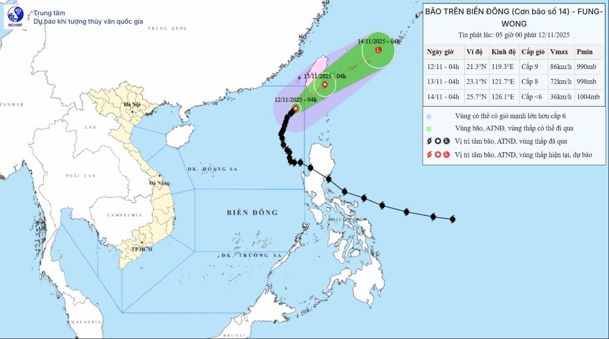
The strongest wind near the storm center is level 9 (75-88 km/h), gusting to level 11. The storm is moving northeast at a speed of 10-15 km/h.
At 4:00 a.m. on November 13, the center of the storm was at 23.1 degrees north latitude, 121.7 degrees east longitude; in the eastern sea of Taiwan (China), it gradually weakened, level 8, gust level 10, moving northeast, 10-15 km/h.
At 4:00 a.m. on November 14, the center of the storm was at 25.7 degrees north latitude, 126.1 degrees east longitude; in the sea northeast of Taiwan (China), it gradually weakened, becoming a low pressure area, with an intensity below level 6, moving northeast at 20-25 km/h.
Due to the influence of the storm, the northeastern sea area of the northern East Sea will have strong winds of level 6-7; the area near the storm's center will have strong winds of level 8-9, gusts of level 11, waves 3.0-5.0m high, the area near the storm's center will have 5.0-4.0m. The sea is very rough.
All ships operating in the above dangerous areas are likely to be affected by thunderstorms, whirlwinds, strong winds, and large waves.
Regarding cold air, on November 11, the cold air is weakly strengthening to the south. At Bach Long Vy station, there are strong northeast winds of level 5, sometimes level 6, gusting to level 7.
Due to the influence of the cold air being continuously strengthened combined with the high-altitude phase, from November 13-15, in the Northern region, Thanh Hoa and Nghe An, there will be few clouds and sunny days.
During the days of November 13-15, the lowest temperature at night in the Northern region, Thanh Hoa and Nghe An will drop sharply, generally between 16-18 degrees Celsius, in the mountainous areas of the North, some places will be below 13 degrees Celsius. At night and early morning, the weather in these areas will turn cold, in the high mountains, some places will be very cold.


