In the context of many areas not recovering from the series of storms and earthquakes, the Philippine government urgently activated response measures to minimize damage.
The latest storm information from the Philippine Atmospheric, Geophysical and Astronomical Services Administration (PAGASA) said that at 4:00 a.m. on December 7, tropical depression Wilma accelerated slightly and was moving through Calbayog city (Samar).
The center of the tropical depression is at 12.2 degrees north latitude, 124.8 degrees east longitude, with the strongest winds of 45 km/h, gusting to 75 km/h, central pressure of 1004 hPa.
Wilma is moving west-northwest at 15 km/h. The strong wind radius extends up to 150km from the center, causing widespread impact even though the intensity is not too strong.
In the next 24 hours, the sea is forecast to be rough to rough. Waves can reach up to 5m in the Cagayan, Isabela, Aurora seas; north and east of Polillo; Camarines Norte.
Waves are 4.5 m high in eastern Batanes, Babuyan; northern Quezon; Catanduanes; northern Camarines Sur.
The authorities warned that all types of ships and all types of loads are dangerous when going out to sea. All crew members are required to anchor and seek safe shelter until the wind and waves subside.
Although Wilma has made landfall, PAGASA stressed that heavy rains and strong winds are possible in areas outside the landfall point and beyond the normal forecast range.
Today, Wilma is forecast to continue crossing Southern Luzon and the Visayas before reaching the Sulu Sea, then overflowing north of Palawan tomorrow (December 8).
The intensity is likely to remain at the tropical depression level throughout the journey. However, the possibility of weakening early into a low pressure area when encountering strong northeast monsoons cannot be ruled out.
On December 5, when Wilma approached, the Philippine government immediately activated emergency support measures. The Ministry of Social Welfare and Development expressed its gratitude to the Ministry of the Budget for disbursing 990 million pesos (nearly 17 million USD) from the Quick Response Fund.
This fund is used to supplement relief goods and provide emergency cash support to families affected by the recent series of natural disasters.
The money will be prioritized for Central Luzon, Calabarzon, Bicol, Western Visayas and Central Visayas - the places most severely affected by Hurricanes Tino, Uwan and currently Wilma.
Although Wilma is not as strong as a super typhoon, authorities have warned of a high risk of flash floods and landslides, especially as the ground has saturated with water after a series of recent storms.
Meanwhile, the Vietnam National Center for Hydro-Meteorological Forecasting said that by 1:00 a.m. on December 9, the tropical depression is expected to be at about 11.2 degrees north latitude, 117.5 degrees east longitude; in the eastern sea area of the central East Sea, about 350km east-southeast of Song Tu Tay Island, strong at level 6, gusting to level 8.
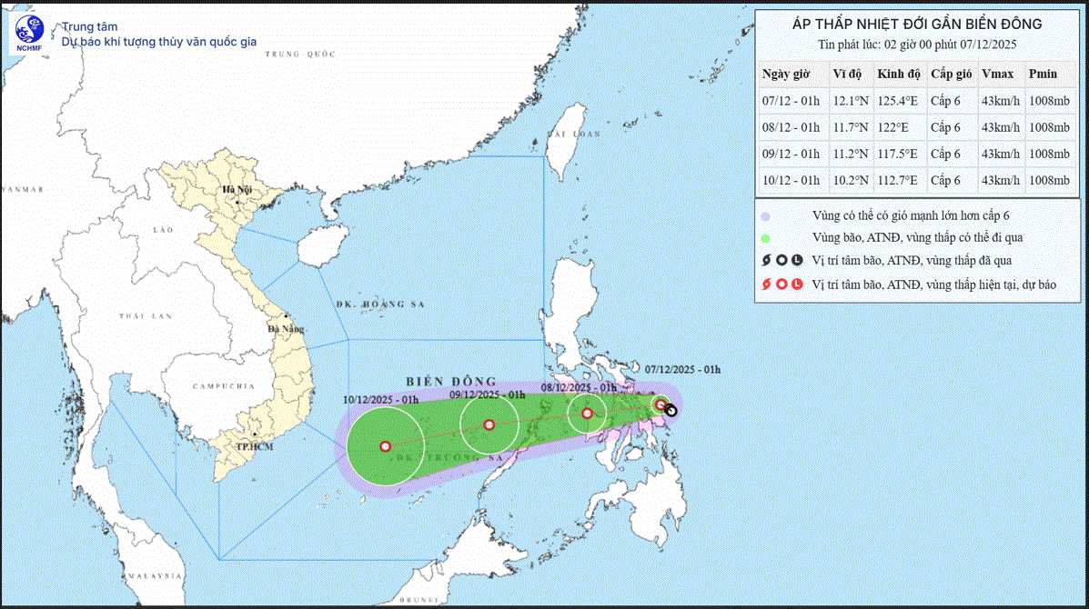
The tropical depression is moving west-southwest at about 20km/h. The level 3 disaster risk area is the sea area east of the central East Sea (including the sea area northeast of the Truong Sa special zone).
From the morning of December 8, the sea area east of the central East Sea (including the sea area northeast of Truong Sa) will have winds gradually increasing to level 6, gusting to level 8, waves 2-4m high, rough seas.
Ship in the danger zone may encounter thunderstorms, whirlwinds, strong winds, and large waves.


