The latest storm information from the Philippine Atmospheric, Geophysical and Astronomical Services Administration said that at 2:00 a.m. on December 2, the center of low pressure 12a was at about 12.6 degrees north latitude, 136.5 degrees east longitude, 1,290 km east of Eastern Visayas. The low pressure is likely to develop into a tropical depression within the next 24 hours.
According to PAGASA's typhoon forecast, one or two typhoons will form within or enter the Philippine Forecast Area (PAR) in December. The next two storms will be locally named Wilma and Yasmin.
PAGASA's forecast shows that Depression 12a - the predecessor of Wilma - may enter PAR as early as today (December 2) or December 3, then pass through the Caraga - Visayas - South Luzon area over the weekend.
Then, during the week of December 8-14, the low pressure is expected to move through Mindoro - Palawan, leave PAR and enter the East Sea, towards the South Central Coast of Vietnam.
Regarding storm No. 15, according to the Vietnam National Center for Hydro-Meteorological Forecasting, the storm has weakened into a tropical depression. At 1:00 a.m. on December 2, the center of the tropical depression was at 14.4 degrees north latitude, 111.2 degrees east longitude, in the northwest sea of the central East Sea. The strongest wind is level 6, gusting to level 8. Moving slowly in the south-southwest direction.
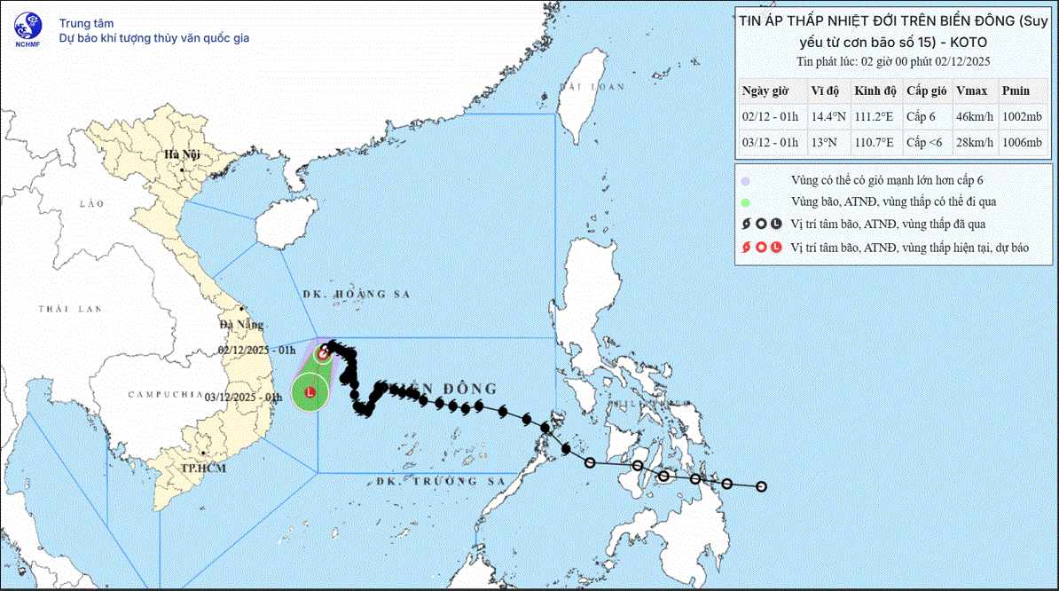
It is forecasted that by 1:00 a.m. on December 3, the center of the tropical depression will be at 13.0 degrees north latitude, 110.7 degrees east longitude; in the sea area of Dak Lak - Khanh Hoa province, gradually weakening into a low pressure area, with an intensity below level 6, moving south-southwest, 5-10 km/h.
The northwest sea area of the central East Sea, the sea area off the coast of Gia Lai - Dak Lak province is at risk of level 3 natural disasters.
The northwest sea area between the East Sea and the sea off the coast of Gia Lai - Dak Lak province has strong winds of level 6, gusts of level 8; waves 2.0-4.0m high, rough seas.
Ship operating in the above-mentioned dangerous areas are likely to be affected by thunderstorms, whirlwinds, strong winds, and large waves.


