The latest storm/low pressure information from the Philippine Atmospheric, Geophysical and Astronomical Services Administration (PAGASA) said that at 8:00 a.m. on December 7, tropical depression Wilma (12a) weakened into a low pressure area and was being monitored inside the Philippine Forecast Area (PAR), over the waters of Tagalpul-an, Samar. The center of the low pressure is located at about 12 degrees north latitude, 124.2 degrees east longitude.
Before that, after making landfall in Dolores, Eastern Samar, at 4:00 a.m. on December 7, tropical depression Wilma accelerated slightly, but after only a few hours it weakened into a low pressure area.
PAGASA weather forecaster Robert Badrina said that Typhoon Warning Signal No. 1 is still maintained over Sorsogon, Masbate, including the islands of Ticao and burias, Romblon, the southern part of Oriental Mindoro, the southern part of Western Mindoro, and the northernmost Palawan in Luzon.
On the Visayas, similar wind signals also appear on Northern Samar, northern and central parts of Eastern Samar, northern and central parts of Samar, Biliran, northern Leyte, northern Philippines including the Bantayan Islands, northern part of Negros Occidental, central and eastern parts of Iloilo, Capiz, Aklan, and northern and central parts of Antique, including the Caluya Islands.
According to PAGASA, the low pressure is moving west-northwest at a speed of 15 km/h, with maximum sustained winds of 45 km/h and gusts of 75 km/h.
According to Badrina's forecast, the low pressure is likely to move mainly west-southwest for most of the forecast period, continuing to pass through Southern Luzon and the Visayas before crossing the Sulu Sea and passing north of Palawan in the morning or afternoon of December 8.
PAGASA said the increasingly unfavorable environment caused by the northeast monsoon contributed to the tropical depression weakening rapidly into a depression.
There is currently no sign that this low pressure is likely to strengthen into storm No. 16 when it enters the East Sea.
Not to mention, when entering the East Sea, the low pressure may be affected by cold air, causing it to weaken further.
Meanwhile, the Vietnam Center for Hydro-Meteorological Forecasting said that by 7:00 a.m. on December 8, the center of the low pressure is expected to be at 11.5 degrees north latitude, 120.8 degrees east longitude; in the sea northeast of Palawan Island, Philippines, strong at level 6, gusting to level 8, moving in the west-southwest direction, 15-20 km/h.
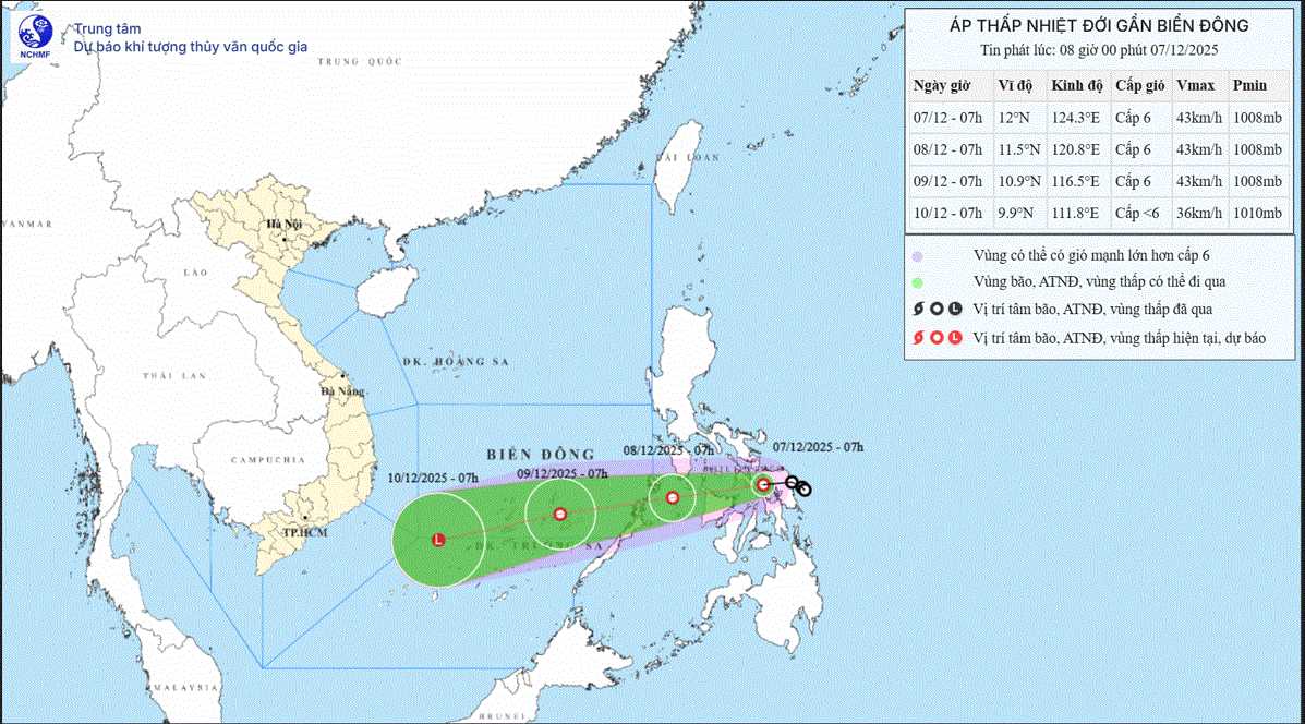
At 7:00 a.m. on December 9, the center of the low pressure was at 10.9 degrees north latitude, 116.5 degrees east longitude; in the northeastern area of Truong Sa province, about 240km east-southeast of Song Tu Tay island, strong intensity level 6, gust level 8, moving west-southwest, about 20km/h.
Warning in the next 48-72 hours, the low pressure will continue to move in the west-southwest direction, 20-25 km/h, gradually weakening.
From the morning of December 8, the sea area southeast of the central East Sea (including the sea area northeast of Truong Sa area) will have winds gradually increasing to level 6, gusting to level 8, waves 2-4m high, rough seas.
Ship in the danger zone may encounter thunderstorms, whirlwinds, strong winds, and large waves.


