Forecast of the possibility of storm No. 13 suddenly intensifying before making landfall

Khánh Minh |

It is not ruled out that Typhoon Kalmaegi - the predecessor of Typhoon No. 13 - will suddenly accelerate before making landfall, when the storm is at or near its peak intensity.

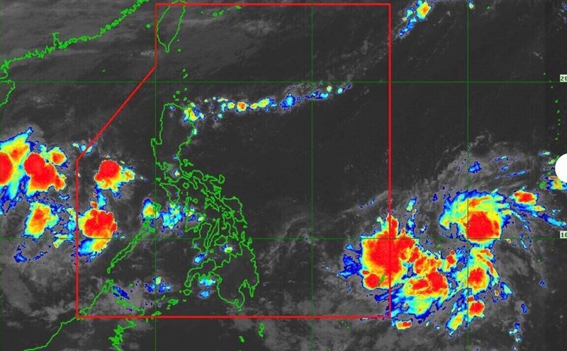
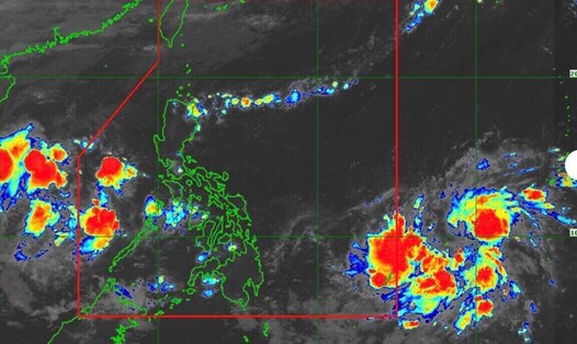
According to the latest storm information from the Philippine Atmospheric, Geophysical and Astronomical Services Administration (PAGASA), at 5:30 a.m. this morning, tropical storm Kalmaegi officially entered the Philippine Forecast Area (PAR) and was domestically named Tino.

The center of the storm is located at 10.7 degrees north latitude; 136.1 degrees east longitude, 1,230km east of Eastern Visayas. Maximum winds near the center of the storm are 85 km/h, gusting to 105 km/h.

In the next 24 hours, the storm is expected to move west-northwest at 15 km/h, then change direction to west, heading straight to the Visayas or Caraga area - which is expected to be the first landfall of the storm on the evening of November 3 or the morning of November 4.

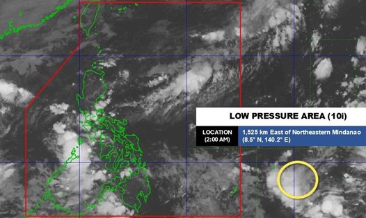
After sweeping across the central Philippines, the storm is likely to cross the Sulu Sea and Palawan, then enter the East Sea on November 5, continuing to maintain its strong intensity.

PAGASA warned that Kalmaegi could strengthen into a typhoon in the next 24 hours, reaching 140 km/h (level 13.) as it approaches land. The possibility of a sudden acceleration before making landfall cannot be ruled out, while the storm is at or near its peak intensity, PAGASA stressed.

During the storm's crossing over the Philippines, Kalmaegi is forecast to maintain a strong typhoon level, before reaching the East Sea with the possibility of continuing to operate as a strong tropical storm or a near-term super typhoon.

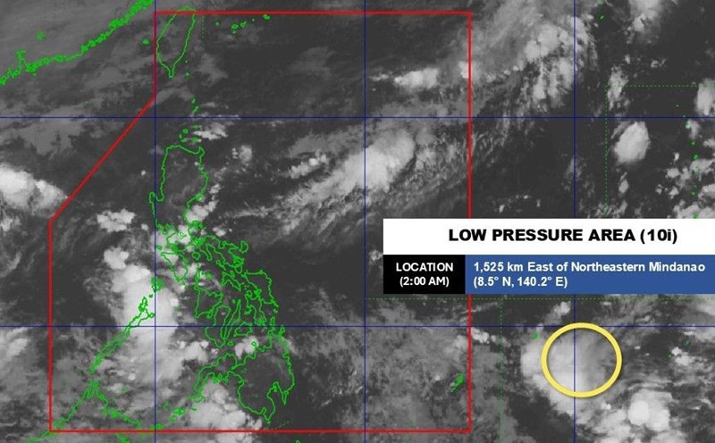
Regarding rain forecasts, from the morning of November 3, heavy to very heavy rain will cover Eastern Visayas and Caraga, then expand to Central Visayas, Palawan and part of Mindanao.

Due to the combined influence of storm Kalmaegi and the northeast monsoon, the northern, western and eastern seas of Luzon, as well as eastern Visayas and Mindanao, will have high waves and rough seas in the next 3 days.

The governments of Capiz, Surigao del Norte provinces and many localities in the Visayas have decided to temporarily suspend study, work and all maritime activities from November 3 to avoid damage.

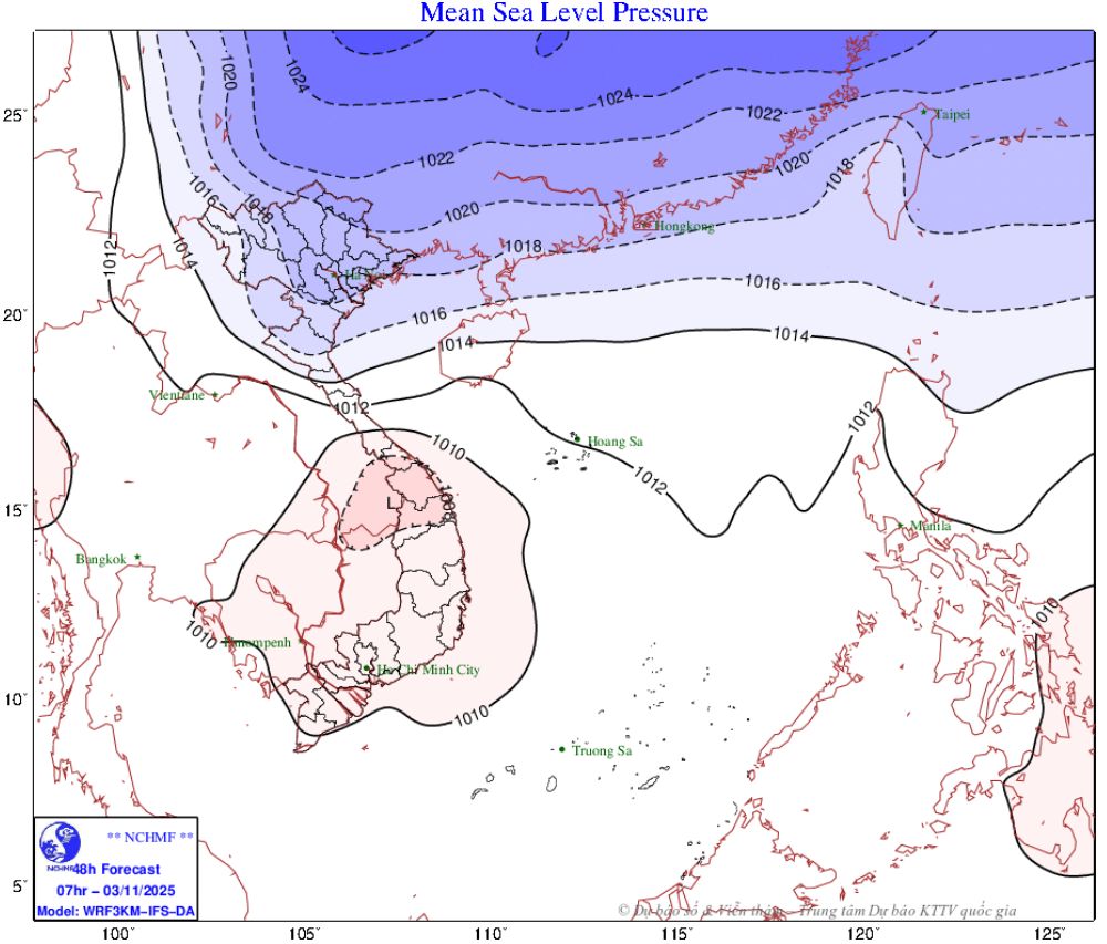
According to Kalmaegi's forecast track, after crossing the Philippines, the storm will enter the South China Sea on November 5, becoming the 13th storm, and is likely to reach the central coast between November 6-7.

The landfall location and storm intensity at this time are uncertain, but it is very likely to enter the Central Central region, focusing on the area from Da Nang to Quang Ngai. The storm's circulation can cause heavy to very heavy rain in the provinces from Ha Tinh to Khanh Hoa.

In the North, on November 2, cold air continuously strengthened, expanding the area affecting the Northwest, North Central and some places in the Central Central region.

Du bao khong khi lanh. Anh: Trung tam Du bao Khi tuong Thuy van Quoc gia Viet Nam
Cold air forecast. Photo: Vietnam National Center for Hydro-Meteorological Forecasting

Weather forecast for the night of November 2 and 3: Northeast and Thanh Hoa have the lowest temperature of 17-20 degrees Celsius, mountainous areas below 16 degrees Celsius; Northwest and Nghe An 18-21 degrees Celsius.

Night 3 and November 4: The Northeast and Thanh Hoa have the lowest temperature of 16-19 degrees Celsius, mountainous areas below 15 degrees Celsius. The Northwest and Nghe An have the lowest temperature of 15-17 degrees Celsius.

About Hanoi weather: On November 2, the lowest temperature was 18-20 degrees Celsius. The highest temperature was 21-23 degrees Celsius. The weather was cloudy, with scattered rain. Northeast wind level 2-3. Cold weather; cold at night.

Khánh Minh
RELATED NEWS

New forecast on the possibility of storm Tino strengthening into a super typhoon near the East Sea

|

Hurricane Tino is forecast to bring heavy rain to the Philippines and is unlikely to become a super typhoon near the South China Sea.

Forecast of when storm Tino near the Philippines will enter the East Sea

|

The new low pressure has appeared in the East Sea while the low pressure near the Philippines has strengthened into a tropical depression, forecast to soon become storm Tino and enter the East Sea.

Forecast of the risk of 2-3 typhoons near the East Sea in November

|

The low pressure is forecast to strengthen into a storm in early November, and there may be 2-3 storms near the East Sea throughout the month.

Storm No. 13 Melissa forecasts 3 unpredictable moving scenarios

|

A new tropical storm or hurricane is expected to form in the Atlantic this week. This is the 13th storm this year in this area.

Commune government in Gia Lai speaks out about the case of large trees rising unusually in the middle of the Ayun River bank

|

Gia Lai - Phu Thien commune authorities determined that the large piece of wood that had risen on the banks of the Ayun River had been submerged in water for a long time, with no signs of being newly sawed and the owner unknown.

Cold air intensifies and causes rain, forecast coldest day

|

Due to the strengthening of cold air, the temperature continued to decrease on the night of November 3 and November 4. The mountainous areas of the North will have severe cold, with temperatures dropping below 15 degrees Celsius.

Banning all cars across the Lo River bridge in Phu Tho

|

Phu Tho - The provincial Department of Construction has just announced the adjustment of traffic flow through the Lo River Bridge, Doan Hung Commune.

Quoc Cuong Gia Lai has spent an additional VND900 billion to get back the Bac Phuoc Kien project

|

HCMC - Quoc Cuong Gia Lai's biggest financial burden is still the obligation related to the Bac Phuoc Kien residential area project.

New forecast on the possibility of storm Tino strengthening into a super typhoon near the East Sea

Thanh Hà |

Hurricane Tino is forecast to bring heavy rain to the Philippines and is unlikely to become a super typhoon near the South China Sea.

Forecast of when storm Tino near the Philippines will enter the East Sea

Thanh Hà |

The new low pressure has appeared in the East Sea while the low pressure near the Philippines has strengthened into a tropical depression, forecast to soon become storm Tino and enter the East Sea.

Forecast of the risk of 2-3 typhoons near the East Sea in November

Khánh Minh |

The low pressure is forecast to strengthen into a storm in early November, and there may be 2-3 storms near the East Sea throughout the month.

Storm No. 13 Melissa forecasts 3 unpredictable moving scenarios

Thanh Hà |

A new tropical storm or hurricane is expected to form in the Atlantic this week. This is the 13th storm this year in this area.