On February 25, the US National Weather Service (NWS) released a forecast of notable storms/low pressure, global weather.
MJO is obstructed, progress interrupted
After many months of maintaining strong signals, the Madden-Julian (MJO) fluctuations have encountered intervention from equatorial Rossby waves and La Nina ground conditions, slowing down its movement to the east.
The MJO quickly moved across the Western Pacific Ocean but was then stalled as it moved into the Western Hemisphere.
This interruption causes convection along the equator, affecting the dry mark of La Nina in the central Pacific near the Daylight District.
However, in the past few days, MJO's signal has gradually recovered. It is forecasted that next week, MJO will regain strength and move into the Indian Ocean.
Tropical storm explodes in the Southern Hemisphere
Last week began with a quiet period, with no new storms forming. The prolonged typhoon Taliah also officially lost its tropical characteristics on February 19 before being absorbed into the west wind.
However, since February 20, the Southern Hemisphere has entered the tropical storm explosion phase with 5 new systems forming:
Storm Alfred (22.2): Appears in the North East Sea after being monitored by the Joint Typhoon Warning Center (JTWC) since February 20. The storm is moving east and then changing direction to the south, currently heading towards the east coast of Australia.
Storm Rae (22.2): Forming in the South Pacific near the Changing Road, quickly strengthening to 166 km/h but is currently weakening.
Storm Bianca (23.2): monitored by the JTWC since February 20, formed in the Timor Sea. After moving around the southern subtropical edge of Western Australia, the storm is continuing its southward trend.
Storm Seru (24.2): Appearing in northern New Caledonia, currently moving southeast towards the New Year's Eve.
Typhoon Garance (25.2): Forming off the northeast coast of Japan, it is forecast to approach a deep subtropical edge east of and change direction strongly to the south, towards the Union Island.
The possibility of another storm forming east of Madagascar is also being monitored in the next 24 hours.
Forecast of storms in the coming time
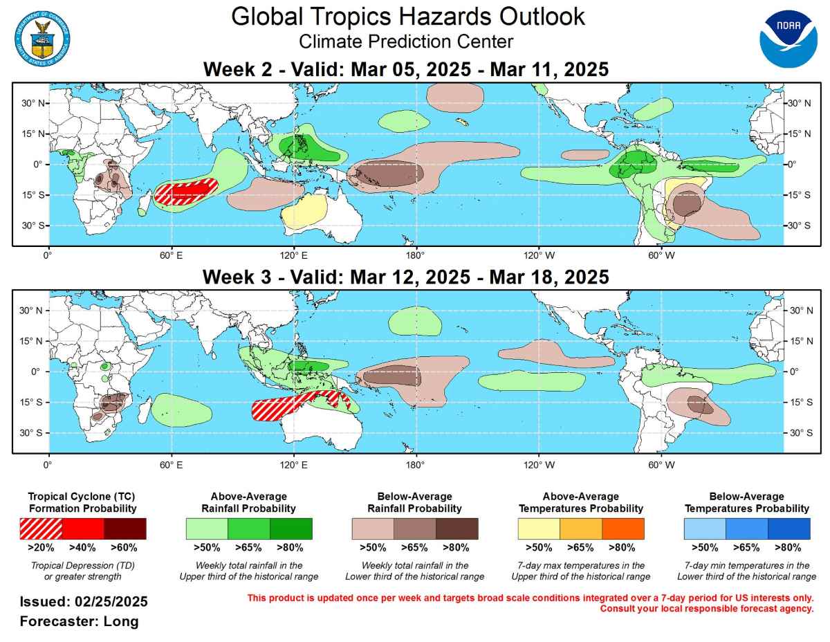
As MJO is still in the process of reorganizing for the next two weeks, the storm forecast is somewhat uncertain.
However, the western Indian Ocean is expected to have strong convection, increasing the likelihood of storm development.
ECMWF and GEFS models both support this possibility, so the rate of storm formation is given at 40-60% in the central Indian Ocean (about 60 degrees east) and 20-40% from northern Madagascar to about 80 degrees east.
In the South Pacific, some models also suggest the possibility of developing tropical cyclones near the Day-to-day Road. However, this signal is likely to be a linkage of existing systems, while this area is expected to have a subsidence of convection.
In the third week, as MJO re-establishes its single-way and strong convective zone model towards Australia, the likelihood of typhoon formation will increase slightly in the area from the West Indian Ocean to Carpentaria Bay.
Coming climate change will be greatly affected by MJO's reorganization and the prolonged impact of La Nina, with many areas needing to be on guard for upcoming tropical storms.