New low pressure forms, forecasting the possibility of strengthening into a storm

Chí Long |

A new low pressure has formed in the Pacific Ocean.

According to storm news, the latest low pressure from the Joint Typhoon Warning Center (JTWC), a new low pressure has formed in the Pacific Ocean.

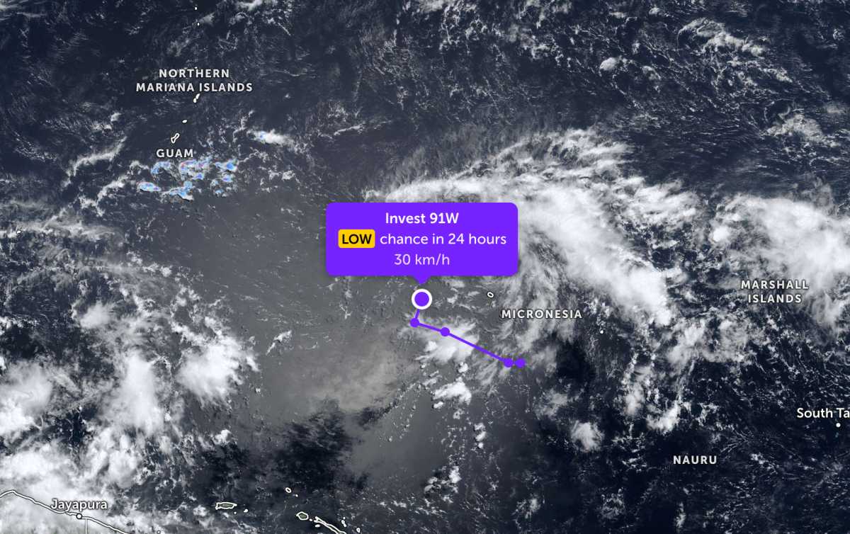
As of the morning of April 29, the low pressure bearing the symbol Invest 91W is located in the western Pacific region. The strongest wind near the center of the low pressure reaches 30 km/h.

JTWC forecasts that the low pressure is unlikely to strengthen into a storm in the next 24 hours.

Because it is still quite far from the mainland, the low pressure has not caused much impact on the mainland areas around the area.

Áp thấp mới hình thành trên biển Thái BìnH Dương. Ảnh: JTWC
New low pressure formed in the Pacific Ocean. Photo: JTWC

In the East Sea, according to the National Center for Hydro-Meteorological Forecasting, on the morning of April 29, the cold air mass in the North is continuing to move south, causing scattered showers in the Northern Gulf area, with thunderstorms in some places.

Forecast for the day and night of April 29, the Gulf of Tonkin area will have scattered showers and thunderstorms. The area north of the Gulf of Tonkin and the sea area north of the Northern East Sea area will have strong Northeast wind at level 5, sometimes level 6, gusting at level 7. Sea is rough, waves are 1.5–2.5m high.

In thunderstorms, there is a possibility of tornadoes and strong gusts of wind. People and tourists planning to visit these sea areas should pay attention to weather forecasts. Check flight schedules and follow local instructions to avoid storms and big waves at sea that are dangerous.

Chí Long
TIN LIÊN QUAN

New low pressure forms

|

A new low pressure has just formed over the Indian Ocean. Super typhoon Sinlaku is hovering over the Western Pacific after making landfall on the North Mariana Islands of the United States.

Cold air compresses low pressure trough, forecast for heavy rain in the area soon

|

Weather forecast in the North has a weak cold air mass moving southward, compressing a low pressure trough with its axis at about 24-27 degrees North latitude.

Tropical depression near the East Sea has the potential to become a super typhoon

|

It is forecast that a tropical depression will strengthen into a storm, entering the Philippine monitoring area next week. The storm will be named locally "Caloy".

New low pressure forms

Chí Long |

A new low pressure has just formed over the Indian Ocean. Super typhoon Sinlaku is hovering over the Western Pacific after making landfall on the North Mariana Islands of the United States.

Cold air compresses low pressure trough, forecast for heavy rain in the area soon

Chí Long |

Weather forecast in the North has a weak cold air mass moving southward, compressing a low pressure trough with its axis at about 24-27 degrees North latitude.

Tropical depression near the East Sea has the potential to become a super typhoon

Dương Đông |

It is forecast that a tropical depression will strengthen into a storm, entering the Philippine monitoring area next week. The storm will be named locally "Caloy".