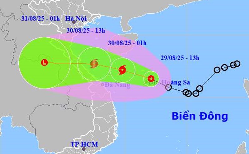
According to the latest storm information from the National Center for Hydro-Meteorological Forecasting, at 4:00 a.m. on August 30, the center of the tropical depression was at 17.7 degrees North latitude - 109.2 degrees East longitude, in the northwest sea of Hoang Sa special zone, about 290km East Southeast of North Quang Tri.
The strongest wind near the center of the low pressure is level 7 (5061km/h), gusting to level 9. The tropical depression is moving northwest at a speed of 20km/h.
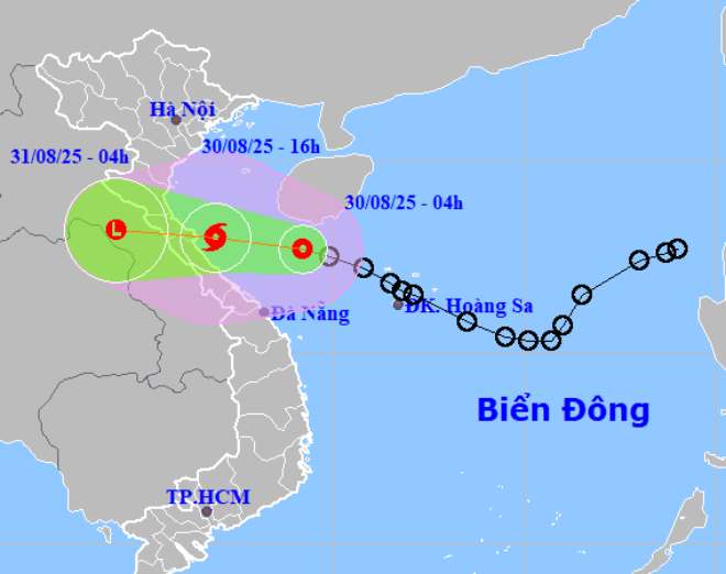
It is forecasted that by 4:00 p.m. this afternoon, the tropical depression will move in a West-Northwest direction at a speed of about 20km/h and is likely to strengthen into a storm. The center of the storm is located at about 18.0 degrees North latitude - 106.9 degrees East longitude, right in the sea from Quang Tri to Hue.
The strongest wind near the storm center is level 8, gusting to level 10. Natural disaster risk level: level 3 for the western sea area of the North East Sea (including Hoang Sa special zone), the sea area from Nghe An to Da Nang province (including Hon Ngu island, Con Co special zone).
At 4:00 a.m. on August 31, the storm moved westward at a speed of about 20km/h and made landfall. At that time, storm No. 6 will gradually weaken into a tropical depression, then weaken into a low pressure area. The center of the low pressure is located at about 18.2 degrees North latitude - 104.3 degrees East longitude, in the Central Laos area.
The strongest wind in the center of the low pressure is less than level 6. Natural disaster risk level: level 3 for the sea area from Thanh Hoa to Hue (including Hon Ngu island, Con Co special area).
Due to the influence of the tropical depression, the northwest area of the East Sea (including Hoang Sa): strong winds of level 67. Waves are 2.04.5m high, rough seas.
The sea area from Thanh Hoa to Hue (including Hon Ngu, Con Co) will have strong thunderstorms, winds gradually increasing to level 67, near the storm center level 8, gusting to level 10. Waves 2.04.0m high, near the center of the storm 3.05.0m high; rough seas. Coastal areas from Nghe An to Hue have water levels rising 0.20.4m.
The weather at sea and in coastal mainland areas is very dangerous and unsafe for vehicles and works operating in dangerous areas such as: Tourist boats, passenger ships, transport ships, cages, rafts, aquaculture areas.
From noon on August 30, the coastal area of Nghe An - Quang Tri will have winds gradually increasing to level 6, gusting to level 8. In particular, the mainland along the coast of Ha Tinh - Bac Quang Tri has strong winds of level 67, near the storm center level 8, gusting to level 10. Strong thunderstorms and tornadoes may appear before the tropical depression/storm directly affects.
From the morning of August 30 to the end of August 31, the area from Thanh Hoa to Hue will have heavy to very heavy rain. The common rainfall was 150300mm, locally more than 500mm.
From August 30 to the end of August 31, the midlands, Northern Delta and Da Nang city will have moderate rain, heavy rain, locally very heavy rain. Rainfall is generally from 70150mm, in some places more than 300mm.
The Hanoi area is cloudy, sometimes with showers and thunderstorms, in the afternoon and at night there is moderate rain, heavy rain and scattered thunderstorms, locally very heavy rain.
People and tourists going out should pay attention to bring umbrellas and raincoats, to prevent sudden changes in weather. Tuan follows local instructions to avoid storms that cause impacts.