According to the latest weather forecast from the Philippine Atmospheric, Geophysical and Astronomical Services Administration (PAGASA), as of 8:00 a.m. on September 3 (local time), the low pressure near the East Sea in the Philippine Area of Responsibility has strengthened into a tropical depression. The tropical depression has the local name Kiko.
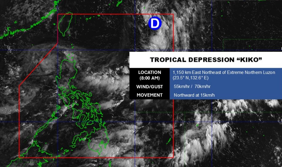
The center of the tropical depression is located at about 23.5 degrees North latitude - 132.6 degrees East longitude, about 1,150 km northeast of the northernmost tip of Luzon.
The tropical depression is moving north at a speed of about 15 km/h. The strongest wind near the center of the tropical depression reached 55 km/h, gusting up to 70 km/h.
Due to the distance, the tropical depression has not yet affected the mainland of the Philippines.
In the East Sea, according to the National Center for Hydro-Meteorological Forecasting, in the early morning of September 3, a tropical convergence zone with an axis at about 13-16 degrees North latitude connected with a low pressure area in the Central East Sea, at 1:00 a.m. at about 14.5-15.5 degrees North latitude - 111.5-112.5 degrees East longitude.
The sea area from Khanh Hoa to Ca Mau, Ca Mau to An Giang, the Gulf of Thailand, the eastern sea area of the North East Sea, the Central and South East Sea (including the Truong Sa special zone) will have scattered showers and thunderstorms.
It is forecasted that during the day and night of September 3, the sea areas from Quang Ngai to Ca Mau, the sea areas from Ca Mau to An Giang, the Gulf of Thailand, the eastern sea area of the North East Sea, the Central and South East Sea (including the Truong Sa special zone) will have showers and thunderstorms.
In addition, the offshore waters from Khanh Hoa to Lam Dong and the South East Sea area (including Truong Sa special zone) will have strong southwest winds of level 5, sometimes level 6, gusting to level 7-8. Waves are 1.5-3.0m high, rough seas.
During thunderstorms, there is a possibility of tornadoes and strong gusts of wind of level 6-7. Waves are over 2.0m high.
People and tourists planning to visit these coastal areas should pay attention to weather forecasts. Tuan followed local instructions to avoid dangerous storms and floods throughout the journey.


