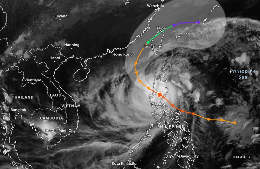
According to the National Center for Hydro-Meteorological Forecasting, today, November 10, super typhoon Fung-wong passed through the mainland of the Philippines and officially entered the East Sea. This is the 14th storm to hit the East Sea this year.
As of 7:00 p.m. tonight, the center of the storm was at about 17.6 degrees North latitude - 118.1 degrees East longitude, in the eastern sea of the North East Sea. The strongest wind near the storm center is level 13, gusting to level 16. The super typhoon has weakened into a typhoon. Typhoon Fung-wong will move west-northwest for about 20km.
Next, the storm will move north and northeast towards Taiwan (China). Typhoon Fung-wong is not forecast to threaten the mainland of Vietnam.
However, due to the impact of the storm, the eastern sea area of the North East Sea will have strong winds of level 6-7, then increase to level 8-10; the area near the storm's center will have strong winds of level 11-13, gusting to level 16. Waves are 4.0-6.0m high, then increasing to 6.08,0m, near the center of the storm 8.0-10.0m. The sea is rough.
All boats operating in the above dangerous areas are likely to be affected by thunderstorms, whirlwinds, strong winds, and large waves.
People and tourists planning to travel to the Philippines, Taiwan (China) or areas where the storm passes should pay attention to weather forecasts. Check flight schedules and consider adjusting routes to ensure safety.
Weather forecast for today, November 10, nationwide:
City. Hanoi
Lowest temperature: 21-23 degrees Celsius Highest temperature: 26-28 degrees Celsius Cloudy, scattered showers and thunderstorms.
Northeast to east wind level 2-3.
Northwest
Lowest temperature: 19-22 degrees Celsius, some places below 19 degrees Celsius Highest temperature: 24-27 degrees Celsius, some places above 27 degrees Celsius Cloudy, scattered rain, showers and thunderstorms.
Light wind.
Northeast
Lowest temperature: 21-24 degrees Celsius, mountainous areas below 20 degrees Celsius Highest temperature: 25-28 degrees Celsius Cloudy, scattered showers and thunderstorms.
Northeast to east wind level 2-3.
Thanh Hoa to Hue
Lowest temperature: 22-25 degrees Celsius Highest temperature: North 26-29 degrees Celsius, South 30-32 degrees Celsius North cloudy, rain, scattered showers and thunderstorms; South cloudy, scattered showers and thunderstorms.
North to northwest wind level 2-3.During thunderstorms, there is a possibility of tornadoes, lightning and strong gusts of wind.
South Central Coast
Lowest temperature: 23-26 degrees Celsius, some places below 23 degrees Celsius Highest temperature: 30-33 degrees Celsius Cloudy, scattered showers and thunderstorms at night; sunny during the day.
Light wind.During thunderstorms, there is a possibility of tornadoes, lightning and strong gusts of wind.
Central Highlands
Lowest temperature: 19-22 degrees Celsius Highest temperature: 27-30 degrees Celsius, some places above 30 degrees Celsius Cloudy, showers and thunderstorms in the evening and at night; sunny during the day.
Light wind.During thunderstorms, there is a possibility of tornadoes, lightning and strong gusts of wind.
Southern region
Lowest temperature: 23-26 degrees Celsius Highest temperature: 30-33 degrees Celsius Cloudy, showers and thunderstorms in the evening and at night; sunny during the day.
Light wind.During thunderstorms, there is a possibility of tornadoes, lightning and strong gusts of wind.
Ho Chi Minh City
Lowest temperature: 24-26 degrees Celsius Highest temperature: 31-33 degrees Celsius Cloudy, showers and thunderstorms in the evening and at night; sunny during the day.
Light wind.During thunderstorms, there is a possibility of tornadoes, lightning and strong gusts of wind.


