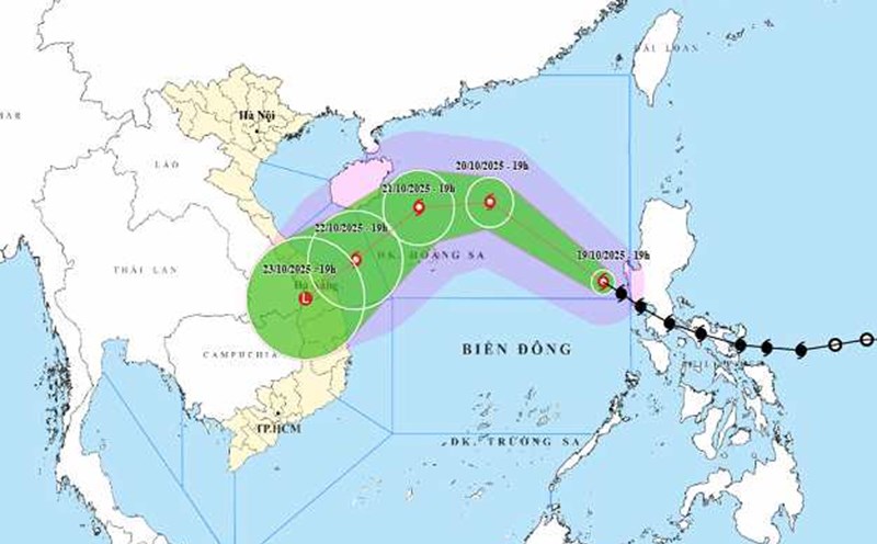
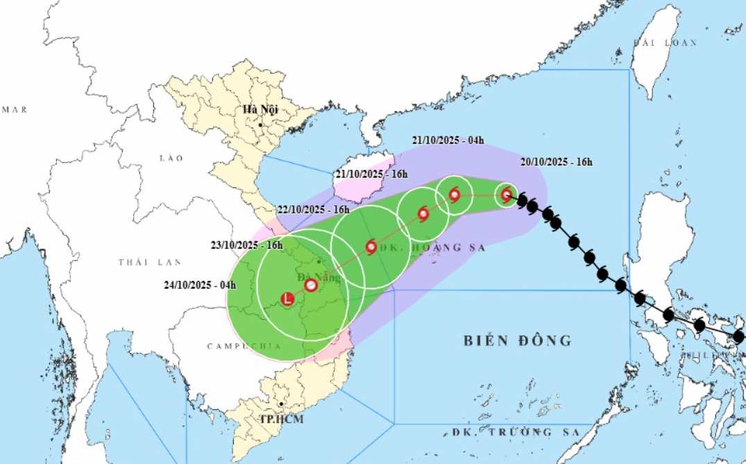
According to the latest storm news from the National Center for Hydro-Meteorological Forecasting, on October 20, the center of storm No. 12 Fengshen was about 380km east-northeast of Hoang Sa Special Zone. The strongest wind near the storm center is level 9-10 (75-102km/h), gusting to level 12. The storm is moving in a West-Northwest direction, at a speed of about 20km/h.
It is forecasted that by 4:00 p.m. on October 21, the storm will change direction to the West, then to the West Northwest at a speed of about 10-15 km/h. The center of the storm is located at about 17.8 degrees North latitude - 112.1 degrees East longitude, in the sea north of the Hoang Sa special zone.
Storm No. 12 is forecast to strengthen as it heads towards the central coast of our country. The strongest wind near the storm center is level 11, gusting to level 13. Disaster risk level: Level 3 for the North East Sea area (including Hoang Sa special zone).
Storm No. 12 is forecast to make landfall in the Da Nang - Quang Ngai area on October 23. The storm had weakened into a low pressure area by then.
Due to the influence of storm No. 12, the North East Sea area (including Hoang Sa special zone) has strong winds of level 7-8; the area near the storm's eye has strong winds of level 9-11, gusting to level 13. Waves 3.0-5.0m high, near the center of the storm 5.0-7.0m high, rough seas. All ships and boats in the danger zone are at risk of being affected by thunderstorms, whirlwinds, strong winds and large waves.
On land, due to the influence of storm circulation and cold air combined with East wind disturbances, terrain effects and East winds after the storm, from the night of October 22 to October 26, the area from Ha Tinh to Quang Ngai is likely to have widespread heavy rain.
Total rainfall is generally in: Ha Tinh to Bac Quang Tri and Quang Ngai about 200-400 mm, locally over 500 mm; the South Quang Tri to Da Nang area is generally 500-700 mm, locally over 900 mm. Heavy rain in the Central region is likely to last until the end of October 2025.
There is a high risk of flash floods and landslides in mountainous areas, flooding in low-lying areas and urban areas. Localities need to pay attention to safe operation of hydroelectric and irrigation reservoirs before, during and after the storm, and prepare response plans for flood scenarios on rivers from Quang Tri to Quang Ngai that are likely to reach alert level 3 and exceed alert level 3. Forecast of natural disaster risk level due to floods: level 3.
Weather forecast for tonight and tomorrow, October 21 nationwide:
City. Hanoi
Lowest temperature: 21-23 degrees Celsius.
Highest temperature: 29-31 degrees Celsius.
Cloudy, no rain at night; sunny during the day.Northeast wind level 3.
Northwest
Lowest temperature: 19-22 degrees Celsius, some places in the highlands below 16 degrees Celsius.
Highest temperature: 28-31 degrees Celsius.
Cloudy, scattered showers at night; sunny during the day.Light wind.Cold at night and morning, some places are cold.
Northeast
Lowest temperature: 20-23 degrees Celsius, some places in high mountains below 16 degrees Celsius.
Highest temperature: 28-31 degrees Celsius.
Cloudy, no rain at night; sunny during the day.Northeast wind level 3, especially in coastal areas level 3-4.Cold at night and morning, some mountainous areas are cold.
Thanh Hoa to Thua Thien Hue
Lowest temperature: 22-25 degrees Celsius.
Highest temperature: 28-31 degrees Celsius.
Cloudy, scattered showers and thunderstorms; in the South, there will be rain, scattered showers and thunderstorms, locally heavy rain.North to northwest wind level 3, coastal areas level 3-4.During thunderstorms, there is a possibility of tornadoes, lightning and strong gusts of wind.
South Central Coast
Lowest temperature: 23-26 degrees Celsius.
Highest temperature: 29-32 degrees Celsius.
Cloudy, the North has rain, showers and scattered thunderstorms, locally heavy rain; the South has scattered showers and thunderstorms, in the afternoon and evening there are scattered showers and thunderstorms, locally heavy rain.Northeast wind level 2-3.During thunderstorms, there is a possibility of tornadoes, lightning and strong gusts of wind.
Central Highlands
Lowest temperature: 19-22 degrees Celsius.
Highest temperature: 27-30 degrees Celsius, some places above 30 degrees Celsius.
Cloudy, scattered showers and thunderstorms in some places; in the afternoon and evening, there will be scattered showers and thunderstorms, locally heavy rain in some places.Light wind.During thunderstorms, there is a possibility of tornadoes, lightning, hail and strong gusts of wind.
Southern region
Lowest temperature: 23-26 degrees Celsius.
Highest temperature: 31-34 degrees Celsius.
Cloudy, scattered showers and thunderstorms in some places; in the afternoon and evening, there will be scattered showers and thunderstorms, locally heavy rain in some places.Light wind.During thunderstorms, there is a possibility of tornadoes, lightning, hail and strong gusts of wind.
Ho Chi Minh City
Lowest temperature: 24-26 degrees Celsius.
Highest temperature: 32-34 degrees Celsius.
Cloudy, scattered showers and thunderstorms in some places; in the afternoon and evening, there will be scattered showers and thunderstorms, locally heavy rain in some places.Light wind.During thunderstorms, there is a possibility of tornadoes, lightning, hail and strong gusts of wind.