
According to storm and low pressure news from the Philippine Atmospheric, Geophysical and Astronomical Services Administration (PAGASA), Super Typhoon Ba Vi is approaching the Philippine Area of Responsibility (PAR).
By 3 pm this afternoon, the center of super typhoon Ba Vi was located at about 15.0 degrees North latitude - 143.8 degrees East longitude, about 2,120 km east of the Southeast Luzon Island area.
Meanwhile, the Joint Typhoon Warning Center (JTWC) forecasts that Super Typhoon Ba Vi is about 165 km northwest of Andersen Air Force Base.
In the past 6 hours, the storm has moved in a West-Northwest direction at a speed of about 20 km/h. The strongest wind near the super typhoon center reached 270 km/h. The highest wave recorded is about 15.8 m.
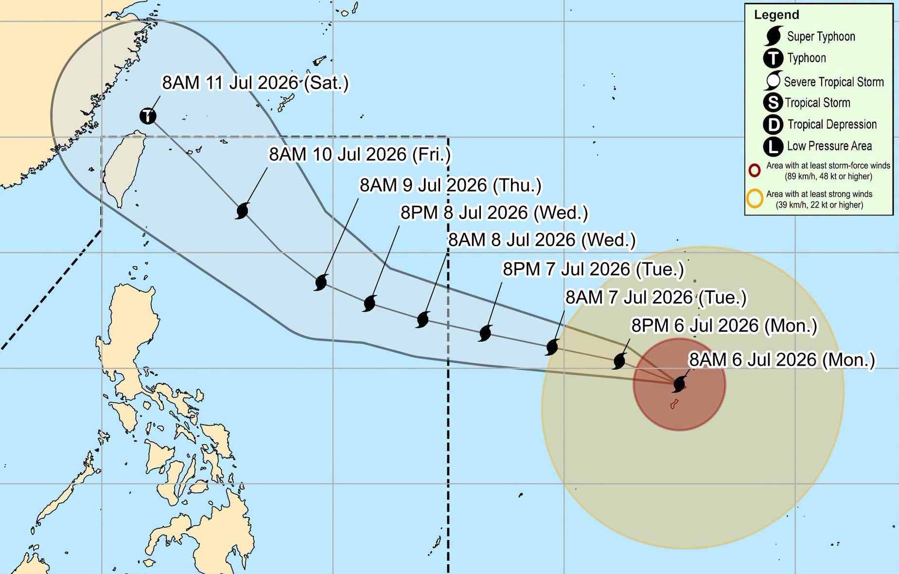
According to PAGASA, the circulation of Super Typhoon Ba Vi has not yet directly affected the mainland of the Philippines. However, the East wind is still affecting the Northeast Luzon and Central Luzon areas, causing Cagayan Valley and Aurora province to have clouds, showers and scattered thunderstorms.
The capital Manila and the rest of the Philippines are forecast to have variable cloudiness, local showers and thunderstorms due to local convection, also posing a risk of localized flooding and landslides in places with heavy rain.
Super typhoon Ba Vi is forecast to continue moving in a West-Northwest direction and will enter the Philippine Area of Responsibility (PAR) from the evening of July 7 to the early morning of July 8. When entering PAR, the typhoon will be named Inday before heading towards the Ryukyu Islands.
PAGASA assesses that Super Typhoon Ba Vi is likely to maintain its super typhoon intensity when entering PAR and will only gradually weaken as it approaches the northernmost point of Luzon Island, heading towards the east of Taiwan Island (China).
Although the possibility of landfall in Luzon is not high, the storm's circulation may cause strong winds and heavy rain due to the strengthening Southwest monsoon and rough seas in the northern and eastern Philippines from July 8.
According to the assessment of the National Center for Hydro-Meteorological Forecasting, the possibility of super typhoon Ba Vi entering the East Sea is currently not high, with a probability of less than 10%. However, due to its very strong intensity, the typhoon's circulation may still affect the northeastern sea area of the Northern East Sea in the period from July 9 to 11.
At the same time, the wind-absorbing impact of the storm will make the Southwest wind in the central and southern areas of the East Sea, including the Hoang Sa and Truong Sa special zones, gradually strengthen from July 9. On July 9-11, the wind may reach level 6-7, sea waves 3-5 m high, causing very strong sea turbulence.
People and tourists planning to visit areas affected by super typhoons should pay close attention to weather developments. Check flight schedules regularly and follow local instructions to avoid dangerous storms.


