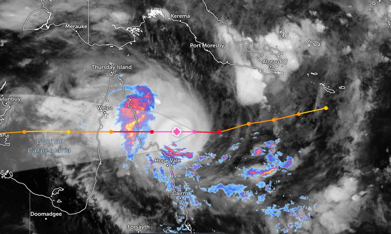
According to the Australian Bureau of Meteorology (BOM), on the afternoon of March 19, Super Typhoon Narelle strengthened to Category 5 - the highest level in the scale, when moving over the warm waters of the Coral Sea. It is expected that the storm will make landfall in the northernmost area of Queensland at around 7 am on March 20 (local time), about 3 hours earlier than previously forecast.
In just 48 hours, super typhoon Narelle rapidly intensified and reached maximum intensity offshore. In the afternoon of March 19, the storm's eye was about 374 km north-northeast of Cairns. In the past 6 hours, the storm has moved westward at a speed of about 20km/h.
Meteorological experts believe that unusually warm seawater conditions along with favorable wind circulation have caused the storm to strengthen rapidly, reaching near-major before making landfall.
This is assessed as the first Category 5 storm to make landfall in the Cape York area since the Mahina storm disaster in 1899 that killed more than 300 people. If the current scenario occurs, Narelle will also be one of the very few Category 5 storms to make landfall on the coast of Queensland in the past 50 years.
Faced with the risk of serious damage, the state government has implemented a series of emergency measures. According to Chief Minister David Crisafulli, vulnerable communities have been evacuated, tourists have left on the last flights, while many areas have prepared for a widespread power outage scenario.
About 8 schools with nearly 780 students have been closed since March 19, and many other schools may continue to shut down as the storm makes landfall. More than 100 emergency service staff have been dispatched to the north, with police going to each house to check people's preparations.
Resupply containers and backup generators have also been deployed to ensure response when natural disasters occur.
Australian authorities have repeatedly issued strong warnings about the danger of the storm. Prime Minister Crisafulli emphasized: "This is a serious storm. I cannot evade - the damage will be widespread.
He also warned people to pay special attention to strong winds, heavy rain, high tides and the risk of flash floods when storms make landfall.
According to BOM experts, Typhoon Narelle may bring rainfall from 150mm to 300mm/day in the Cape York area, even up to 450mm in some places.
This large amount of rain is enough to cause flash floods and cause river water levels to rise rapidly, increasing the risk of widespread flooding.
Functional agencies call on people to closely monitor weather developments, comply with evacuation instructions and prepare sufficient necessities to ensure safety before the storm makes landfall.
Tourists planning to visit Cape York and its vicinity during this time should pay attention to weather forecasts. Consider your itinerary and check your flight schedule regularly to avoid dangerous storms.


