According to the latest low pressure news from the Philippine Atmospheric, Geophysical and Astronomical Services Agency (PAGASA), on the afternoon of January 5, a new low pressure area was formed in the southern South China Sea area.
As of 2 pm today (local time), the center of the low pressure is located at about 6.1 degrees North latitude - 111.5 degrees East longitude, about 630 km south of the southernmost point of Pagasa Island. The low pressure is forecast to have little chance of developing into a tropical depression in the next 24 hours.
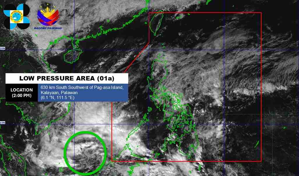
This is the first low pressure area to form in the East Sea region in 2026.
Due to the influence of low pressure and low pressure troughs, according to the National Center for Hydro-Meteorological Forecasting, it is forecast that tonight, January 5, the Gulf of Tonkin area will have Northeast wind level 6, sometimes level 7, gusts level 8-9. Waves 2.5-3.5m high. Strong sea waves.
The northern East Sea area (including the Hoang Sa special zone) has northeast winds gradually strengthening to level 6-7, gusting to level 8-9. Waves 2.0-4.0m high. Sea rough.
The sea area from Khanh Hoa to Ca Mau and the sea area southwest of the East Sea (including the sea area west of the Truong Sa special zone) has Northeast wind level 6, from January 06th at times level 7, gusts level 8-9. High waves 4.0-6.0m. Strong sea waves.
Sea area from South Quang Tri to Dak Lak and the Central East Sea area: Northeast wind gradually strengthens to level 6, gusting to level 7-8. Waves 2.0-5.0m high. Sea rough.
In addition, on the night of January 5 and January 6, the Central and South East Sea areas (including the Truong Sa special zone) will have scattered showers and thunderstorms. In thunderstorms, there is a possibility of tornadoes and strong gusts of wind.
Forecast for the night of the 6th and day of January 7th, the Northern East Sea area (including Hoang Sa special zone), the sea area from Khanh Hoa to Ca Mau, the western sea area of the South East Sea (including the western sea area of Truong Sa special zone) will have strong Northeast wind at level 6, sometimes level 7, gusting level 8-9, sea waves 3.0-6.0m high, strong sea. The sea area from South Quang Tri to Dak Lak, the Central East Sea area will have strong Northeast wind at level 6, gusting level 7-8, sea waves 3.0-5.0m high, rough seas.
On the night of January 6, the Gulf of Tonkin had Northeast wind level 6, gusts level 7-8, sea waves 2.5-3.5m high. Sea rough. Level of natural disaster risk at sea: level 2.
Ships operating in the above sea areas are at high risk of being affected by strong winds and big waves. People and tourists who plan to visit these sea areas should pay attention to weather forecasts. Follow local safety instructions.


