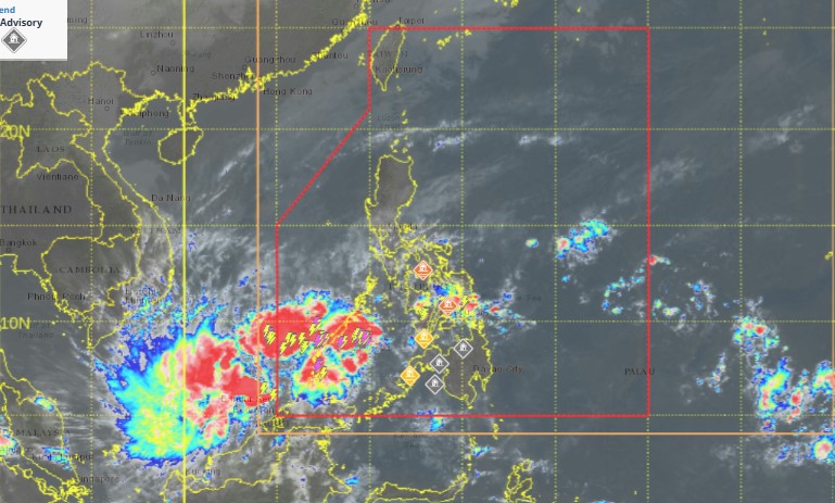
According to the latest weather forecast from the Philippine Atmospheric, Geophysical and Astronomical Services Administration (PAGASA), at 8:00 p.m. on December 20, the center of Low Pressure 12b was at about 4.3 degrees North latitude - 111.0 degrees East longitude, 1,575 km west of West Mindanao, Philippines.
As of 2:00 a.m. on December 21, the low pressure area is outside the Philippine forecast area (PAR). The possibility of this low pressure area strengthening into a tropical depression in the next 24 hours is moderate.

The Joint Typhoon Warning Center (JTWC) forecasts that the Invest 96W depression (a weakened low pressure area from Tropical Depression Querubin) is currently located in the northern Sulu Sea, creating unorganized showers and thunderstorms. However, this depression is not expected to strengthen into a tropical depression.
The JTWC said that the Invest 98W low pressure system (low pressure 12b in the southern East Sea) is becoming clearer. Although it is located near the equator, environmental conditions appear favorable for the low pressure system to develop further.
JTWC forecasts that this low pressure may strengthen into a tropical depression on December 22 or 23, when it begins to move slowly north to the north-northeast.
The low pressure is forecast to move northwest early next week, interacting and absorbing with 96W. By December 24 or 25, upper-level winds are likely to make it difficult for this low pressure to develop further.
The low pressure system is likely to bring widespread heavy rainfall to parts of Vietnam, Malaysia, Indonesia and Brunei over the next few days. The chance of the low pressure system strengthening over the next 7 days is at 50%.
The low pressure is quite far from Vietnam so it has not yet affected the mainland. However, in the next 7 days, people and tourists in areas likely to be affected by the low pressure area should pay attention to weather forecasts, announcements from airlines and transport units to proactively plan their schedules.


