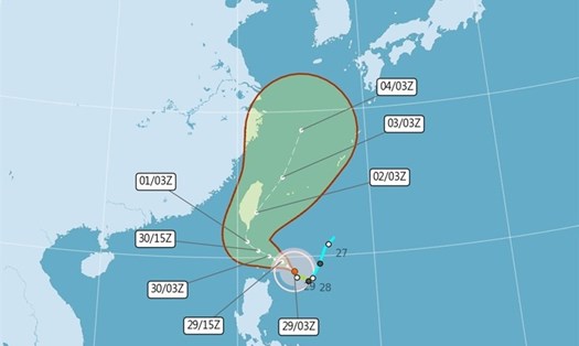
The CWA said Typhoon Krathon was moving west-northwest at 9 km/h, with maximum sustained winds of 119 km/h and gusts of up to 155 km/h.
The storm is expected to make landfall in the major port city of Kaohsiung early on October 2, then move across the southern tip of Taiwan and back out into the Pacific Ocean.
According to the Philippine Atmospheric, Geophysical and Astronomical Services Administration (PAGASA), Typhoon Krathon will be named Julian when it makes landfall in the Philippines. As of 5:00 a.m. on September 30, the storm was located at approximately 19.9 degrees north latitude - 122.2 degrees east longitude, in the waters of Balintang, Calayan, Cagayan. The strongest wind near the center of the storm increased to 155 km/h (level 14), gusting to 190 km/h (level 16), with a central pressure of 950 hPa.
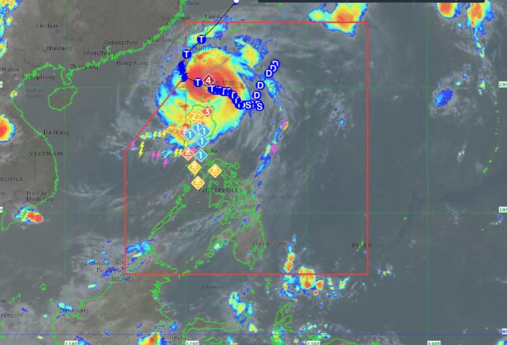
The storm is moving west at 10km per hour and continues to strengthen, with typhoon-force winds extending 560km from the center of the storm. At its current pace, the agency predicts that Krathon could become a super typhoon.
PAGASA forecasts that the storm will move west-northwest through the Balintang Channel today (September 30) and approach Balintang and Batanes islands. A direct landfall scenario in these areas is still possible.
However, the storm will be closest to Batanes and Babuyan Islands in the morning to afternoon of September 30.
The storm will begin to recurve tomorrow (October 1) while moving slowly, then turn mainly northeast on October 2, towards the southwest coast of Taiwan (China).
Typhoon Krathon may exit the Philippine Area of Responsibility (PAR) shortly. It will then cross the rugged terrain of Taiwan (China) and return to waters east of the island. It will then gradually accelerate northeastward toward the East China Sea (Pacific Ocean) and exit the PAR by October 4.
The storm will continue to strengthen and may reach super typhoon status on October 1 as it begins to recurve. As it interacts with the rugged terrain of Taiwan (China), the storm tends to weaken, but remains a typhoon until it exits the PAR region.
This is the 10th tropical storm to hit the Philippines in the 2024 typhoon season and the sixth in September alone.
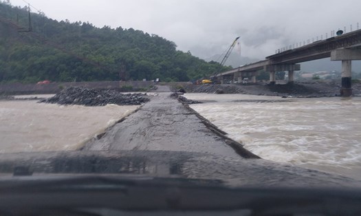
Currently, in many areas affected by the storm, there has been heavy rain and flooding... People and tourists are advised not to go out to sea or swim. Boats should be anchored at the port or find a safe place to shelter from the storm.