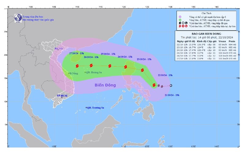
According to the National Center for Hydro-Meteorological Forecasting, at 1:00 p.m. on October 23, the center of storm Tra Mi was at about 16.2 degrees North latitude; 123.6 degrees East longitude, in the sea east of Luzon Island (Philippines). The strongest wind near the center of the storm was level 9 (75-88 km/h), gusting to level 11. Moving in the West Northwest direction, speed 15-20 km/h.
At 1:00 p.m. on October 24, the storm will move northwest and then change direction to west-southwest, 15-20 km/h, entering the East Sea. The intensity is level 9, gusting to level 11. The center of the storm is at about 16.7 degrees north latitude -119.8 degrees east longitude; in the eastern sea area of the North East Sea.
The storm is forecast to continue moving west-northwest at a speed of 10-15km/h at 1pm on October 25. The center of the storm is located at 17.2 degrees north latitude - 117.4 degrees east longitude; in the eastern sea of the North East Sea, 640km east of the Hoang Sa archipelago. The intensity is level 10, gusting to level 12.
The storm continues to move west at a speed of 15-20km/h and its center is at 17.5 degrees north latitude - 113.2 degrees east longitude; in the sea northeast of Hoang Sa archipelago at 1:00 p.m. on October 26. At this time, the intensity reaches level 12, gusting to level 15.
In the next 24 to 72 hours, the meteorological agency issued a level 3 disaster risk in the North East Sea area.
From the next 72 to 120 hours, the storm will move mainly in a westerly direction, about 15km per hour, then it will likely change direction to the South-Southwest and move more slowly.
The East Sea area of the North East Sea has strong winds of level 6-7. From early morning on October 24, it will increase to level 8 (62-74km/h), near the storm center, it will be level 9-10 (75-102km/h), gusting to level 12, waves 3-5m high, near the storm center 5-7m; very rough seas.
Ships operating in dangerous areas are likely to be affected by storms, whirlwinds, strong winds, and large waves. Ships in the Central region should come ashore to take shelter from the storm before October 26 and should not set sail in the following days due to rough seas.

Previously, on October 22, a number of flights in the Philippines were delayed or canceled due to the impact of this storm.
The cancellation of flights between major hubs like Manila and popular tourist destinations like Cebu and Laoag will certainly affect international travelers in the Philippines. Those planning vacations or business trips to these areas may face delays or cancellations, hampering future travel plans.
In Vietnam, storm Tra Mi is expected to greatly affect the weather on land around October 27-31 in the North Central region.
In the face of unpredictable weather conditions, residents and visitors in areas forecast to be affected by the storm should pay close attention to weather reports and follow the instructions of local authorities. In particular, be alert to the risk of widespread flooding and natural disasters such as flash floods and landslides in mountainous areas of the Central region due to heavy rain.


