Tropical Storm Marce (international name: Yinxing) may intensify and reach typhoon strength before making landfall in Northern Luzon, according to PAGASA.
Typhoon Marce is forecast to strengthen into a severe tropical storm on Tuesday (November 5) as it moves northwest through the Philippine Sea.
“By Tuesday evening or early Wednesday morning (November 6), this storm could reach typhoon level,” said PAGASA weather expert Veronica Torres.
Typhoon Marce is expected to make landfall near Babuyan Islands or mainland North Cagayan on Thursday evening (November 7) or early Friday morning (November 8), PAGASA experts added.
However, there is still a chance that Marce will make landfall in Cagayan or Isabela, the largest province in the Luzon region.
The typhoon was located 775 km east of Borongan City, Eastern Samar, packing maximum sustained winds of 75 km/h and gusts of up to 90 km/h as it moved west-northwest at 35 km/h.
Marce's expanding circulation has brought rain to northernmost Luzon and eastern Luzon since tomorrow morning, November 5.
PAGASA noted that the typhoon is expected to bring strong to gusty winds in Batanes, Cagayan including Babuyan Islands, Isabela, Ilocos Norte, Aurora and northern part of Quezon.
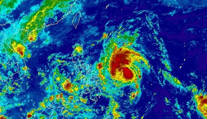
Marce is the 13th tropical storm to hit the Philippines in 2024 and the first in November.
The storm is currently affecting mainly the sea areas of Batanes, Babuyan Island, Ilocos Norte and Ilocos Sur in the Philippines, causing waves up to 3.5 meters high. Light rough seas will affect the operation of boats, especially small boats, which are advised not to go out to sea during the storm.

Typhoon season in the Philippines usually runs from August to December.
Tourists planning to visit the Philippines during this time should pay attention to weather forecasts and announcements from airlines and travel agencies to proactively change their schedules if necessary.
PAGASA estimates one or two tropical storms may form within or enter the Philippine Area of Responsibility in November.


