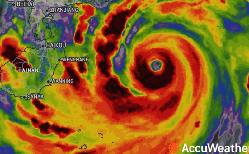
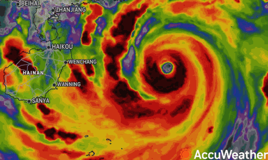
According to the quick news about storm No. 3 released by the National Center for Hydro-Meteorological Forecasting at 6:00 a.m. on September 7, the center of the storm is located at about 20.4 degrees North latitude; 108.3 degrees East longitude, 160km from the coast of Quang Ninh - Hai Phong.
The strongest wind is level 14 (150-166km/h), gusting to level 17. It is forecasted that in the next 3 hours, the storm will move in the West Northwest direction, at a speed of about 15-20km/h.
By 2:00 p.m. today, September 7, the storm is expected to continue moving west-northwest at a speed of 15-20km/h and begin to make landfall in the northeastern region. Wind force is level 11, gusting to level 13.
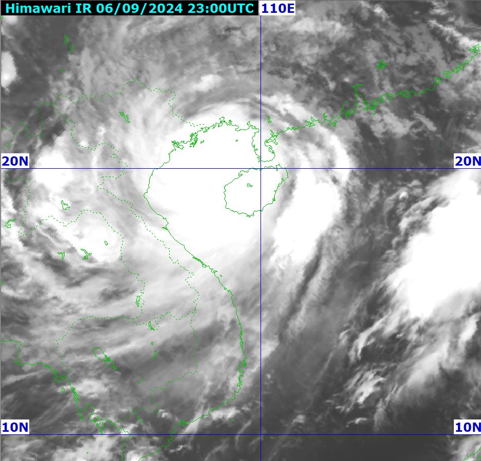
The danger zone includes the area north of latitude 18.5 degrees North and west of longitude 111.0 degrees East. The disaster risk level is level 4 for the area north of the Gulf of Tonkin, coastal waters and mainland of Quang Ninh, Hai Phong; level 3 for the area south of the Gulf of Tonkin, coastal waters and mainland of Thai Binh, Nam Dinh, Ninh Binh and Thanh Hoa.
Due to the impact of storm No. 3, coastal areas from Quang Ninh to Thanh Hoa have strong winds of level 6-7, then increasing to level 8-9, areas near the storm center have winds of level 10-12, gusting to level 14; areas deep inland in the Northeast have strong winds of level 6-8, gusting to level 9-11. The strongest winds are from morning to evening on September 7.
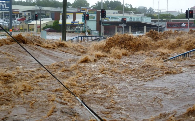
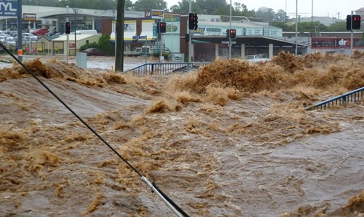
From now until the morning of September 9, the Northern region and Thanh Hoa will experience a widespread heavy rain with total rainfall ranging from 100-350mm, with some places experiencing over 500mm. The heaviest rain in the Northeast will be concentrated during the day and night of September 7; in the Northwest from the evening of September 7-8.
Due to the impact of the widespread storm circulation, in the Northwest region, the area from Nghe An to Thua Thien Hue needs to be on guard against the risk of thunderstorms, tornadoes, whirlwinds and strong gusts of wind. People and tourists need to proactively update weather forecast information to respond, promptly deploy safety measures, and limit going out to avoid loss of life and property.

Weather forecast for September 7 in 10 tourist cities of Vietnam:
Hanoi
Lowest temperature: 25-26 degrees Celsius.
Highest temperature: 28-31 degrees Celsius.
Thunderstorms during the day, heavy rainfall. Showers and thunderstorms at night, locally heavy rain.
Ha Long
Lowest temperature: 25-27 degrees C.
Highest temperature: 28-31 degrees C.
Day and night with heavy thunderstorms and strong winds.
Ninh Binh
Lowest temperature: 25-27 degrees C.
Highest temperature: 27-31 degrees C.
Day and night with heavy thunderstorms and strong winds.
Hue
Lowest temperature: 23-26 degrees C.
Highest temperature: 32-37 degrees C.
Hot and sunny during the day with some rain. Partly cloudy at night with no rain.
Danang
Lowest temperature: 25-29 degrees C.
Highest temperature: 32-37 degrees C.
Daytime clouds clear, light sunshine. Night time less clouds, clear sky.
Nha Trang
Lowest temperature: 24-26 degrees Celsius.
Highest temperature: 29-35 degrees Celsius.
Hot day, high UV index. Partly cloudy night, no rain.
Dalat
Lowest temperature: 19-24 degrees C.
Highest temperature: 24-29 degrees C.
Day and night with showers and thunderstorms, strong winds.
Ho Chi Minh City
Lowest temperature: 24-26 degrees Celsius.
Highest temperature: 31-33 degrees Celsius.
During the day there will be scattered showers and thunderstorms with strong gusts of wind. No rain at night.
Vung Tau
Lowest temperature: 24-27 degrees C.
Highest temperature: 31-32 degrees C.
During the day there will be showers and thunderstorms, strong gusts of wind. At night there will be few clouds, no rain.
Phu Quoc
Lowest temperature: 25-28 degrees C.
Highest temperature: 29-30 degrees C.
Day and night with heavy showers and thunderstorms, strong winds.