According to storm news, the latest low pressure from the Joint Typhoon Warning Center (JTWC), the low pressure in the Pacific Ocean is moving towards the mainland.
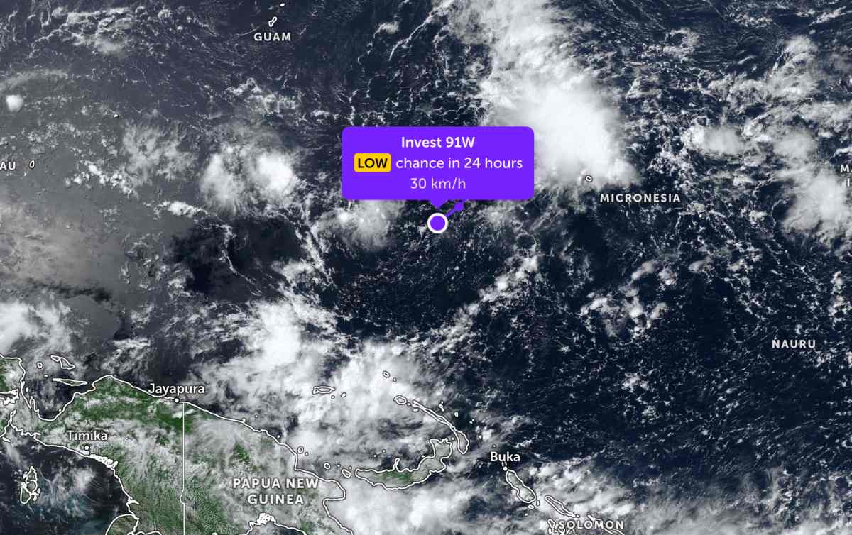
As of the morning of April 30, the low pressure bearing the symbol Invest 91W is currently located in the Western Pacific. The low pressure is moving southwest, towards the mainland area of Papua New Guinea.
The strongest wind near the center of the low pressure reached 30 km/h. JTWC forecasts that the low pressure is unlikely to strengthen into a storm in the next 24 hours.
Because it is still quite far from the mainland, the low pressure only causes thunderstorms at sea, not affecting much the mainland around the area.
In the East Sea, according to the National Center for Hydro-Meteorological Forecasting, on April 30, the cold air moving from the North has gradually weakened.
In the North and South of the Gulf of Tonkin, the weather will have showers and thunderstorms in some places, visibility over 10km. Northeast wind operating at level 4-5, especially in the North sometimes reaching level 5, gusting at level 6-7, causing sea waves to fluctuate from 1.5 to 2.5m.
The area from South Quang Tri to Khanh Hoa maintains a relatively stable state. The sea area from South Quang Tri to Quang Ngai has showers and thunderstorms in some places, while from Gia Lai to Khanh Hoa there is no rain. Northeast wind level 3-4, waves commonly from 0.5 to 2.0m high.
In the southern sea area, from Lam Dong to Ca Mau, there is no rain, the weather is favorable for maritime activities with a visibility of over 10km, level 4 northeast to east wind, waves from 0.5 to 1.5m high. The area from Ca Mau to An Giang has showers in some places, light wind, low waves from 0.5 to 1.0m.
In the offshore sea areas, the North East Sea has showers and thunderstorms in some places, northeast wind level 4-5, waves 1.5-2.5m high. Meanwhile, the Central and Southern East Sea regions, including Hoang Sa special zone and Truong Sa special zone, have less fluctuating weather, mainly no rain or scattered showers, northeast wind level 3-4, waves from 0.5 to 1.5m high.
Especially the Gulf of Thailand area has showers and thunderstorms in some places, light wind, calm sea with waves from 0.5 to 1.0m high.
People and tourists planning to visit these sea areas should pay attention to weather forecasts. Avoid going out to sea when the sea is rough and follow local instructions to ensure safety throughout the journey.


