Low pressure near the East Sea officially strengthens into a tropical depression

Chí Long |

It is forecast that the tropical depression will continue to strengthen rapidly, with the possibility of becoming a storm near the East Sea.

According to storm news, the latest low pressure from the Philippine Atmospheric, Geophysical and Astronomical Services Administration (PAGASA), the low pressure near the East Sea has strengthened into a tropical depression.

As of 4 am this morning (local time), the center of the tropical depression is located at about 12.2 degrees North latitude - 144.6 degrees East longitude, 2,085 km east of Visayas, outside the Philippine Area of Responsibility (PAR).

The strongest wind near the center of the tropical depression reached 55 km/h, gusting up to 70 km/h. PAGASA forecasts that the tropical depression will strengthen into a storm this afternoon, June 19.

The tropical depression is moving in a westerly direction at a speed of 15 km/h. Strong winds extend outside the center up to 280 km.

Cập nhật hướng đi của áp thấp nhiệt đới gần Biển Đông. Ảnh: PAGASA
Update on the direction of the tropical depression near the East Sea. Photo: PAGASA

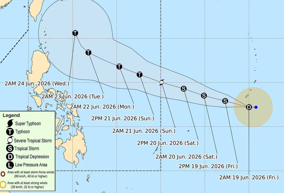
It is forecast that the tropical depression will move generally northwest and will enter the Philippine Area of Responsibility (PAR) from tomorrow (June 20) and Sunday morning (June 21).

Once in PAR, the tropical storm will be locally named Francisco. While moving across the Philippine Sea, it will return northwest on Wednesday (June 24) south of Japan.

It is forecast that the tropical depression is likely to directly affect the weather in the Philippines in the next 3 days.

People and tourists planning to visit the Philippines during this time should pay attention to weather forecasts. Regularly check flight schedules and follow local instructions to ensure safety throughout the journey.

Chí Long
TIN LIÊN QUAN

Update on the location of two low pressure areas near the East Sea

|

Two low pressure systems are continuing to move closer to the area of responsibility of the Philippines and the South China Sea.

Low pressure connects low pressure formation towards the East Sea

|

A new low pressure area has formed, following the low pressure area Invest 92W towards the East Sea.

Low pressure near the East Sea is likely to strengthen in the next 24 hours

|

Forecast low pressure near the East Sea has the potential to strengthen into a tropical depression or storm.

Update on the location of two low pressure areas near the East Sea

Chí Long |

Two low pressure systems are continuing to move closer to the area of responsibility of the Philippines and the South China Sea.

Low pressure connects low pressure formation towards the East Sea

Chí Long |

A new low pressure area has formed, following the low pressure area Invest 92W towards the East Sea.

Low pressure near the East Sea is likely to strengthen in the next 24 hours

Chí Long |

Forecast low pressure near the East Sea has the potential to strengthen into a tropical depression or storm.