New low pressure forecast to continuously appear near the East Sea

Chí Long |

A new low pressure area is forecast to appear near the Philippine Area of Responsibility (PAR), likely to strengthen in the next 24 hours.

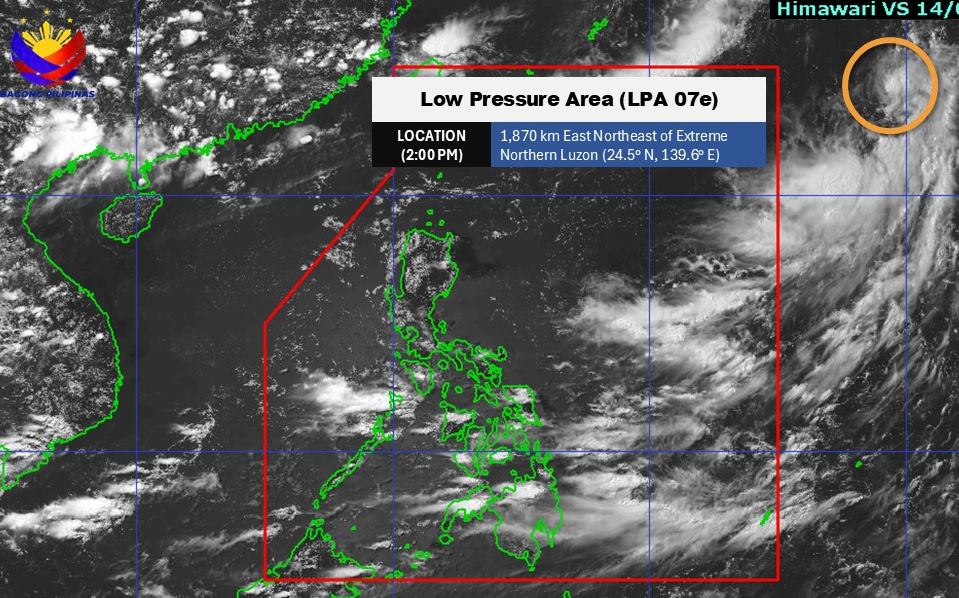
According to the new weather forecast from the Philippine Atmospheric, Geophysical and Astronomical Services Administration (PAGASA), as of 2:00 p.m. on July 14 (local time), the center of the low pressure was at about 24.5 degrees North latitude - 139.6 degrees East longitude, about 1,870km East - Northeast of the northernmost tip of Luzon.

The low pressure is likely to develop into a tropical depression in the next 24 hours.

Ap thap moi xuat hien gan Bien Dong. Anh: PAGASA
A new low pressure area has appeared near the East Sea. Photo: PAGASA

In the sea area of Vietnam, on July 14, the South China Sea (including Truong Sa special zone) and the Gulf of Thailand will have scattered showers and thunderstorms.

It is forecasted that on the day and night of July 14, scattered showers and thunderstorms will occur in the areas north of the Gulf of Tonkin, south of the East Sea (including the Truong Sa special zone), the sea area from Lam Dong to Ca Mau, and the Gulf of Thailand. During thunderstorms, there is a possibility of tornadoes and strong gusts of wind. Waves are over 2.0m high.

PAGASA forecasts that during the week of July 14-20, two low pressure areas will appear in the Philippine Area of Responsibility. Of which, the first low pressure may form east of PAR and move to the northernmost tip of Luzon. The low pressure is likely to develop into a tropical depression.

Du bao cac ap thap hinh thanh va gay anh huong toi Bien Dong trong 2 tuan toi. Anh: PAGASA
Low pressure is forecast to form and affect the East Sea in the next 2 weeks. Photo: PAGASA

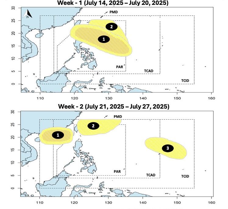
Meanwhile, a second low pressure is expected to form in the Northeast of the PAR but is unlikely to develop into a tropical storm.

During the week of July 21-27, the second tropical depression is expected to move into the East Sea. The low pressure is assessed to have little chance of developing into a storm.

The second low pressure will enter the Taiwan area (China).

The third low pressure is forecast to appear outside the PAR and is also unlikely to strengthen into a tropical depression.

People and tourists should pay attention to weather forecasts. Follow local instructions to avoid storms that can affect if you have a travel plan during this time.

Chí Long
TIN LIÊN QUAN

Tropical depression officially strengthens into storm Nari

|

According to the latest storm information from the Joint Typhoon Warning Center (JTWC), a tropical depression is officially named Nari, meaning river in Korean.

New low pressure approaches the East Sea right after storm No. 2

|

Storm No. 2 Today has weakened into a low pressure area, while a new low pressure area has appeared near the northern part of the East Sea.

Weather forecast for today, July 10: Low pressure trough causes very heavy rain in the North

|

Weather forecast for today, July 10, the North will receive heavy rain lasting at least four days (July 10-14). Some places will have over 300mm of rain.

Tropical depression officially strengthens into storm Nari

Ninh Phương |

According to the latest storm information from the Joint Typhoon Warning Center (JTWC), a tropical depression is officially named Nari, meaning river in Korean.

New low pressure approaches the East Sea right after storm No. 2

Chí Long |

Storm No. 2 Today has weakened into a low pressure area, while a new low pressure area has appeared near the northern part of the East Sea.

Weather forecast for today, July 10: Low pressure trough causes very heavy rain in the North

Chí Long |

Weather forecast for today, July 10, the North will receive heavy rain lasting at least four days (July 10-14). Some places will have over 300mm of rain.