According to the National Center for Hydro-Meteorological Forecasting, at 7:00 p.m. on July 4, the center of the tropical depression was at about 19.9 degrees North latitude - 118.3 degrees East longitude. The strongest wind near the center of the tropical depression is level 7 (5061km/h), gusting to level 9. The low pressure moved slowly in the West direction, at a speed of about 510km/h.
It is forecasted that by 7:00 p.m. on July 5, the tropical depression will move northwest at a speed of about 5-10km/h and is likely to strengthen into a storm.
If it becomes a storm, tropical storm No. 2 in the East Sea will have the international name DANAS (the name in the Philippines is Bising).
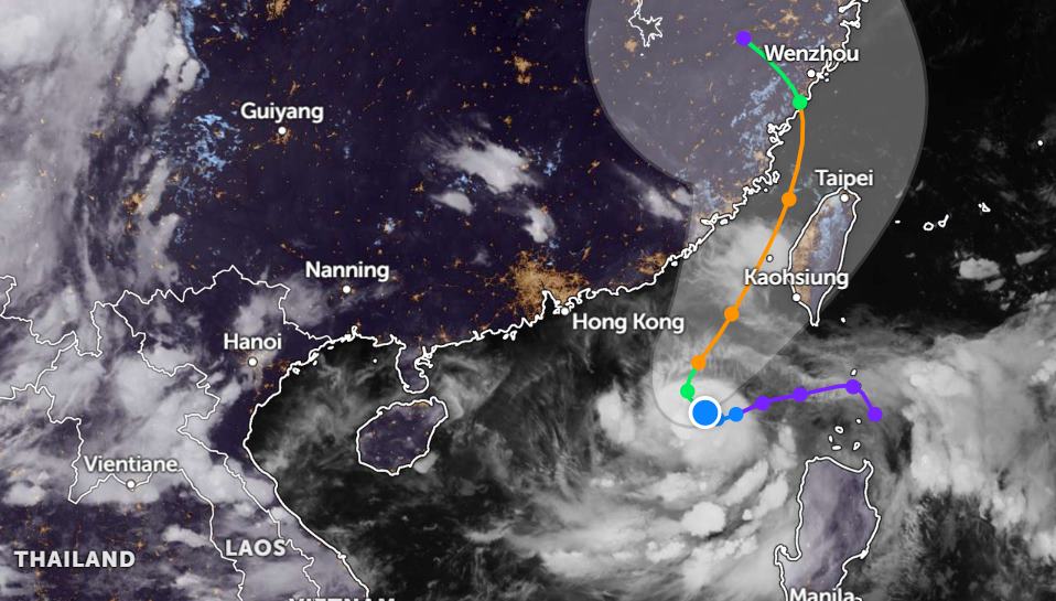
The center of the storm is located at about 20.9 degrees North latitude - 117.4 degrees East longitude; in the northeastern sea of the East Sea. The strongest wind near the storm center is level 8-9, gusting to level 11. Natural disaster risk level: level 3 for the northeastern sea area of the North East Sea.
By 7:00 p.m. on July 6, storm DANAS continued to move in the North Northeast direction at a speed of about 10km/h and was likely to strengthen.
The center of the storm is located at about 22.7 degrees North latitude - 118.3 degrees East longitude, in the northeastern sea of the East Sea. The strongest wind near the storm center is level 10, gusting to level 12. Storm DANAS will affect the northeastern sea area of the North East Sea.
It is forecasted that in the next 48 to 72 hours, the storm will move in a North-Northeast direction at a speed of about 20km/h and will have little change in intensity.
Due to the influence of the tropical depression about to become a storm in the East Sea, the northeastern sea area of the North East Sea will have thunderstorms, strong winds of level 67, then increase to level 89, gusting to level 11. The sea is very rough, with waves 3.05.0m high.
Ship operating in the danger zone is at high risk of being affected by thunderstorms, whirlwinds, strong winds and large waves.
People and tourists planning to travel to Taiwan (China), Hong Kong (China), and the Southeast provinces of China should pay attention to weather forecasts and check flight schedules to avoid storms affecting their travel.


