According to a new weather forecast from the Philippine Atmospheric, Geophysical and Astronomical Services Administration (PAGASA), a new low pressure has formed within the Philippine Area of Responsibility (PAR).
As of 8:00 a.m. this morning, October 14 (local time), the center of the low pressure was at about 14.6 degrees North latitude - 122.9 degrees East longitude, in the coastal area of Vizons, Camarine Norte, Philippines. The low pressure is forecast to be unlikely to develop into a tropical depression in the next 24 hours.
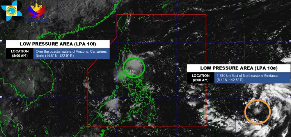
Meanwhile, another low pressure is strengthening outside the PAR. The center of the low pressure is located at about 8.4 degrees North latitude - 142.5 degrees East longitude, about 1,780 km east of the southern part of Mindanao. The low pressure is likely to develop into a tropical depression in the next 24 hours.
Based on PAGASA's storm forecast for the period from October 13 to October 26, this low pressure is likely to strengthen into Typhoon Ramil (local name in the Philippines). The storm will sweep across the Philippines into the South China Sea and become the 12th storm, heading towards the Gulf of Tonkin.
Due to the influence of the low pressure and the East wind, Metro Manila, Luzon and neighboring areas will have scattered thunderstorms. Heavy rain can cause floods and landslides.
In the East Sea, according to the National Center for Hydro-Meteorological Forecasting, on the morning of October 14, there were scattered showers and thunderstorms in the Gulf of Tonkin and the Gulf of Thailand.
It is forecasted that during the day and night of October 14, the Gulf of Tonkin, the sea area from Ca Mau to An Giang and the Gulf of Thailand will have scattered showers and thunderstorms. During thunderstorms, there is a possibility of tornadoes, strong gusts of wind of level 6-7 and waves over 2.0m high.
All ships operating in the above areas are at risk of being affected by tornadoes and strong gusts of wind.
People and tourists planning to visit these coastal areas or areas affected by low pressure should pay attention to weather forecasts. Follow local instructions to avoid storms and big waves that are dangerous throughout the journey.


