New low pressure is about to enter the East Sea after storm No. 15

Chí Long |

A new low pressure has formed, likely to enter the East Sea after storm No. 15.

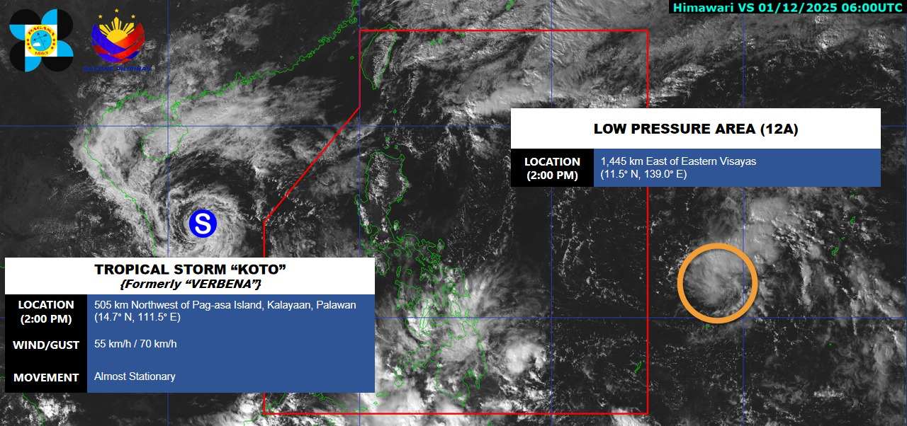
According to the latest weather forecast from the Philippine Atmospheric, Geophysical and Astronomical Services Administration (PAGASA), a new low pressure has formed within the Philippine Area of Responsibility (PAR).

As of 2:00 p.m. this afternoon (local time), the center of the low pressure was at about 11.5 degrees North latitude - 139.0 degrees East longitude, about 1,445 km east of the Visayas Islands. The low pressure is likely to develop into a tropical depression in the next 24 hours.

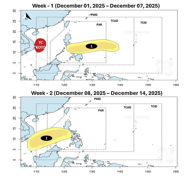
PAGASA forecasts that this low pressure will sweep across the Philippine mainland and enter the East Sea this week. During the week of December 8-14, the low pressure will move deeper into the southern area of the East Sea, affecting the central and southern seas of Vietnam.

Cap nhat huong di cua ap thap nhiet doi moi hinh thanh gan Bien Dong. Anh: PAGASA
Update the path of the newly formed tropical depression near the East Sea. Photo: PAGASA

Meanwhile, storm No. 15 has weakened into a tropical depression in the East Sea.

According to the National Center for Hydro-Meteorological Forecasting, at 1:00 p.m. this afternoon (Vietnam time), the center of the low pressure was at 14.6 degrees North latitude - 111.3 degrees East longitude, in the Northwest sea of the Central East Sea. The strongest wind is level 7, gusting to level 9. The tropical depression has little movement.

It is forecasted that in the next 12-24 hours, the tropical depression will move South-Southwest at a speed of about 5 km/h. The center of the low pressure is about 200 km from the Gia Lai-Dak Lak shore. The strongest wind will reach level 6, gusting to level 8.

Vi tri cua bao so 15 va ap thap gan Bien Dong. Anh: PAGASA
Location of storm No. 15 and low pressure near the East Sea. Photo: PAGASA

Due to the influence of the tropical depression, the northwest of the Central East Sea and off the coast of Gia Lai - Dak Lak: wind level 6-7, gusts 9; waves 2-4 m, rough seas.

Ship in the danger zone is at risk of thunderstorms, whirlwinds, strong winds, and large waves. People and tourists should avoid going to sea at this time and follow local instructions to avoid storms and large waves at sea that are dangerous.

Chí Long
TIN LIÊN QUAN

Storm No. 16 quickly entered the East Sea right after storm No. 15 weakened

|

The latest storm news shows that a low pressure is likely to strengthen into a tropical depression and form a new storm in December, right after storm No. 15.

Weather forecast for today 1.12: Storm No. 15 approaches the mainland, the North gradually warms

|

Weather forecast for today 1.12, storm No. 15 approaches the mainland of the Central region, while the weather in the North and North Central regions will gradually warm due to weakening cold air.

Weather forecast for today, November 30: Storm No. 15 is 340 km from Gia Lai - Dak Lak

|

Weather forecast for today, November 30, storm No. 15 approaches the mainland of the Central region, with waves 7 m high.

Storm No. 15 turns towards the tropical depression in the East Sea

|

Storm No. 15 is forecast to turn south, approaching the area affected by the tropical depression in the East Sea.

Storm No. 16 quickly entered the East Sea right after storm No. 15 weakened

Ninh Phương |

The latest storm news shows that a low pressure is likely to strengthen into a tropical depression and form a new storm in December, right after storm No. 15.

Weather forecast for today 1.12: Storm No. 15 approaches the mainland, the North gradually warms

Chí Long |

Weather forecast for today 1.12, storm No. 15 approaches the mainland of the Central region, while the weather in the North and North Central regions will gradually warm due to weakening cold air.

Weather forecast for today, November 30: Storm No. 15 is 340 km from Gia Lai - Dak Lak

Chí Long |

Weather forecast for today, November 30, storm No. 15 approaches the mainland of the Central region, with waves 7 m high.

Storm No. 15 turns towards the tropical depression in the East Sea

Chí Long |

Storm No. 15 is forecast to turn south, approaching the area affected by the tropical depression in the East Sea.