The latest storm forecast from the Philippine Atmospheric, Geophysical and Astronomical Services Administration, at 2:00 a.m. on December 2, a low pressure was at about 12.6 degrees north latitude and 136.5 degrees east longitude, about 1,290 km east of Eastern Visayas.
This low pressure is expected to strengthen into a tropical depression in the next 24 hours.
According to PAGASA's typhoon forecast, there may be 1-2 typhoons forming or entering the Philippine Forecast Area (PAR) in December. The next two storms will be named Wilma and Yasmin, in which Wilma could become the 16th storm if it enters the East Sea and is monitored by Vietnam.
The latest storm forecasts show that Depression 12a - the predecessor of Wilma - is likely to enter PAR as early as today (December 2) or December 3, then move through the Caraga - Visayas - Southern Luzon area over the weekend.
During the period of December 8-14, the tropical depression system (most likely to have strengthened) is forecast to continue passing through Mindoro - Palawan, leaving PAR and entering the East Sea. The main direction of movement is towards the South Central Coast of Vietnam.
Meanwhile, storm No. 15 has weakened into a tropical depression in the East Sea.
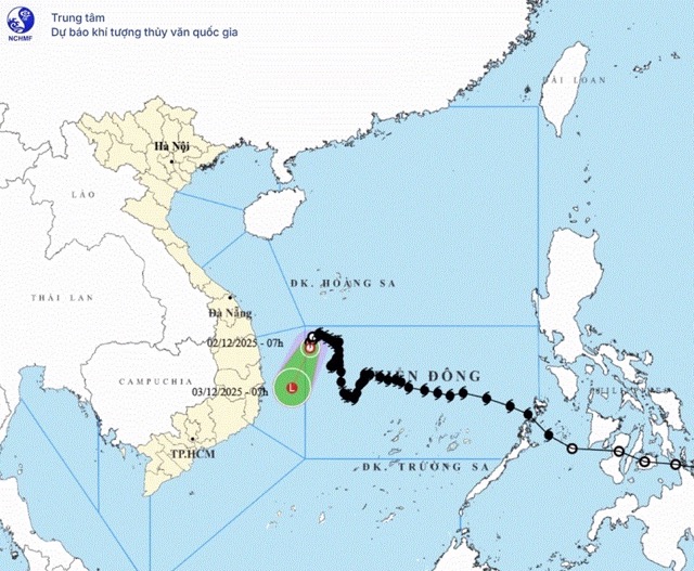
According to the weather forecast from the National Center for Hydro-Meteorological Forecasting, on the morning of December 2, the center of the tropical depression was located at 14.2°N - 111.2°E, in the Northwest sea of the Central East Sea, with the strongest wind of level 6, gusting to level 8, moving slowly in the South-Southwest direction at about 5km/h.
Weather forecast for the next 24 hours, the tropical depression will continue to move in the South-Southwest direction at a speed of 5-10km/h and by 07:00 on December 3, it will be at about 12.7°N - 110.5°E, in the waters of Dak Lak - Khanh Hoa province, gradually weakening into a low pressure area with an intensity below level 6.
The dangerous area at sea during this period is determined from 12.5°N to 15.0°N and from 110.0°E to 112.0°E, level 3 natural disaster risk, affecting the northwest sea area of the Central East Sea and the sea off Gia Lai - Dak Lak.
This area has strong winds of level 6, gusts of level 8, waves 2.0-4.0m high, rough seas; ships operating in dangerous areas are at high risk of being affected by thunderstorms, whirlwinds, strong winds and large waves.
People and tourists planning to go to sea or travel by boat should closely monitor weather reports and proactively adjust their itineraries to ensure safety during rough seas due to the influence of tropical depressions or storms.


