
According to storm news, the latest low pressure from the Philippine Atmospheric, Geophysical and Astronomical Services Administration (PAGASA), the tropical depression near the East Sea has officially strengthened into a storm. The storm is called Jangmi.
As of 10 am this morning (local time), the storm's center was located at about 8.6 degrees North latitude - 138.1 degrees East longitude, about 1,300 km northeast of Mindanao. The storm is moving in a Northwest direction at a speed of 10 km/h, heading towards the East Sea.
The strongest wind near the storm center reached 65 km/h, gusting up to 80 km/h. Strong winds extended outside the storm center up to 380 km.
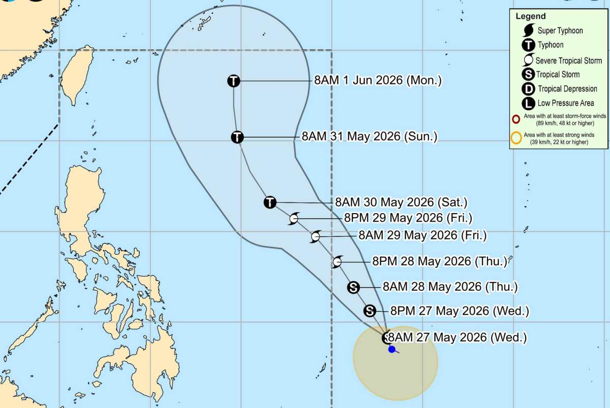
Due to being far from the mainland, the storm only caused thunderstorms and big waves at sea, and did not significantly affect the surrounding mainland areas.
Typhoon Jangmi is forecast to move northwest from now until May 28th, then continue to head towards the Philippine Sea area before gradually moving north at the weekend. This system is expected to enter the Philippine Area of Surveillance (PAR) on the evening of May 28th and will be named Domeng locally.
Typhoon Jangmi is forecast to maintain strong tropical storm intensity when entering PAR and may strengthen further, reaching typhoon level on May 30 in the Philippine waters.
Although the possibility of direct landfall is underestimated, the outer circulation of the storm can still cause bad weather in the northernmost part of Luzon, with the highest wind warning level possibly reaching signal number 1.
In addition, rough seas and high waves may appear in the coastal areas of Northern Luzon this weekend, and the risk of issuing strong gust warnings at sea is also being considered.
The storm is also likely to increase the activity of the Southwest monsoon from May 30, causing widespread rain and strong winds.
The meteorological agency also recommends that people and tourists in coastal areas, especially the northern Philippines sea area and localities affected by the Southwest monsoon, closely monitor weather forecasts in the coming days. Tourism, fishing and sea travel activities may be affected by high waves, strong winds and prolonged thunderstorms, posing potential safety risks.


