According to storm news, the latest low pressure from the Joint Typhoon Warning Center (JTWC), a tropical depression in the Indian Ocean is about to strengthen into a storm.
The tropical depression with symbol Invest 90B is currently near the mainland of Sri Lanka. The strongest wind near the center of the tropical depression reaches 55 km/h and is likely to continue to strengthen. JTWC forecasts that this tropical depression is highly likely to develop into a storm in the next 24 hours.
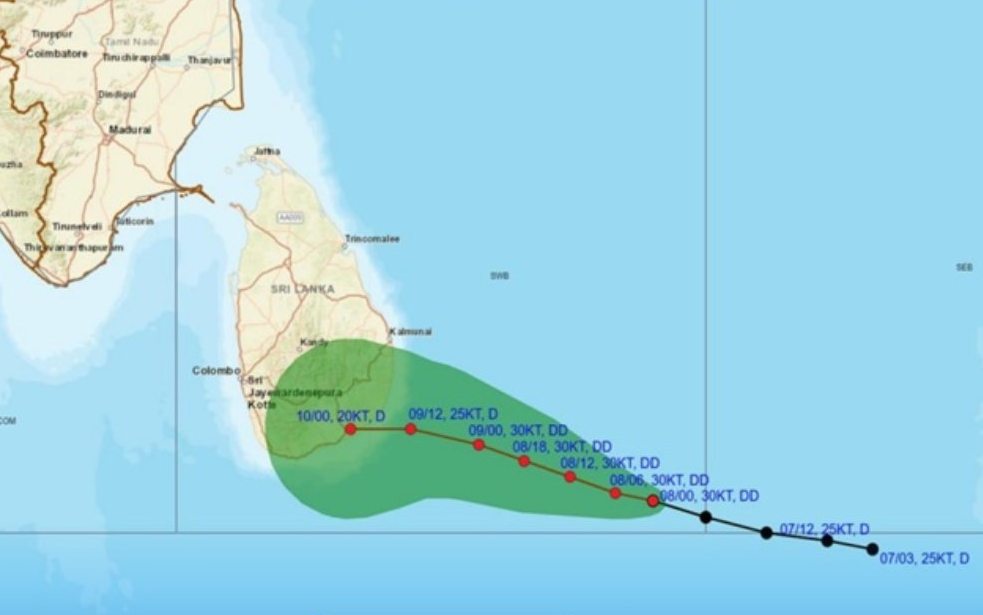
The tropical depression will enter the Bay of Bengal and may make landfall in Sri Lanka tomorrow, January 9, between the Hambantota and Kalmunai areas. It is forecast that the depression will cause more than 100mm of rain in the eastern provinces and Uva. Nearby areas will have rainfall of 50-75mm and strong winds of 50-60 km/h, including in Colombo.
Meanwhile, Typhoon Jenna is showing signs of gradual weakening in the Indian Ocean. The center of the typhoon is currently located 972 km southwest of the Cocos Islands (Australia). In the past 6 hours, the typhoon has moved in a Northwest direction at a speed of about 13 km/h. The wave height reached 7m.
The strongest wind near the storm center reaches 85 km/h. Wind intensity continues to gradually decrease in the next 24 hours, then weakens into a tropical depression.
People and tourists planning to visit the Sri Lanka region during this time should pay attention to weather forecasts. Check your flight schedule and follow local instructions to avoid storms affecting your journey.


