The Philippine Department of Meteorology, Geophysics and Astronomy (Pagasa) forecasts that a low pressure area is likely to appear near the East Sea in the period from January 9-15.
PAGASA weather expert Benison Estareja predicts a low pressure area may form in the following days. The low pressure area may affect the region on Sunday (January 11) or Monday (January 12).
The low pressure area will enter the Philippine Area of Responsibility for Weather Forecasting (PAR) and begin to affect the Caraga and Davao regions next week.
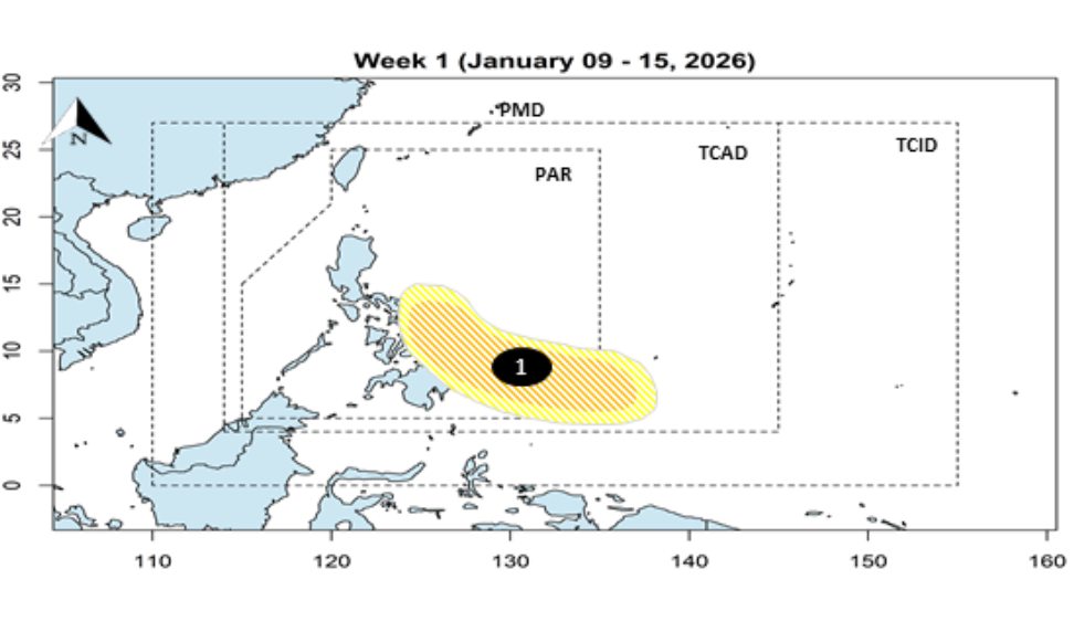
Experts added that in the next week, the low pressure area may move to the area between Eastern Visayas and the Caraga region in the middle of next week. The low pressure area is likely to develop strongly into a tropical depression. At that time, the tropical depression will be named Ada.
PAGASA believes that tropical depression forecasts may still change in the next few days. Meanwhile, currently, no storms or low pressures are being monitored in the Philippine area of responsibility.
Previously, PAGASA forecast that there would be two to eight tropical storms entering the Philippine Area of Responsibility for Typhoon Forecasting (PAR) in the first half of 2026.
According to the National Center for Hydro-Meteorological Forecasting, in January 2026, a tropical depression is unlikely to appear in the East Sea. However, cold air causes strong winds and big waves, causing strong sea waves.
From January 10-11, the area of Nam Quang Tri - Quang Ngai, Truong Sa special zone will have wave heights ranging from 2.0-3.0m. The area of Gia Lai - Khanh Hoa will have wave heights ranging from 2.5-3.5m. The area of North East Sea will have wave heights ranging from 3.0-5.0m. The area of Lam Dong - Ca Mau, Central and South East Sea (including Hoang Sa special zone) will have wave heights ranging from 2.0-4.0m.
From January 12-18, the area of Lam Dong - Ca Mau, South East Sea will have wave heights ranging from 2.0-3.0m. The area of Gia Lai - Khanh Hoa, Central East Sea, Hoang Sa Special Zone, Truong Sa Special Zone will have wave heights ranging from 2.0 - 3.0m. The area of North East Sea will have wave heights ranging from 3.0-5.0m.
From January 10-18, the Lam Dong - Ca Mau area, the East Sea, Hoang Sa special zone and Truong Sa special zone; the South Quang Tri - Khanh Hoa area (January 10-11) will experience large waves, with the potential to affect ships operating at sea.
People and tourists who plan to visit these sea areas should pay attention to weather forecasts. Follow local instructions to ensure safety.


