According to the latest storm news from the Joint Typhoon Warning Center (JTWC), on the morning of January 5, tropical storm No. 12S (formed from tropical depression 11U) is operating strongly in the Indian Ocean. This is the second storm to form in the Indian Ocean since the beginning of 2026, after Typhoon Iggy weakened.
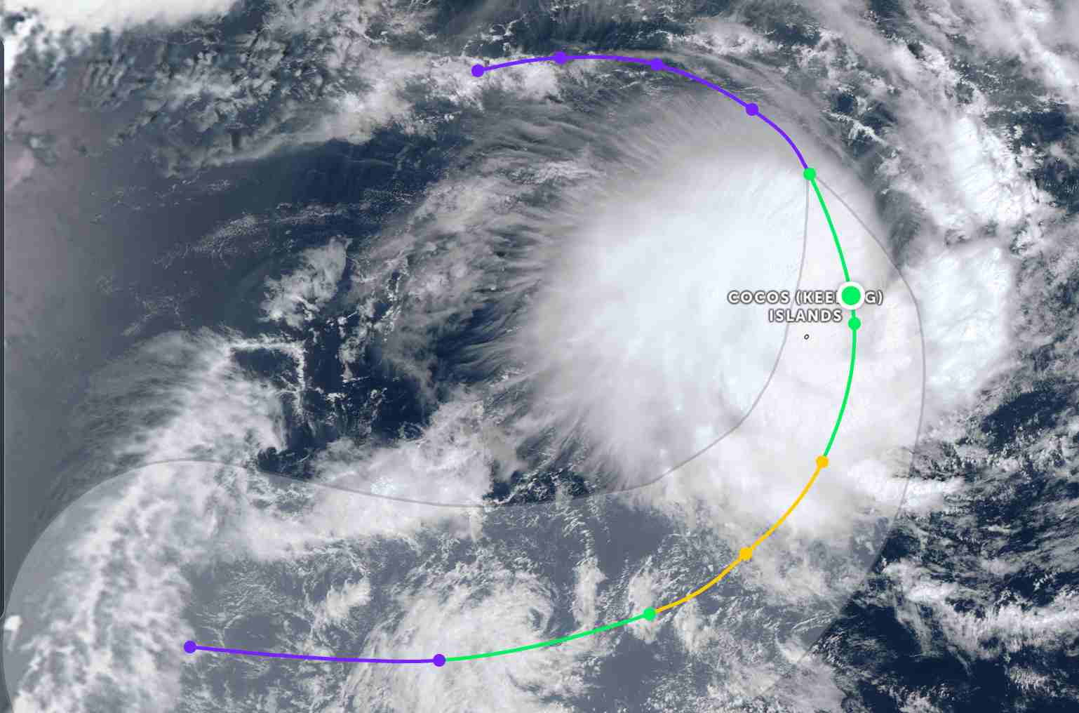
The Australian Meteorological Agency (BOM) identified the storm's center more than 90 km northwest of the Cocos Islands (Australia).
In the past 6 hours, the storm moved in a Southeast direction at a speed of 23 km/h. The maximum wave height reached 5.8 m.
The strongest wind near the storm center reaches 75 km/h. Forecast for the next 12 hours, storm 12S will move in a South-Southeast direction, then change direction to move in a South-Southwest direction before bend direction to the West orbit in the next 2 days.
In the next 48 hours, tropical storm 12S will strengthen fiercely, with the strongest wind reaching 95 km/h tomorrow morning, January 6.
By January 7, storm 12S will gradually weaken. However, cao is forecast to cause heavy rain and strong gusts of wind for Cocos Island in the next 3 days.
Meanwhile, in the East Sea, according to the National Center for Hydro-Meteorological Forecasting, today, January 5, the North East Sea area (including Hoang Sa special zone) has Northeast wind level 5, sometimes level 6, gusting level 7-8; from near dawn on January 6, it strengthens to level 6, gusting 7-8. Waves 2.0-4.0m high. Sea rough.
The sea area from Gia Lai to Dak Lak and the Central East Sea area has Northeast wind level 5, sometimes level 6, gusting 7-8. Waves 2.0-4.0m high. Sea rough.
The sea area from Khanh Hoa to Ca Mau and the sea area southwest of the East Sea (including the sea area west of the Truong Sa special zone) has Northeast wind level 6, gusts 7-8. Waves 3.0-5.0m high. Strong sea waves.
Gulf of Tonkin (near morning of January 6th) has northeast winds gradually strengthening to level 6, gusting 7-8m. Waves 2.5-3.5m high. Sea rough.
In addition, the Central and South East Sea areas (including the Truong Sa special zone) will have scattered showers and thunderstorms. In thunderstorms, there is a possibility of tornadoes and strong gusts of wind.
On January 6th, day and night, in the Gulf of Tonkin, the Northeast wind will be strong at level 6, gusting at level 7-8, waves 2.5-3.5m high, rough seas. The North East Sea area (including Hoang Sa special zone) will have strong Northeast wind at level 6, sometimes level 7, gusting at level 8-9, waves 3.0-5.0m high, rough seas.
The area from South Quang Tri to Khanh Hoa and the Central East Sea area will have Northeast winds gradually strengthening to level 6, gusting to level 7-8, sea waves 3.0-5.0m high, rough seas. The sea area from Lam Dong to Ca Mau, the western sea area of the South East Sea (including the western sea area of Truong Sa special zone) will have Northeast winds gradually strengthening to level 6, sometimes level 7, gusting to level 8-9, sea waves 4.0-6.0m high, rough seas.
People and tourists who plan to visit these sea areas should pay attention to weather forecasts. Avoid going out to sea when the sea is rough and follow local instructions to ensure safety.


