According to the latest storm news from the Philippine Atmospheric, Geophysical and Astronomical Services Administration (PAGASA), Typhoon Nuri has a complex path in the Pacific Ocean, outside the Philippine Responsibility Area.
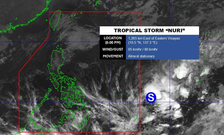
As of 8:00 PM on March 11 (local time), the storm's center was located at about 10.5 degrees North latitude - 137.3 degrees East longitude, about 1,265 km east of the Eastern Visayas. The strongest wind near the storm's center reached 65 km/h, gusting up to 80 km/h.
The storm is almost motionless. Then, the storm will suddenly turn west-northwest to northeast, further away from the Philippine area of responsibility.
The storm is forecast to have little chance of making landfall in the Philippines in the coming days.
In the East Sea, according to the National Center for Hydro-Meteorological Forecasting, today, March 11, at Huyen Tran station, strong Northeast wind at level 6, gusting at level 7 was recorded.
Forecast for the next 24 hours (night of the 11th and day of the 12th), the Northern East Sea area, including the Hoang Sa special zone, will have level 5 Northeast wind, sometimes level 6; from the 12th, it will gradually strengthen to level 6, gusting to level 7-8, rough seas, waves 2.0-4.0m high.
The sea area from Khanh Hoa to Vinh Long and the west of the South East Sea area (including the west of Truong Sa special zone) has level 6 Northeast wind, gusts of level 7-8, rough seas; waves 2.0-4.0m high.
From the afternoon of March 12, the Central East Sea area will have northeast winds gradually strengthening to level 5, sometimes level 6, gusting to level 7-8; rough seas; waves 2.0-4.0m high.
The meteorological agency warns that on the night of March 12 and the 13th, the North East Sea area (including the Hoang Sa special zone) will continue to have strong Northeast winds at level 6; especially the sea area in the Northeast at times level 7, gusts level 8-9, strong sea waves; sea waves 2.0-4.0m high.
The sea area from Khanh Hoa to Vinh Long and the west of the South East Sea area (including the west of Truong Sa special zone) maintains level 6 Northeast wind, gusts of level 7-8, rough seas; waves 2.0-4.0m high.
Meanwhile, the Central East Sea area has level 5 Northeast wind, sometimes level 6, gusts level 7-8; rough seas; sea waves are 2.0-4.0m high.
People and tourists in coastal areas need to pay attention to weather forecasts and warnings, limit participating in tourism and sea entertainment activities when there are strong winds and big waves. Transport and sea tourism units need to have plans to ensure safety for tourists, especially for tourist boats, speedboats and water sports activities.


