According to storm news, the latest low pressure from the Philippine Atmospheric, Geophysical and Astronomical Services Administration (PAGASA), Typhoon Sinaku near the East Sea has officially strengthened into a typhoon.
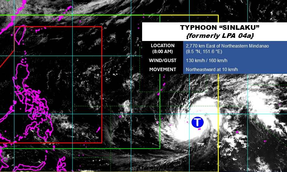
As of 8 am this morning, April 11 (local time), the storm's center was located at about 8.5 degrees North latitude - 151.6 degrees East longitude, about 2,770 km east of the Northeast Mindanao region.
The strongest wind near the storm center reached 130 km/h, gusting up to 160 km/h. The storm is moving in the Northeast direction at a speed of about 10 km/h. The Joint Typhoon Warning Center (JWTC) forecasts that the storm will continue to strengthen and is likely to become a super typhoon in the next 48 hours.
Due to being quite far from the mainland, the storm has not had much impact on the mainland areas of the Philippines.
In the East Sea, according to the National Center for Hydro-Meteorological Forecasting, the Gulf of Tonkin area (North and South Gulf) has no rain, visibility over 10km. South to southeast wind level 4-5, especially in the North sometimes level 6, gusts level 7-8, rough seas. Waves 1.0 - 3.0m high.
Sea area from Quang Tri to Khanh Hoa no rain, visibility over 10km. South to southwest wind level 4-5. Wave height 1.0 - 2.0m. South Central Coast, Southern region and Gulf of Thailand (from Lam Dong to An Giang, including Ca Mau sea area) no rain, visibility over 10km. Light wind, waves 0.5 - 1.5m high.
The area north of the East Sea and Hoang Sa is rainless, visibility over 10km, south to southwest wind level 4-5, waves 1.5 - 3.0m high. The central area of the East Sea is wind level 4, waves 1.0 - 2.0m high. The southern area of the East Sea and Truong Sa has showers and thunderstorms in some places, visibility over 10km, light wind, waves 0.5 - 1.5m high.
People and tourists who plan to operate at sea need to regularly update weather forecast information, comply with recommendations from functional agencies and limit going out to sea when sea conditions are bad to ensure safety.


