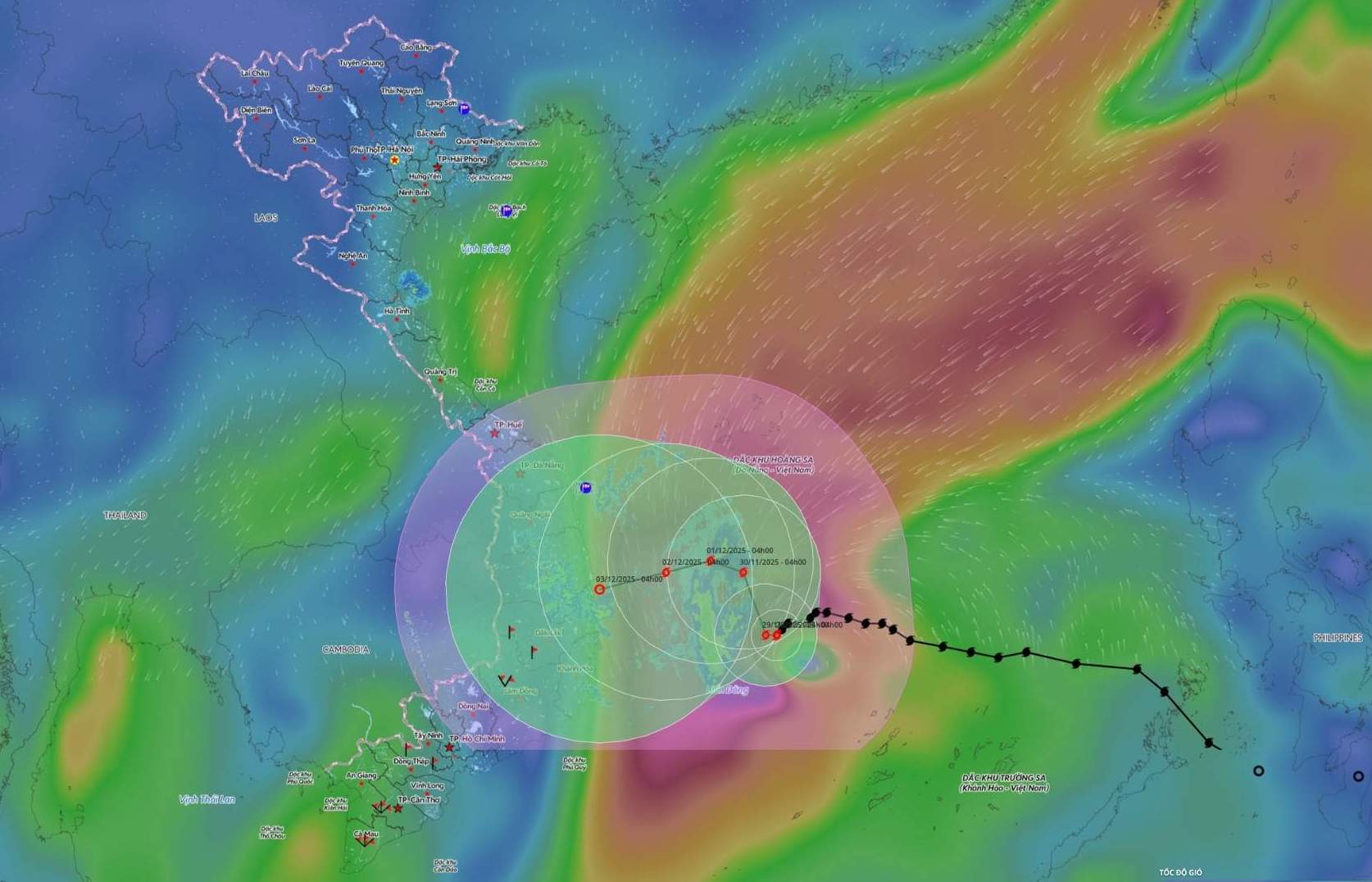
According to the National Center for Hydro-Meteorological Forecasting, at 7:00 a.m. on November 28, the center of storm No. 15 was at about 12.5 degrees North latitude; 113.0 degrees East longitude, about 190km northwest of Song Tu Tay Island. The strongest wind near the storm center is level 10-11 (89-117km/h), gusting to level 14.

It is forecasted that in the next 24 hours, the storm will move west at a speed of about 5km/h. On the morning of November 29, the center of the storm was at about 12.9 degrees north latitude; 112.4 degrees east longitude, in the western sea area of the central East Sea, about 260km northwest of Song Zi Tay Island. The intensity gradually weakened, level 10, gust level 13.
The danger zone is from 11 degrees to 15 degrees north latitude; from 111 to 115.5 degrees east longitude. Level 3 natural disaster risk for the central East Sea area (including the northern sea area of Truong Sa).
It is forecasted that in the next 48 hours, the storm will move north-northeast at a speed of about 5km/h. By November 30, the center of the storm was at about 14.0 degrees north latitude; 112 degrees east longitude, in the northwest sea of the central East Sea, about 300km east of the east coast of Gia Lai province. The intensity gradually weakened, level 9-10, gust level 13.
The danger zone is from 11 degrees north latitude to 15 degrees north latitude; from 110.5 degrees east longitude to 114.5 degrees east longitude. Level 3 natural disaster risk for the western sea area of the central East Sea (including the northwestern sea area of Truong Sa special zone), the sea off the coastal provinces from Gia Lai to Khanh Hoa.
It is forecasted that in the next 72 hours, the storm will move northwest at a speed of 3-5km/h. By December 1, the center of the storm was at about 14.1 degrees north latitude; 111.3 degrees east longitude, in the northwest sea of the central East Sea, about 210km east of the east coast of Gia Lai province. The intensity continues to weaken, level 8-9, gust level 12.
The danger zone is from 11.5 degrees north latitude to 15.5 degrees north latitude; from 110 degrees east longitude to 114 degrees east longitude. Level 3 natural disaster risk for the western sea area of the central East Sea, the offshore sea area of the provinces from Quang Ngai to Dak Lak.
From the next 72 to 120 hours, the storm will move slowly to the west, then it is likely to change direction to the west-southwest at a speed of about 5km/h and the intensity will continue to weaken.
At sea, the central East Sea area (including the sea area north of Truong Sa special zone) has strong winds of level 7-9; the area near the storm's eye has strong winds of level 10-11, gusts of level4; waves 4-6m high, the area near the storm's eye has 7-9m; the sea is very rough.
The offshore sea area from Gia Lai to Khanh Hoa will have strong winds of level 6-7, then increase to level 8, gusting to level 9 Legal waves 5-7m high, rough seas. Ship operating in the above-mentioned dangerous areas are likely to be affected by thunderstorms, whirlwinds, strong winds, and large waves.
In the face of the development of storm No. 15, people and tourists need to pay special attention:
Closely monitor the weather forecast for the coming days.
Follow the instructions of local authorities and do not go to sea when the sea is rough to avoid danger due to gusts of wind, big waves and storms.
Prepare food, water and necessary items, ready to move to a safe place when required.


