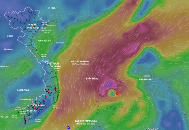
According to the National Center for Hydro-Meteorological Forecasting, at 10:00 a.m. on November 26, the center of the storm was at about 12.5 degrees north latitude; 117.1 degrees east longitude, about 330 km east-northeast of Song Tu Tay Island. The strongest wind near the storm center is level 8-9 (62-88 km/h), gusting to level 11. The storm is moving west-northwest at a speed of 20-25 km/h.

It is forecasted that in the next 24 hours, the storm will move west-northwest at a speed of 10-15 km/h. At 10:00 on November 27, the center of the storm was at about 12.9 degrees north latitude; 114.3 degrees east longitude, in the central East Sea, about 170 km north of Song Tu Tay Island. The storm is likely to strengthen, with the strongest wind level 11, gusting to level 14.
The danger zone is from latitude 11 degrees north to latitude 15 degrees north; longitude 112 degrees east to 119 degrees east. Level 3 natural disaster risk for the central East Sea area (including the northern sea area of Truong Sa).
It is forecasted that in the next 48 hours, the storm will move west-southwest at a speed of about 5 km/h. At 10:00 on November 28, the center of the storm was at about 12.4 degrees north latitude; 113.1 degrees east longitude, in the central East Sea, about 180 km northwest of Song Zi Tay Island. The storm has the strongest winds of level 11, gusting to level 14.
The danger zone is from latitude 11 degrees north to latitude 15 degrees north; longitude 111 degrees east to 116.5 degrees east. Level 3 natural disaster risk for the central East Sea area (including the northern sea area of Truong Sa).
It is forecasted that in the next 72 hours, the storm will move west-northwest at a speed of about 5 km/h. At 10:00 on November 29, the center of the storm was at about 12.9 degrees north latitude; 112.2 degrees east longitude, in the western sea area of the central East Sea. The strongest wind is level 11, gusting to level 14.
The danger zone is from latitude 11 degrees north to 15 degrees north; longitude 110.5 degrees east to 115 degrees east. Level 3 natural disaster risk for the western sea area of the central East Sea (including the northwestern sea area of Truong Sa).
From the next 72 to 120 hours, the storm will move north-northwest at a speed of about 5 km/h and gradually weaken.
At sea, the central East Sea area (including the sea area north of Truong Sa special zone) has strong winds of level 7-8; the area near the storm's eye has strong winds of level 9-11, gusts of level4; waves 4-6 m high, the area near the storm's eye has 7-9 m; the sea is very rough. Ship operating in the above-mentioned dangerous areas are likely to be affected by thunderstorms, whirlwinds, strong winds, and large waves.
In the face of the development of storm No. 15, people and tourists need to pay special attention:
Closely monitor the weather forecast for the coming days.
Follow the instructions of local authorities and do not go to sea when the sea is rough to avoid danger due to gusts of wind, big waves and storms.
Prepare food, water and necessary items, ready to move to a safe place when required.


