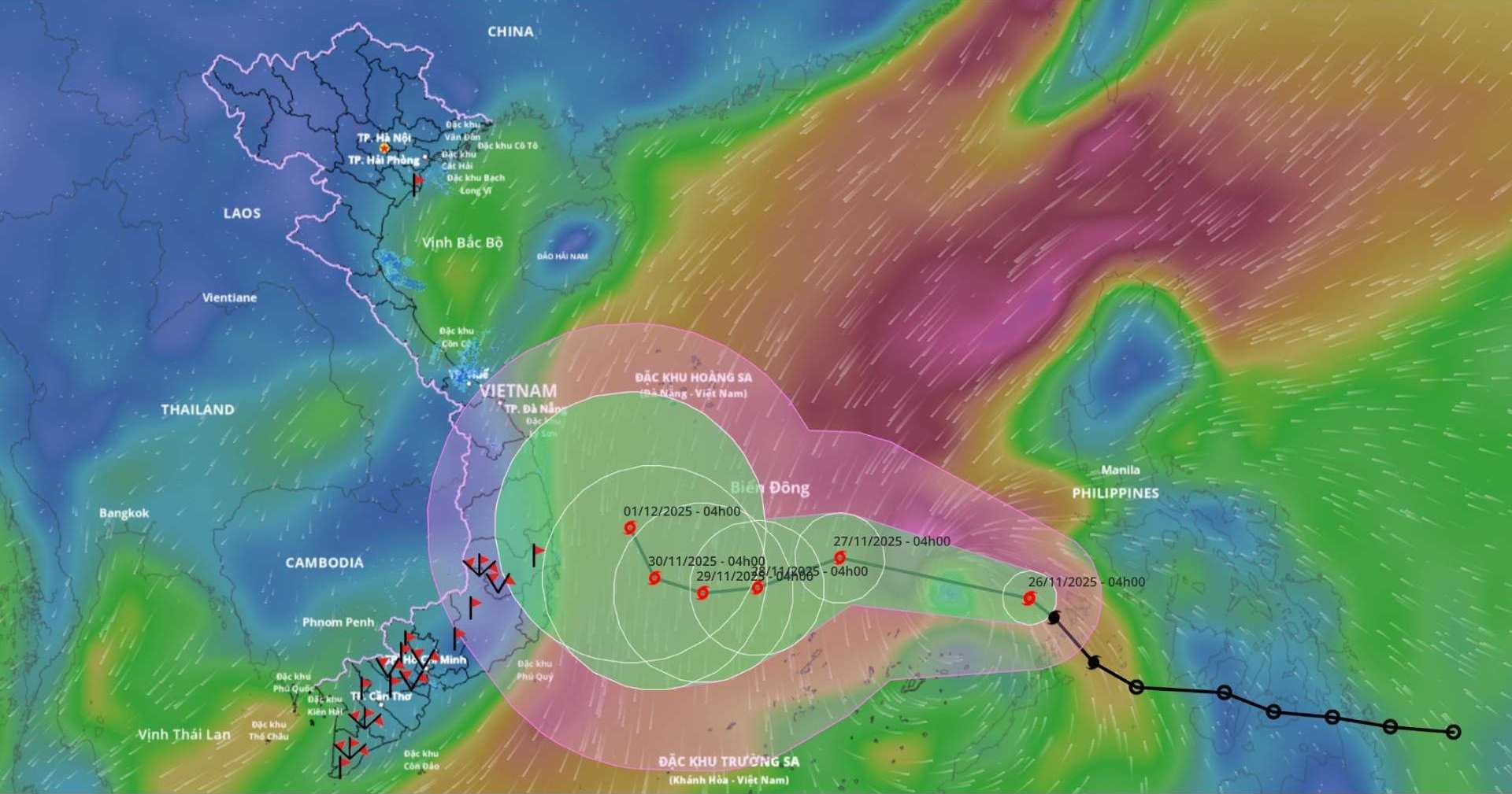
Updated from the National Center for Hydro-Meteorological Forecasting, at 4:00 a.m. on November 26, the center of storm No. 15 was at about 12.2 degrees north latitude; 119.1 degrees east longitude, about 540 km east of Song Tu Tay Island. The strongest wind near the storm center is level 8 (62-74 km/h), gusting to level 10. Moving northwest at a speed of 20-25 km/h.

Forecast of storm developments:
It is forecasted that in the next 24 hours, the storm will move west-northwest at a speed of 15-20 km/h. At 4:00 a.m. on November 27, the location was at about 13 degrees north latitude; 115.2 degrees east longitude, in the central East Sea, about 200 km north-northeast of Song Tu Tay Island. The storm is likely to strengthen, with the strongest wind level 10, gusting to level 13.
The danger zone is from 10 degrees north latitude to 14.5 degrees north latitude; east of the longitude 113.5 degrees east longitude. Level 3 natural disaster risk for the central East Sea area (including the northern sea area of Truong Sa).
It is forecasted that in the next 48 hours, the storm will move west-southwest at a speed of 5-10 km/h. At 4:00 a.m. on November 28, the location was at about 12.4 degrees north latitude; 113.5 degrees east longitude, in the central East Sea, about 150 km north-northeast of Song Tu Tay Island. The storm is likely to strengthen, with the strongest wind level 11, gusting to level 14.
The danger zone is from 10.5 degrees north latitude to 14.5 degrees north latitude; from 112 degrees east longitude to 117 degrees east longitude. Level 3 natural disaster risk for the central East Sea area (including the northern sea area of Truong Sa).
It is forecasted that in the next 72 hours, the storm will move westward, about 5 km/h. At 4:00 a.m. on November 29, the location was at about 12.3 degrees north latitude; 112.4 degrees east longitude, in the western sea area of the central East Sea, about 250 km west-northwest of Song Tu Tay Island. The strongest wind is level 11, gusting to level 14.
The danger zone is from 10.5 degrees north latitude to 14.5 degrees north latitude; from 110.5 degrees east longitude to 115.5 degrees east longitude. Level 3 natural disaster risk for the central East Sea area (including the northern sea area of Truong Sa).
From the next 72 to 120 hours, the storm will move northwest at a speed of about 5 km/h and gradually weaken.
Forecast of the impact of the storm:
At sea, the central East Sea area (including the sea area north of Truong Sa special zone) has strong winds of level 6-7; the area near the storm's eye has strong winds of level 8-10, gusts of level2; waves 4-6 m high, the area near the storm's eye has 6-8 m; the sea is very rough.
During the period of November 27-28, the central East Sea area (including the northern sea area of Truong Sa special zone) is likely to be affected by strong winds of level 11, gusts of level 14; waves 7-9 m high; rough seas. Ship operating in the above-mentioned dangerous areas are likely to be affected by thunderstorms, whirlwinds, strong winds, and large waves.
Given the development of storm No. 15, people and tourists should avoid going to sea or participating in activities at sea during this time.
The storm is moving rapidly and is likely to strengthen. Tourists need to monitor updated forecasts from meteorological agencies, follow evacuation instructions if available and fully prepare plans to prevent natural disasters.


