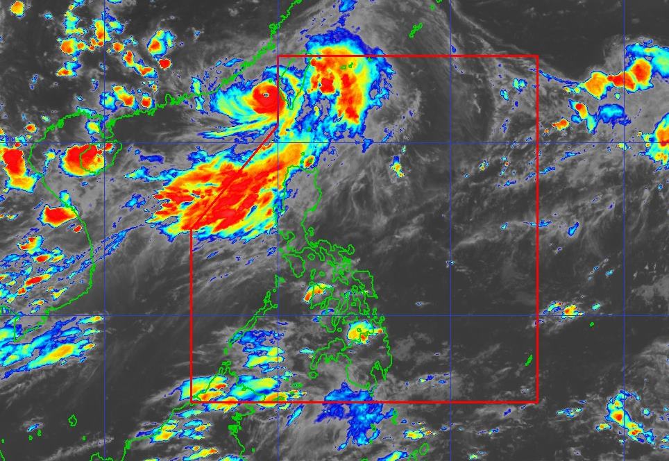
According to the National Center for Hydro-Meteorological Forecasting, as of 4:00 p.m. this afternoon (September 6), storm No. 2 continued to strengthen in the East Sea. The center of the storm is located at about 22.5 degrees North latitude - 119.1 degrees East longitude, in the northeastern sea area of the North East Sea.
The strongest wind near the storm center is level 1112 (103133km/h), gusting to level 15. The storm is moving north-northeast at a speed of about 1520km/h.
It is forecasted that by 4:00 p.m. on July 7, the storm will continue to move north-northeast at a speed of 2025km/h, entering the waters of Fujian province (China), maintaining an intensity of level 11, gusting to level 14. Dangerous area: North of latitude 20.5 Vi Bac and East of longitude 117.0°E. Natural disaster risk level: level 3 in the northeastern sea area of the North East Sea.
Due to the influence of storm No. 2, the North East Sea area (including Hoang Sa special zone) and the sea area from Ca Mau to An Giang will have showers and thunderstorms; the northeastern sea area of the North East Sea will have storms and rain.
In the northeastern sea area of the North East Sea, it is forecasted that tonight the wind will be strong at level 79, near the storm's eye will be strong at level 1012, gusting to level 15. The sea is rough. The waves are generally 2.04.0m high, with waves 4.06.0m high in the area near the center of the storm. The wind is expected to gradually decrease tomorrow.
In the eastern sea area of the North East Sea and the sea area from Khanh Hoa to Ca Mau: strong southwest winds of level 5, sometimes level 6, gusting to level 78. Rough seas. Waves are 2.04.0m high.
The North East Sea area (including Hoang Sa special zone), the northeastern sea area of the Central East Sea, the sea area from Ca Mau to An Giang and the Gulf of Thailand will have showers and thunderstorms.
Meanwhile, on land, scattered thunderstorms will be concentrated in the late afternoon and night, with some heavy rain.
People and tourists planning to travel to coastal areas from Ca Mau to An Giang, Khanh Hoa to Ca Mau or areas near Fujian province (China) should pay attention to weather forecasts. Check flight schedules and follow local instructions to avoid impactful storms.
Weather forecast for tonight and tomorrow, July 7, at:
City. Hanoi
Lowest temperature: 26-28 degrees Celsius.
Highest temperature: 32-35 degrees Celsius.
Cloudy, with occasional showers and thunderstorms in the evening and at night, and sunny days. Light wind.
Northwest
Lowest temperature: 24-27 degrees Celsius, some places below 23 degrees Celsius.
Highest temperature: 32-35 degrees Celsius, some places above 35 degrees Celsius.
Cloudy, showers and thunderstorms in some places in the evening and at night, especially in Lai Chau, Dien Bien, Son La, there will be scattered showers and thunderstorms, locally heavy rain; sunny days, hot weather in some places. Light wind. During thunderstorms, there is a possibility of tornadoes, lightning, hail and strong gusts of wind.
Northeast
Lowest temperature: 25-28 degrees Celsius, mountainous areas below 24 degrees Celsius.
Highest temperature: 32-35 degrees Celsius, some places above 35 degrees Celsius.
Cloudy, showers and thunderstorms in some places in the evening and at night, sunny during the day, some places are hot. Light wind.
Thanh Hoa to Hue
Lowest temperature: 25-28 degrees Celsius.
Highest temperature: 32-35 degrees Celsius.
Cloudy, scattered showers and thunderstorms tonight and tomorrow evening, locally heavy rain; sunny day, some places hot. Light wind. During thunderstorms, there is a possibility of tornadoes, lightning and strong gusts of wind.
South Central Coast
Lowest temperature: 25-28 degrees Celsius.
Highest temperature: 32-35 degrees Celsius, some places above 35 degrees Celsius.
Cloudy, showers and thunderstorms in some places in the evening and at night, especially in the North, scattered showers and thunderstorms in the evening and at night, locally heavy rain; sunny day, some places are hot. Southwest wind level 2-3. During thunderstorms, there is a possibility of tornadoes, lightning and strong gusts of wind.
Central Highlands
Lowest temperature: 20-23 degrees Celsius.
Highest temperature: 27-30 degrees Celsius.
Cloudy, with showers and thunderstorms in some places; especially tonight and tomorrow evening, there will be scattered showers and thunderstorms, with some places having heavy rain. Southwest wind level 2-3. During thunderstorms, there is a possibility of tornadoes, lightning and strong gusts of wind.
Southern region
Lowest temperature: 24-27 degrees Celsius.
Highest temperature: 30-33 degrees Celsius, some places above 33 degrees Celsius.
Cloudy, with showers and thunderstorms in some places; especially tonight and tomorrow evening, there will be scattered showers and thunderstorms, with some places having heavy rain. Southwest wind level 2-3. During thunderstorms, there is a possibility of tornadoes, lightning and strong gusts of wind.
Ho Chi Minh City
Lowest temperature: 24-26 degrees Celsius.
Highest temperature: 32-34 degrees Celsius.
Cloudy, with showers and thunderstorms in some places; especially tonight and tomorrow evening, there will be scattered showers and thunderstorms. Southwest wind level 2-3. During thunderstorms, there is a possibility of tornadoes, lightning and strong gusts of wind.


