
According to storm and low pressure news from the Philippine Atmospheric, Geophysical and Astronomical Services Administration (PAGASA), Typhoon Ba Vi is getting closer to the Philippine area of responsibility.
As of 8 am this morning (local time), the storm's center was located at about 16.2 degrees North latitude - 139.9 degrees East longitude, about 1,900 km east of the central Luzon area.
The strongest wind near the storm center reached 185 km/h, gusting up to 230 km/h. The super typhoon is moving in a West-Northwest direction at a speed of about 20 km/h.
Meanwhile, the Joint Typhoon Warning Agency (JTWC) is ranking it as a severe typhoon (Violent Typhoon). However, this typhoon will soon increase its strength again to the super typhoon threshold (240 km/h) this afternoon July 7.
From around July 9, the super typhoon is forecast to move at a speed of 15-20 km/h, and at the same time turn Northwest towards North Taiwan (China). The intensity of the super typhoon is likely to be maintained for the next 2-3 days.

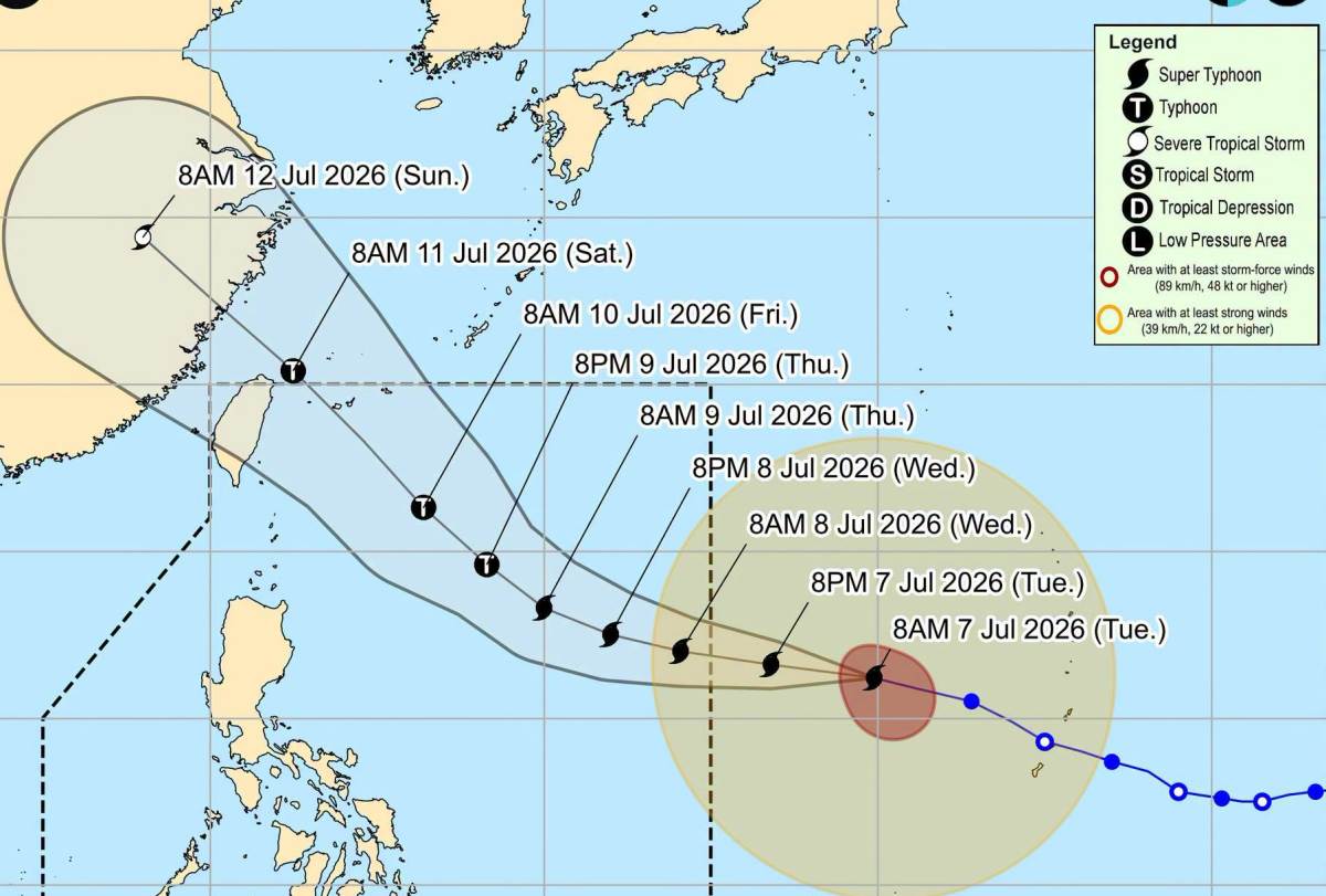
By about July 10, the storm will begin to weaken. Forecast on July 11, the storm's center will pass through the northern area of Taiwan (China), before making landfall in Fujian province (China) around July 12 and then continue to go deep inland and degrade.
Although the possibility of super typhoon Ba Vi entering the East Sea is assessed as very low due to the typhoon's circulation having a very wide radius, the typhoon can still affect weather conditions in this sea area.
From July 9, Southwest winds in the South of the East Sea, including the Truong Sa archipelago sea area, are forecast to gradually strengthen to level 6. On July 10-11, the North, Central and South of the East Sea, including the Hoang Sa and Truong Sa archipelago sea areas, may experience strong winds of level 6-7, waves 3-5 m high, and strong rough seas.
The meteorological agency recommends that ships operating at sea regularly update on the developments of Super Typhoon Ba Vi to proactively have prevention plans, ensuring safety for people and vehicles.
People and tourists planning to go to sea and mainland areas affected by the super typhoon should pay attention to considering their itinerary. Check the flight schedule and follow local instructions to avoid dangerous storms.


