The Philippine Atmospheric, Geophysical and Astronomical Services Administration (PAGASA) forecasts that two tropical depressions are about to form near the East Sea, one of which is likely to strengthen into a storm and enter the East Sea.
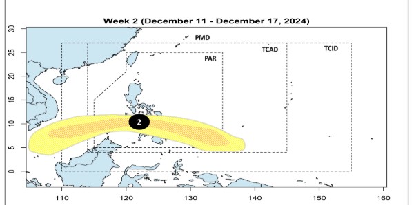
Accordingly, during the week from December 4 to December 10, a new low pressure area will appear in the southern area of PAGASA's TCAD forecast area. This low pressure area will gradually move into the Philippine forecast area (PAR) but is forecast to have little chance of strengthening into a storm.

Next, during the week of December 11 to 17, a new tropical depression will form near the South China Sea, south of PAGASA’s TCAD forecast area. The second depression is forecast to enter PAR and Visayas - Northern Mindanao with the potential to intensify into a low to moderate storm.
According to forecasts, this tropical depression is likely to enter the East Sea and approach the southern waters of Vietnam. This depression is likely to strengthen into a storm from December 11 to 17.

Previously, PAGASA forecasted that 1 to 2 tropical storms may enter PAR in December. Although the typhoon season is over, residents and tourists must always be vigilant and ready in case a tropical storm or typhoon affects the Philippines.
With the current weather conditions, people and tourists who want to travel to the Philippines at this time should pay attention to weather forecasts and check flight schedules regularly to avoid missing information, in case the trip is affected by storms.


