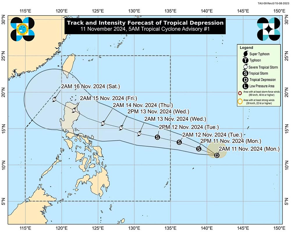
The low pressure area outside the Philippine Area of Responsibility (PAR) has intensified into a tropical depression, according to the Philippine Atmospheric, Geophysical and Astronomical Services Administration (PAGASA).
According to the state weather agency's 5 a.m. bulletin on November 11, the tropical depression was last detected 1,620 kilometers east of Eastern Visayas, with maximum sustained winds of 45 kilometers per hour near its center.

Currently, the tropical depression is moving in the West Northwest direction at a speed of 35 km/h and has gusts of up to 55 km/h.
The tropical depression will move steadily in the above direction and may enter PAR tomorrow morning (November 12).
Once it enters PAR, the storm will be named Ofel, marking the 15th tropical storm to enter the Philippines this year.
“The tropical depression may make landfall in Northern or Central Luzon on Thursday evening (November 14) or early Friday morning (November 15),” PAGASA meteorologist added.
The tropical depression is expected to strengthen into a severe tropical storm within the next 48 hours and could reach peak intensity before making landfall.
Meanwhile, typhoon Toraji (local name: Nika) made landfall in the Philippines this afternoon (November 11), causing heavy rain and strong winds across Northern Luzon.

Tourists planning to explore the Philippines during this time should pay attention to weather forecasts. This is the rainy season in this island nation (from June to October).
The ideal time to visit the Philippines is from November to April, when temperatures are pleasant and there is little rain. However, there is still a risk of typhoons forming late in November and December.
If you plan to travel to the Philippines and areas predicted to be affected by the storm, visitors should proactively monitor announcements from airlines, transport units, and travel companies to proactively plan, build a suitable schedule and ensure safety.


